
Tripura is a state in northeastern India. The third-smallest state in the country, it covers 10,491 km2 (4,051 sq mi); and the seventh-least populous state with a population of 3.67 million. It is bordered by Assam and Mizoram to the east and by Bangladesh to the north, south and west. Tripura is divided into 8 districts and 23 sub-divisions, where Agartala is the capital and the largest city in the state. Tripura has 19 different tribal communities with a majority Bengali population. Bengali, English and Kokborok are the state's official languages.
Agartala is the capital and the largest city of the Indian state of Tripura, situated on the banks of Haora/Saidra River, about 2 kilometres (1.2 mi) east of the border with Bangladesh and about 2,499 km (1,552 mi) from the national capital, New Delhi. According to 2022 AMC data, Agartala is the second most populous city after Guwahati in Northeast India. It is India's third international internet gateway and being developed under the Smart Cities Mission.

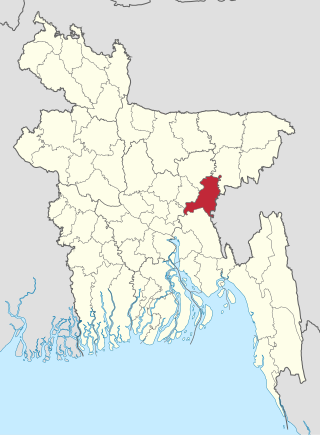
Brahmanbaria is a district in eastern Bangladesh located in the Chittagong Division. Geographically, it is mostly farmland and is topographically part of the Gangetic Plain. It is bounded by the districts of Kishoreganj and Habiganj to the north, Narsingdi District and Narayanganj to the west, Comilla to the south, and the Indian state of Tripura to the east. It was a part of Comilla District until 15 February 1984.

Maharaja Bir Bikram Airport, also known as Agartala Airport, is an international airport situated 12 kilometres northwest of Agartala, the capital of Tripura. It is administered by the Airports Authority of India (AAI). It is the second busiest airport in North-East India after Lokpriya Gopinath Bordoloi Airport in Guwahati and 29th busiest airport in India. It is the third international airport in North-East India, after Lokpriya Gopinath Bordoloi Airport and Imphal Airport.

Akhaura is an upazila of Brahmanbaria District, a district under Chattogram, Bangladesh. Akhaura Upazila has an area of 99.28 km2. The main river that run through this upazila is the Titas River. Akhaura played an important historical role during both World War II and Liberation War of Bangladesh.
Transport between India and Bangladesh bears much historical and political significance for both countries, which possessed no ground transport links for 43 years, starting with the partition of Bengal and India in 1947. The Kolkata–Dhaka Bus (1999) and the Dhaka–Agartala Bus (2001) are the primary road links between the two countries; a direct Kolkata-Agartala running through Dhaka, the capital of Bangladesh is being developed by both countries. The Maitree Express was launched to revive a railway link between Kolkata and Dhaka that had been shut for 43 years.

The Bangladesh–India border, known locally as the Radcliffe line (IB), is an international border running between the republics of Bangladesh and India that demarcates the six divisions of Bangladesh and the Indian states.
Indian Institutes of Information Technology (IIITs) are centrally funded technical institutes located across India. They are a group of 26 interdisciplinary technology-based-engineering research institutions in India which are focused on information technology. They are governed by the Indian Institutes of Information Technology Bill, 2014 which refers to them as Institutes of National Importance and lays down their powers, duties, and framework for governance as the country's premier institutions in the field of information technology. was introduced in the Lok Sabha. Five (5) Institutes of them are established, Fully funded and managed by the Ministry of Education (MOE), Gov. of India. The other 21 Institutions are set up on the public-private partnership (PPP) model, funded by the central government, state governments and industry partners in the ratio 50:35:15.

The Akhaura–Laksam–Chittagong line is a railway line connecting Akhaura and Chittagong, via Laksam in Bangladesh. There are branch lines from Laksam to Chandpur and Noakhali. This line is under the jurisdiction of Bangladesh Railway.

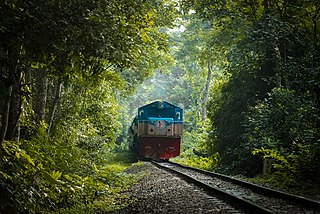
The Lumding–Sabroom section is a railway line under Lumding railway division of Northeast Frontier Railway zone of Indian Railways. It is a single 1,676 mm broad-gauge track from Lumding in Nagaon District of Assam state to Agartala in West Tripura district of Tripura state. The 43 km-long 1,676 mm segment from Agartala southwards to Udaipur, Tripura was completed in 2016 and became operational on 23 January 2017. The remaining 70 km long track to Sabroom at the bank of Feni River at Bangladesh border was completed in 2019 and became operational on 3 October 2019.

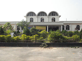
Agartala Railway Station is located 5.5 km (3.4 mi) from Agartala in Tripura, India. It is the second capital city in northeast India to be connected to the country's railway map, moreover Agartala is the first state capital of independent India to be connected with a rail network. Before 2015 the 413-kilometre (257 mi) route was connected to Lumding with a metre-gauge track, but after the gauge conversion to broad gauge in 2016, the track is connected directly to Guwahati and the rest of India.

Lumding Junction Railway Station serves the Indian city of Lumding in Assam. It is the divisional headquarter of Lumding railway division of NFR. It is located in Hojai district. It is the 2nd biggest railway station of Lumding railway division, after Guwahati. It is one of the oldest railway station in India built under Assam Bengal Railway. It consists of 5 platforms with a total of 68 halting trains & 3 originating trains. The station consists of double diesel line.

Brahmanbaria is a city of Bangladesh and the capital of Brahmanbaria Sadar Upazila as well as Brahmanbaria District. It is the second largest city after Cumilla in eastern Bangladesh and one of the oldest municipalities in Bangladesh, established in 1868. Brahmanbaria was declared a district headquarters in 1984. Its municipality area has a population of 265,000 in 2022. It is the 17th largest city in Bangladesh.
The Port of Ashuganj is a notable river port in eastern Bangladesh. It is one of the important industrial ports of the Bengal delta. It is located on the Meghna River. The port is a regional transshipment center in Eastern South Asia.
Karimganj Junction Railway Station serves the Indian city of Karimganj in Assam. It belongs to Lumding railway division of Northeast Frontier Railway zone. It is located in Karimganj district. It is the fourth most busiest railway station in Barak Valley. It is also one of the three railway stations serving the city of Karimganj, the others being Longai and New Karimganj. It is one of the oldest railway station in India built in the year 1898 under Assam Bengal Railway. It consists of two platforms with a total of 15 halting trains. It serves as the main halt for all passenger trains from Silchar, Agartala, Dharmanagar, Dullabcherra, Badarpur, and Mahisasan. The station consists of a single Electric-Line.

The Land Ports Authority of India or LPAI is a statutory body working under the Ministry of Home Affairs, Government of India is responsible for creating, upgrading, maintaining and managing border infrastructure in India. It manages several Integrated Check Posts (ICPs) all across Borders of India.
Maitri Setu is a 1.9-kilometre (1.2 mi) bridge on Feni River which links Sabroom in Tripura, India and Ramgarh in Chittagong, Bangladesh leading to Chittagong port, thus providing a shorter and more economical alternate land route between India's eastern and western states compared to the longer route through Assam. On 9 March 2021, it was officially opened to public by the Prime Minister of India, Narendra Modi and Bangladesh Prime Minister Sheikh Hasina.
Akhaura Junction railway station is a railway junction located in Akhaura Upazila, Brahmanbaria District, Chittagong division, Bangladesh.
Akhaura–Agartala line is a railway line between Bangladesh and India. The railway line is a pivotal achievement for both countries. It has several benefits including, boosting tourism in the North East of India, reducing travel time from Kolkata-Agartala from 38 hours to a mere 10 hours by rail, reducing cost of cargo transport to and from Bangladesh and the North East of India, improving bilateral relations and more. It is expected to also act as a gateway to other NE Indian states such as Assam, southern Mizoram and Arunachal Pradesh.
