Brahmanbaria

Last updated

Brahmanbaria
ব্রাহ্মণবাড়িয়া (Brahmanbaria)
Jamia Islamia Yunusia, Paikpara.jpg
Brahmanbaria city
Nickname: 
Baunbaira
Bangladesh adm location map.svg
Red pog.svg
Brahmanbaria
Location in Brahmanbaria
Coordinates: 23°57′56″N91°06′29″E / 23.965593°N 91.107997°E / 23.965593; 91.107997
CountryBangladesh
Division Chittagong Division
District Brahmanbaria District
EstablishmentLate 1700 CE
Municipality1769
Administrative District1984
Government
  Type Pourashava
   City Mayor Nayar Kabir
Area
  Total27 km2 (10.4 sq mi)
Elevation
[3]
15 m (49.2 ft)
Population
 (2011) [2]
  Total521,994
  Density19,000/km2 (50,000/sq mi)
Demonym Brahmanbarian
Time zone UTC+6 (BST)
Postal code
3400 [4]
National Calling Code +880
Local Calling Code +88-0851

Brahmanbaria [5] (Bengali : ব্রাহ্মণবাড়িয়া, romanized: Brāhmaṇabāṛiẏā) [6] is a city of Bangladesh and the capital of Brahmanbaria Sadar Upazila as well as Brahmanbaria District. It is the second largest city after Cumilla in eastern Bangladesh [7] and one of the oldest municipalities in Bangladesh, established in 1868. [8] Brahmanbaria was declared a district headquarters in 1984. Its municipality area has a population of 270,000 in 2020. It is the 17th largest city in Bangladesh.

Contents

History

Pakistani Eastern Command plan for the defence of East Pakistan from 1967 to 1971 (generic representation--some unit locations not shown) baaNlaadesher saamrik (1967-1971) priklpnaa.png
Pakistani Eastern Command plan for the defence of East Pakistan from 1967 to 1971 (generic representation—some unit locations not shown)

During the Indo-Pakistan War of 1971 for the liberation of Bangladesh, when Pakistan Army planners predicted India would launch its main attack in the east along the Akhaura–Brahmanbaria axis, it had no brigades available to cover this area, and Pakistan Army moved its 27th brigade from Mymensingh to Akhaura after retaining two battalions of 27th brigade at Mymensingh to form the 93rd Brigade to defend Mymensingh. [9] Pakistan Army's 93,000 troops unconditionally surrendered to the Indian Army and India's local ally Mukti Bahini on 16 December 1971. This day and event is commemorated as the Bijoy Dibos (Bengali : বিজয় দিবস) in Bangladesh and Vijay Diwas in India. [10]

Administration

Brahmanbaria was given city status in 1984.[ citation needed ] Brahmanbaria Municipality is subdivided into 20 wards. [11]

Geography and climate

The Titas River, seen from Brahmanbaria Titas river sun set view 01.JPG
The Titas River, seen from Brahmanbaria

Brahmanbaria is located in the East-Central region of Bangladesh. Its nearby cities are Dhaka, Cumilla, Narayanganj and Agartala. This city is in the bank of Titas River. Also there is Meghna River in the west of Brahmanbaria. [12] [ better source needed ]

Brahmanbaria has a tropical wet and dry climate.

MonthJanFebMarAprMayJunJulAugSepOctNovDecYear
Mean daily maximum °C (°F)25
(77)
28
(82)
32
(90)
33
(91)
33
(91)
32
(90)
32
(90)
32
(90)
32
(90)
31
(88)
29
(84)
27
(81)
31
(87)
Daily mean °C (°F)18
(64)
22
(72)
26
(79)
28
(82)
28
(82)
29
(84)
29
(84)
29
(84)
28
(82)
27
(81)
22
(72)
22
(72)
25
(77)
Mean daily minimum °C (°F)10
(50)
14
(57)
19
(66)
22
(72)
23
(73)
25
(77)
25
(77)
25
(77)
24
(75)
23
(73)
17
(63)
17
(63)
20
(69)
Average precipitation mm (inches)14.4
(0.57)
39.8
(1.57)
72.8
(2.87)
168.2
(6.62)
315.4
(12.42)
344.9
(13.58)
367.9
(14.48)
247.5
(9.74)
197.6
(7.78)
148.5
(5.85)
30.4
(1.20)
8.9
(0.35)
1,956.3
(77.03)
Average precipitation days (≥ 0.1 mm)4571219232826221331163
Source: Worldweatheronline [13]

Notable residents

Syed Abdul Hadi is from Brahmanbaria ,is a Bangladeshi musician. He won the National Film Award five times . In 2000, he was awarded the Ekushey Padak , the second highest civilian honor of Bangladesh, for his contribution to music . Brahmanbaria also produced actresses like Zakia Bari Momo, who won LUX Channel I Superstar, Tasnova Hoque Elvin. Alamgir is evergreen actor of Cinema of Bangladesh. He start working in mid '80s and he is still an actor. [14] Brahmanbaria has other people like Al Mahmud, Cricketer Mohammad Ashraful, Abdul Kadir and Syed Shamsul Haque who are poets. Nawaab Syed Shamsul Huda was a leader of the Muslim League. Ali Azam (politician) was a leader of Awami League. Shakil Ahmed was the director general of border guards, who had heavily secured the borders of Bangladesh.

T A Road near Kandipara in Brahmanbaria town T A Road near Kandipara, N 103, Brahmanbaria.jpg
T A Road near Kandipara in Brahmanbaria town
T A Road, Brahmanbaria T.A Road Brahmanbaria.jpg
T A Road, Brahmanbaria

See also

Destinations

Related Research Articles

<span class="mw-page-title-main">Comilla District</span> District of Bangladesh in Chittagong Division

Comilla District, officially known as Cumilla District, is a district located in southeastern Bangladesh. It lies about 100 kilometres south east of Dhaka. Comilla is bordered by Brahmanbaria and Narayanganj districts to the north, Noakhali and Feni districts to the south, Tripura state of India to the east and Munshiganj and Chandpur districts to the west.

<span class="mw-page-title-main">Jamalpur District</span> District of Bangladesh in Mymensingh

Jamalpur is a district in Bangladesh, part of the Mymensingh Division. It was established in 1978.

<span class="mw-page-title-main">Tangail District</span> District in Dhaka Division, Bangladesh

Tangail is a district (zila) in the central region of Bangladesh. In 1969, Tangail district was created by Tangail Mohokuma from its 237 square kilometers of land and 3177 square kilometers of land acquired from Mymensingh district. It is the largest district of Dhaka division by area and second largest by population. The population of Tangail zila is about 4 million and its area is 3,414.28 square kilometres (1,318.26 sq mi). The main city of the district is Tangail. It is surrounded by Jamalpur District on the north, the Dhaka and Manikganj Districts on the south, Mymensingh and Gazipur on the east, and Sirajganj on the west.

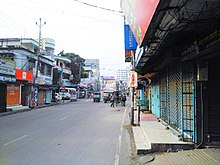
Tangail is a city of Tangail District in central Bangladesh. A significant city in Bangladesh, Tangail lies on the bank of the Louhajang River, 83 kilometres (52 mi) northwest of Dhaka, the nation's capital. It is the 25th most populous city in Bangladesh.

<span class="mw-page-title-main">Brahmanbaria District</span> District of Bangladesh in Chattogram Division

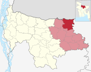
Brahmanbaria is a district in eastern Bangladesh located in the Chittagong Division. Geographically, it is mostly farmland and is topographically part of the Gangetic Plain. It is bounded by the districts of Kishoreganj and Habiganj to the north, Narsingdi District and Narayanganj to the west, Comilla to the south, and the Indian state of Tripura to the east. It was a part of Comilla District until 15 February 1984.

<span class="mw-page-title-main">Habiganj District</span> District of Bangladesh in Sylhet Division

Habiganj, formerly known as Habibganj, is a district in north-eastern Bangladesh, located in the Sylhet Division. It was established as a district in 1984 as a successor to its subdivision status since 1867. It is named after its headquarters, the town of Habiganj.

<span class="mw-page-title-main">Akhaura Upazila</span> Upazila in Chittagong, Bangladesh

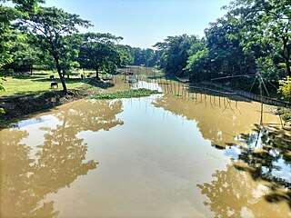
Akhaura is an upazila of Brahmanbaria District, a district under Chattogram, Bangladesh. Akhaura Upazila has an area of 99.28 km2. The main river that run through this upazila is the Titas River. Akhaura played an important historical role during both World War II and Liberation War of Bangladesh.

<span class="mw-page-title-main">Brahmanbaria Sadar Upazila</span> Upazila in Chittagong, Bangladesh

Brahmanbaria Sadar is an upazila of Brahmanbaria District in the Division of Chittagong, Bangladesh. Brahmanbaria Sadar is located at 23.9528°N 91.1167°E.

<span class="mw-page-title-main">Kasba Upazila</span> Upazila in Chittagong, Bangladesh

Kasba is an upazila of Brahmanbaria District, Chittagong Division in east-central Bangladesh. Kasba is located approximately 150 km north of Chittagong. It was part of greater Comilla District until 1984.

<span class="mw-page-title-main">Laksam Upazila</span> Upazila in Chittagong, Bangladesh

Laksam is an upazila of Comilla District in the Division of Chittagong, Bangladesh. Laksam is widely known as the birthplace of Nawab Faizunnesa Chowdhurani.

<span class="mw-page-title-main">Moulvibazar Sadar Upazila</span> Upazila in Sylhet, Bangladesh

Moulvibazar Sadar is an upazila of Moulvibazar District in the Division of Sylhet, Bangladesh.

<span class="mw-page-title-main">Kishoreganj Sadar Upazila</span> Upazila in Dhaka Division, Bangladesh

Kishoreganj Sadar is an upazila of Kishoreganj District in the Division of Dhaka, Bangladesh. It is best known as the home upazila of Syed Nazrul Islam, an Acting President of Bangladesh.

<span class="mw-page-title-main">Netrokona Sadar Upazila</span> Upazila in Mymensingh, Bangladesh

Netrokona Sadar is an upazila (sub-district) of Netrokona District under Mymensingh Division, Bangladesh.

<span class="mw-page-title-main">Comilla</span> City in eastern Bangladesh

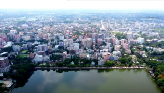
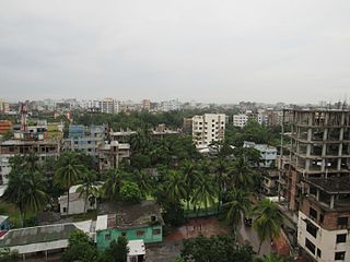
Comilla, officially spelled Cumilla, is a metropolis on the banks of the Gomti River in eastern Bangladesh. Comilla was one of the cities of ancient Bengal. It was once the capital of Tripura kingdom. Comilla Airport is located in the Dulipara area of Comilla city. Along with the Comilla Economic Zone EPZ, various industrial factories have come up at the airport, making the airport area a business and commercial city. Comilla City is a division centered city district with surrounding districts coming to Comilla in more diverse areas of work. Besides, Bibi Bazar land port has come up 5 km away from Comilla city. The area of Comilla City Corporation is 53.04 square kilometers, so the surrounding areas of the main city fall under the jurisdiction of the City Corporation. The urban areas falling outside the city corporation are considered as suburbs with a population of 6 hundred thousand.

<span class="mw-page-title-main">Military plans of the Bangladesh Liberation War</span> Military plans of the Bangladesh Liberation War

Prior to Bangladesh Liberation War in 1971, India had no plans for large scale military action in East Pakistan. Since the Sino-Indian War of 1962, the primary objective of the Indian Army Eastern Command was the defence of the Indian northern and eastern borders, defending the "Shiliguri Corridor", and on combating insurgencies raging in Mizoram, Nagaland, Manipur and the Naxalites in West Bengal.

<span class="mw-page-title-main">Gokarna, Bangladesh</span> Village in Chittagong Division, Bangladesh

Gokarna stands on the bank of Haral River in Bangladesh which connected with Titas River. This village was historically considered as a remote area; prior to the modern era of road travel its inhabitants relied on boats. Many highly respected people were born in Gokarna, including Nawaab Syed Shamsul Huda KCIE born in 1862 at this village. He became the first Muslim president of the Imperial Legislative Council in 1921. In the past, people traveled from Gokarna to Dhaka and Calcutta by river.

<span class="mw-page-title-main">Kishoreganj-1</span> Constituency of Bangladeshs Jatiya Sangsad

Kishoreganj-1 is a constituency represented in the Jatiya Sangsad of Bangladesh from 2008 to 2018 by Sayed Ashraful Islam of the Awami League. His death in January 2019, days after his re-election, will trigger a by-election.

<span class="mw-page-title-main">Brahmanbaria-1</span> Constituency of Bangladeshs Jatiya Sangsad

Brahmanbaria-1 is a constituency represented in the Jatiya Sangsad of Bangladesh since January 2024 by Syed A.K. Ekramuzzaman of the independent politician.

References

  1. "Area, Population and Literacy Rate by Paurashava −2001" (PDF). Bangladesh Bureau of Statistics. Archived from the original (PDF) on 27 March 2005. Retrieved 18 September 2009.
  2. 1 2 ব্রাহ্মণবাড়িয়া সদর উপজেলা. Brahmanbaria Sadar Upazila (in Bengali). Archived from the original on 22 September 2019.
  3. "Bangladesh Elevation and Elevation Maps of Cities, Topographic Map Contour".
  4. www.geopostcodes.com. "ZIP Code database of Bangladesh". Geopostcodes.com. Retrieved 11 June 2008.
  5. "Wikivoyage". Map Data OpenStreetMap . Retrieved 11 July 2011.
  6. "Government Official Name". Local government in Bangladesh. Archived from the original on 12 June 2018. Retrieved 17 December 2014.
  7. "NGA GeoNames Database". National Geospatial-Intelligence Agency . Retrieved 14 July 2008.
  8. "About B.BARIA". Local government in Bangladesh . Retrieved 30 April 2022.
  9. Salik, Siddiq, Witness to Surrender, pp126
  10. "About us". Liberation War Museum. Archived from the original on 8 November 2011. Retrieved 21 November 2011.
  11. "National Web Portal of Bangladesh". Bangladesh National Web Portal. Archived from the original on 12 November 2014. Retrieved 17 December 2014.
  12. Bangladesh Compendium of Environment Statistics. Bangladesh Bureau of Statistics, Statistics Division, Ministry of Planning, Government of the People's Republic of Bangladesh. 2009.
  13. "Brahmanbaria, Bangladesh Travel Weather Averages (Worldweather)". Worldweatheronline. Retrieved 3 October 2015.
  14. "Alamgir | Film Star | Online Dhaka Guide ( অনলাইন ঢাকা গাইড) - an Information Guide for Dhaka City". Archived from the original on 4 March 2016. Retrieved 28 November 2015.