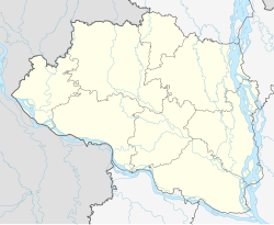
Sirajganj

Last updated

Sirajganj
সিরাজগঞ্জ
City
Jamuna Bridge.jpg
Bangabandhu Jamuna Eco Park.jpg
ymunaar shaant prkRti.jpg
STARTING OF A NEW LIFE.jpg
maajhider glp.jpg
Clockwise from top-left: Jamuna Bridge, Jamuna Eco Park, Hard Point, Bank of Jamuna River, China Barrage
Bangladesh Rajshahi location map.svg
Red pog.svg
Sirajganj
Bangladesh adm location map.svg
Red pog.svg
Sirajganj
Coordinates: 24°27′36″N89°42′18″E / 24.460°N 89.705°E / 24.460; 89.705
CountryFlag of Bangladesh.svg  Bangladesh
Division Rajshahi
District Sirajganj
Upazila Sirajganj Sadar
EstablishmentEarly 1800s
Municipality1869
Government
  Type Municipality
  MayorSayed Abdur Rouf Mukta [1]
Area
  Total28.49 km2 (11.00 sq mi)
Elevation
16 m (52 ft)
Population
  Total450,000
  Density16,000/km2 (41,000/sq mi)
Time zone UTC+6 (BST)

Sirajganj [lower-alpha 1] is a city in north-western Bangladesh on the right bank of the Jamuna River, located in Rajshahi Division. It is the administrative headquarters of Sirajganj District, and with a population of 450,000 is the 12th largest city in Bangladesh.

Contents

It is about 110 kilometres (68 mi) north west of the capital, Dhaka. It is the city where Pakistani Brig. Jehanzeb Arbab looted the bank back in 1971 during the Bangladesh Liberation War. It was once a principal centre of the jute trade.

History

During British rule, Sirajganj was a town in the Pabna District of Eastern Bengal and Assam. Its location on the right bank of the Jamuna River or main stream of the Brahmaputra was a six-hour journey by steamer from the railway terminal at Goalundo. It was the chief river mart for jute in northern Bengal, with several jute presses. The jute mills were closed after the 1897 Assam earthquake. The population according to the 1901 census of India was 23,114. [2]

Demographics

Historical population
YearPop.±% p.a.
1974 90,517    
1981 97,141+1.01%
1991 112,690+1.50%
2001 131,634+1.57%
2011 167,200+2.42%
2022 450,000+9.42%
Sources: [3]

According to the 2022 Bangladesh census, Sirajganj city had a population of 450,000. [4] :388–394

According to the 2011 Bangladesh census, Sirajganj city had 35,556 households and a population of 167,200. 31,096 (19.57%) were under 10 years of age. The literacy rate (age 7 and over) was 63.22%, compared to the national average of 51.8%, and the sex ratio was 980 females per 1000 males. [5] [6]

Religion

Religions in Sirajganj city (2011) [3]
ReligionPercent
Islam
92.13%
Hinduism
7.82%
Other or not stated
0.05%

Muslims make up 92.13% of the population, while Hindus are 7.82% of the population. The Hindu population has remained relatively constant while the Muslim population has constantly increased. The remaining 0.05% people follow other religions, mainly Christianity and Sarnaism. There are 300 mosques, 15 temples and 1 Christian cemetery in the city. [3]

Points of interest

Transport

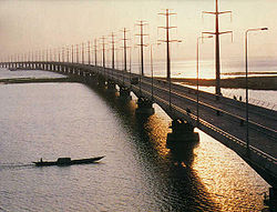
In the later half of the 19th century, Sirajganj was an important river port. It was the main collection point for jute produced in northern Bengal and western Mymensingh. After the 1897 Assam earthquake, which damaged infrastructure and shifted the course of the river farther from the city, its significance declined. It was eclipsed by Narayanganj, another river port, which also had a rail connection. [7]

Not until 1915 was Sirajganj connected to the railway network, with the opening of the Sara-Sirajganj line. [7] As of 2022, there is an Intercity train to Dhaka six days a week. [8]

East-West national highway N405 passes just south of the city. It runs east, across the Jamuna Bridge, about 24 kilometres (15 mi) to the Joydebpur–Jamalpur Highway at Elenga, and west about 16 kilometres (9.9 mi) to the Dhaka–Banglabandha Highway. [9]

Education

There are two medical schools in the city, the public Shaheed M. Monsur Ali Medical College, established in 2014, and the private North Bengal Medical College & Hospital, established in 2000. As of May 2019, they are respectively allowed to admit 51 and 85 students annually. [10]

There are eight colleges in the city. They include Sirajganj Government College, founded in 1940, Islamia Government College (1887), and Government Rashidazzoha Womens College. [11] [12]

According to Banglapedia, B.L. Government High School, founded in 1869, Jnandayini High School (1884), Saleha Ishaque Government Girls' High School, and Victoria High School (1898) are notable secondary schools. [12]

Notable people

Related Research Articles

<span class="mw-page-title-main">Dhaka Division</span> Administrative division of Bangladesh

Dhaka Division is an administrative division within Bangladesh. Dhaka serves as the capital city of the Dhaka Division, the Dhaka District and Bangladesh. The division remains a population magnet, covers an area of 20,508.8 km2 with a population in excess of 44 million, It is the most populous country second level division of the world, growing at 1.94% rate since prior count, compared with national average of 1.22%. However, national figures may include data skewing expatriation of male labor force as gender ratio is skewed towards females.

<span class="mw-page-title-main">Rajshahi Division</span> Division of Bangladesh

Rajshahi Division is one of the eight first-level administrative divisions of Bangladesh. It has an area of 18,174.4 square kilometres (7,017.2 sq mi) and a population at the 2022 Census of 20,353,119. Rajshahi Division consists of 8 districts, 70 Upazilas and 1,092 Unions.

<span class="mw-page-title-main">Jamalpur District</span> District of Bangladesh in Mymensingh

Jamalpur is a district in Bangladesh, part of the Mymensingh Division. It was established in 1978.

<span class="mw-page-title-main">Pabna District</span> District of Bangladesh in Rajshahi Division

Pabna District is a district in central Bangladesh. It is an economically important district. Its administrative capital is the eponymous Pabna town.

<span class="mw-page-title-main">Tangail District</span> District in Dhaka Division, Bangladesh

Tangail is a district (zila) in the central region of Bangladesh. In 1969, Tangail district was created by Tangail Mohokuma from its 237 square kilometers of land and 3177 square kilometers of land acquired from Mymensingh district. It is the largest district of Dhaka division by area and second largest by population. The population of Tangail zila is about 4 million and its area is 3,414.28 square kilometres (1,318.26 sq mi). The main city of the district is Tangail. It is surrounded by Jamalpur District on the north, the Dhaka and Manikganj Districts on the south, Mymensingh and Gazipur on the east, and Sirajganj on the west.

<span class="mw-page-title-main">Jamuna River (Bangladesh)</span> River in Bangladesh

The Jamuna River is one of the three main rivers of Bangladesh. It is the lower stream of the Brahmaputra River, which originates in Tibet as Yarlung Tsangpo, before flowing through India and then southwest into Bangladesh. The Jamuna flows south and joins the Padma River (Pôdda), near Goalundo Ghat, before meeting the Meghna River near Chandpur. It then flows into the Bay of Bengal as the Meghna River.

Tangail is a city of Tangail District in central Bangladesh. A significant city in Bangladesh, Tangail lies on the bank of the Louhajang River, 83 kilometres (52 mi) northwest of Dhaka, the nation's capital. It is the 25th most populous city in Bangladesh.

<span class="mw-page-title-main">Naogaon District</span> District of Bangladesh in Rajshahi Division

Naogaon District is a district in northern Bangladesh, part of the Rajshahi Division. It is named after its headquarters, the city of Naogaon in Naogaon Sadar Upazila.

<span class="mw-page-title-main">Sirajganj District</span> District of Bangladesh in Rajshahi Division

Sirajganj District is a district in the North Bengal region of Bangladesh, located in the Rajshahi Division. It is the 25th largest district by area and 9th largest district by population in Bangladesh. It is known as the gateway to North Bengal.

<span class="mw-page-title-main">Pabna</span> Largest City as well as District headquarter of Pabna district

Pabna is a city of Pabna District, Bangladesh and the administrative capital of the eponymous Pabna District. It is on the north bank of the Padma River and has a population of about 300,109.

<span class="mw-page-title-main">North Bengal</span> Northern part of Bengal covering India and Bangladesh

North Bengal or Uttar Banga is a term used for the north-western part of Bangladesh and northern part of West Bengal. The Bangladesh part denotes the Rajshahi Division and Rangpur Division. Generally, it is the area lying west of Jamuna River and north of Padma River and includes the Barind Tract. The West Bengal part denotes Jalpaiguri Division and the Malda division together. The Bihar parts include the Kishanganj district. It also includes parts of Darjeeling Hills. Traditionally, the Ganga River divides Bengal into South Bengal and North Bengal, divided again into Terai and Dooars regions. Jalpesh and jatileswar are some of the most popular sacred places.

<span class="mw-page-title-main">Ismail Hossain Siraji</span> Bengali writer

Syed Ismail Hossain Siraji was a Bengali author and poet from Sirajganj in present-day Bangladesh. He is considered to be one of the key authors of period of the Bengali Muslim reawakening; encouraging education and glorifying the Islamic heritage. He also contributed greatly to introducing the Khilafat Movement in Bengal, and provided medical supplies to the Ottoman Empire during the Balkan Wars. Anal-Prabaha, his first poetry book, was banned by the government and he was subsequently imprisoned as the first South Asian poet to allegedly call for independence against the British Raj. The government issued Section 144 against him 82 times in his lifetime.

<span class="mw-page-title-main">Tarash Upazila</span> Upazila in Rajshahi, Bangladesh

Tarash is an upazila, or sub-district of Sirajganj District, located in Rajshahi Division, Bangladesh.

<span class="mw-page-title-main">Ullahpara Upazila</span> Upazila in Rajshahi, Bangladesh

Ullapara is an upazila, or sub-district of Sirajganj District, located in Rajshahi Division, Bangladesh.

<span class="mw-page-title-main">Shahjadpur Upazila</span> Upazila in Rajshahi, Bangladesh

Shahjadpur is an upazila, or sub-district of Sirajganj District, located in Rajshahi Division, Bangladesh.

<span class="mw-page-title-main">Bhangura Upazila</span> Upazila in Rajshahi, Bangladesh

Bhangura or Bhangoora is an upazila of Pabna District in Rajshahi Division, Bangladesh.

<span class="mw-page-title-main">Abdul Hamid Khan Bhashani</span> Bangladeshi political leader (1880–1976)

Abdul Hamid Khan Bhashani, often shortened as Maulana Bhashani, was a Bengali politician. His political tenure spanned the British colonial India, Pakistan and Bangladesh periods. Maulana Bhashani was popularly known by the honorary title Mozlum Jananeta for his lifelong stance advocating for the poor. He gained nationwide mass popularity among the peasants and helped to build the East Pakistan Peasant Association. Owing to his political leaning to the left, often dubbed Islamic Socialism. he was also called 'The Red Maulana'. He is considered as one of the main pillars of Bangladeshi independence of 1971.

Talukdar is a historic occupational title in South Asia which is now used as a surname. Notable people with the surname include:

<span class="mw-page-title-main">Mohammad Najibar Rahman</span>

Mohammad Najibar Rahman was a Bengali writer of fiction from the nineteenth century. He gained great popularity as a novelist during his times and was honored with the title "Sahityaratna". He is considered as a representative of Bengali Muslim writers of the era and is most known for his novel Anwara (1914).

Elliott Bridge is an old bridge over the Boral River in Sirajganj, north-western Bangladesh. The pillarless bridge is named after the Lieutenant Governor named Charles Alfred Elliott. It cost 45 thousand takas to make it. It is one of the major attractions of Sirajganj city.

References

  1. সিরাজগঞ্জের তিনটিতে আ.লীগ একটিতে বিদ্রোহী প্রার্থী জয়ী [In Sirajganj, the AL won three, in one the rebel candidate won]. jagonews24.com (in Bengali). 18 January 2021.
  2. Chisholm, Hugh, ed. (1911). "Sirajganj"  . Encyclopædia Britannica (11th ed.). Cambridge University Press.
  3. 1 2 3 "Bangladesh Population and Housing Census 2011 Zila Report – Sirajganj" (PDF). bbs.gov.bd. Bangladesh Bureau of Statistics.
  4. Population and Housing Census 2022 National Report (PDF). Vol. 1. Bangladesh Bureau of Statistics. November 2023.
  5. "Population and Housing Census 2011 - Volume 3: Urban Area Report" (PDF). Bangladesh Bureau of Statistics. August 2014. p. 262.
  6. "Population and Housing Census 2011: Bangladesh at a Glance" (PDF). Bangladesh Bureau of Statistics . Archived from the original (PDF) on 28 July 2014. Retrieved 21 July 2014.
  7. 1 2 Ali, Tariq Omar (2018). A Local History of Global Capital: Jute and Peasant Life in the Bengal Delta. Princeton University Press. pp. 69–70, 72. ISBN   978-1-4008-8928-0.
  8. "Sirajganj Bazar Schedule". Bangladesh Railway .
  9. "RHD Road Network, Rajshahi Zone". Roads and Highways Department . 2019. Retrieved 29 March 2022.
  10. "Statistical Year Book Bangladesh 2018" (PDF). Bangladesh Bureau of Statistics . May 2019. pp. 485–486.
  11. "List of Colleges". Department of Secondary and Higher Education. Retrieved 6 September 2020.
  12. 1 2 Islam, Kamrul (2012). "Sirajganj Sadar Upazila". In Islam, Sirajul; Jamal, Ahmed A. (eds.). Banglapedia: National Encyclopedia of Bangladesh (Second ed.). Asiatic Society of Bangladesh.
  13. 1 2 ভাষা ও সংস্কৃতি [Language and culture]. Sirajganj District (in Bengali).
  14. Shazu, Shah Alam (1 December 2010). "'I always work in my own way'". The Daily Star .
  15. Shazu, Shah Alam (4 October 2017). "Birthday felicitations for Zahid Hasan!". The Daily Star .
  16. Hossain, Selina; Islam, Nurul; Hossain, Mobarak, eds. (2000). Bangla Academy Dictionary of Writers. Bangla Academy. p. 115. ISBN   984-07-4052-0.
  17. "Ex-AL lawmaker Mirza Latif passes away". The Daily Star . 7 November 2007.
  18. Bhattacharya, Sabyasachi (2014). The Defining Moments in Bengal: 1920–1947. Oxford University Press. ISBN   978-0-19-908934-5. Ismail Husain Siraji of Sirajganj town in Pabna district of East Bengal

Notes

  1. Bengali: সিরাজগঞ্জ, romanized: Sirājagañja