Related Research Articles

The Republic of Colombia is situated largely in the north-west of South America, with some territories falling within the boundaries of Central America. It is bordered to the north-west by Panama; to the east by Brazil and Venezuela; to the south by Ecuador and Peru; and it shares maritime limits with Costa Rica, Nicaragua, Honduras, Jamaica, the Dominican Republic, and Haiti.

Ancash is a department and region in western Peru. It is bordered by the departments of La Libertad on the north, Huánuco and Pasco on the east, Lima on the south, and the Pacific Ocean on the west. Its capital is the city of Huaraz, and its largest city and port is Chimbote. The name of the region originates from the Quechua word anqash, from anqas ('blue') or from anka ('eagle').
Barbeau Peak is a mountain in Qikiqtaaluk, Nunavut, Canada. Located on Ellesmere Island within Quttinirpaaq National Park, it is the highest mountain in Nunavut and the Canadian Arctic. The mountain was named in 1969 after Marius Barbeau, a Canadian anthropologist whose research into First Nations and Inuit cultures gained him international acclaim.

The Magdalena River is the main river of Colombia, flowing northward about 1,528 kilometres (949 mi) through the western half of the country. It takes its name from the biblical figure Mary Magdalene. It is navigable through much of its lower reaches, in spite of the shifting sand bars at the mouth of its delta, as far as Honda, at the downstream base of its rapids. It flows through the Magdalena River Valley.
A cordillera is a small chain and/or network system of mountain ranges, such as those in the west coast of the Americas. The term is borrowed from Spanish, where the word comes from cordilla, a diminutive of cuerda ('rope').

Illimani is the highest mountain in the Cordillera Real of western Bolivia. It lies near the cities of El Alto and La Paz at the eastern edge of the Altiplano. It is the second highest peak in Bolivia, after Nevado Sajama, and the eighteenth highest peak in South America. The snow line lies at about 4,570 metres (15,000 ft) above sea level, and glaciers are found on the northern face at 4,982 m (16,350 ft). The mountain has four main peaks; the highest is the south summit, Nevado Illimani, which is a popular ascent for mountain climbers.

Franz Tamayo is a province in the Bolivian department of La Paz. It lies in the western part of the nation, and includes the Ulla Ulla National Reserve - which today is part of the Apolobamba Integrated Management Natural Area - in the high Andean plain on the western border with Peru. Its capital is Apolo.

Mount Thor, officially gazetted as Thor Peak, in Nunavut, Canada, is a mountain with an elevation of 1,675 m (5,495 ft) located in Auyuittuq National Park, on Baffin Island. The mountain is located 46 km (29 mi) northeast of Pangnirtung and features Earth's greatest vertical drop of 1,200 m (4,100 ft), with the cliff overhanging at an average angle of 105 degrees. Despite its remoteness, this feature makes the mountain a popular rock climbing site. Camping is allowed, with several designated campsites located throughout the length of Akshayuk Pass. For climbers looking to scale Mount Thor, there is an established campsite a few kilometres north of its base, complete with windbreaks and emergency shelters.

The Cordillera Central is the highest of the three branches of the Colombian Andes. The range extends from south to north dividing from the Colombian Massif in Cauca Department to the Serranía de San Lucas in Bolivar Departments. The highest peak is Nevado del Huila at 5,364 m (17,598 ft).

The Cordillera Oriental is the widest of the three branches of the Colombian Andes. The range extends from south to north, dividing from the Colombian Massif in Huila Department to Norte de Santander Department where it splits into the Serranía del Perijá and the Cordillera de Mérida in Venezuelan Andes. The highest peak is Ritacuba Blanco at 5,410 m (17,750 ft) in the Sierra Nevada del Cocuy.

The Cordillera Darwin is an extensive mountain range mantled by an ice field that is located in Chile.

South Baldy is the highest point of the Magdalena Mountains in central New Mexico, in the United States. It is in the Magdalena Ranger District of the Cibola National Forest, about 9 mi (15 km) south of Magdalena and 18 mi (30 km) west-southwest of Socorro. It lies just north of the Langmuir Laboratory for Atmospheric Research of the New Mexico Institute of Mining and Technology, and site of the Magdalena Ridge Observatory Interferometer.
Carlos Buhler is one of America's leading high altitude mountaineers. Buhler's specialty is high-standard mountaineering characterized by small teams, no oxygen, minimal gear and equipment, and relatively low amounts of funding; yielding first ascents of difficult routes in challenging conditions, such as the Himalayan winter season.

Apolobamba(Cordillera Apolobamba) is a mountain range in the South American Andes.

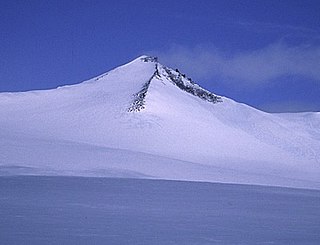
Chaupi Orco or Viscachani is a mountain in the Andes on the border of Bolivia and Peru. It has a height of 6,044 metres (19,829 ft). On the Bolivian side it is located in the La Paz Department, Franz Tamayo Province, Pelechuco Municipality, and on the Peruvian side it lies in the Puno Region, Putina Province, Sina District. It lies north of Salluyu. Chaupi Orco is the highest peak of the Apolobamba mountain range.

The Sinú Valley dry forests (NT0229) is an ecoregion in the north of Colombia.
The Cauca Valley montane forests (NT0109) is an ecoregion in western Colombia. It covers the sides of the Cauca Valley, which runs from south to north between the Central and Western Ranges (cordilleras) of the Colombian Andes. The ecoregion is home to very diverse fauna and flora, due in part to its varied elevations and climates, in part to its position near the isthmus of Panama, the route along which North American species invaded South America and then diversified as they moved to the upper parts of the Andes. Little of the original habitat remains at lower levels, but higher up there are sizeable blocks of forest, some of which are protected.

The Bucaramanga–Santa Marta Fault or Bucaramanga–Santa Marta fault system is a major oblique transpressional sinistral strike-slip fault in the departments of Magdalena, Cesar, Norte de Santander and Santander in northern Colombia. The fault system is composed of two main outcropping segments, the Santa Marta and Bucaramanga faults, and an intermediate Algarrobo Fault segment in the subsurface. The system has a total length of 674 kilometres (419 mi) and runs along an average north-northwest to south-southeast strike of 341 ± 23 from the Caribbean coast west of Santa Marta to the northern area of the Eastern Ranges of the Colombian Andes.

Tamotsu Nakamura, FRGS, is a Japanese explorer, alpinist, photographer and author. Since 1990, he has explored the mountainous areas between the Himalayas and the Sichuan basin; which he documents in photographs. He is a leading authority on the Alps of Tibet, the south-eastern sector of the Tibetan high plateau.
References
- 1 2 2011: Huancasayani Valley, various ascents. http://aaj.americanalpineclub.org/climbs-and-expeditions/south-america/bolivia/cordillera-apolobamba/2011-huancasayani-valley-various-ascents-by-marcin-kruczyk/ Archived 2012-08-26 at the Wayback Machine
- ↑ Conversation with Magdalena Tworek on 31 October 2012.
- ↑ Conversation with Magdalena Tworek on 29 October 2012.