Related Research Articles

Awantipora or Avantipur or Aavantipur, known as Woontpor in Kashmiri, is a town, just opposite of Pulwama city, on the banks of the river Jhelum in the Pulwama district of Jammu and Kashmir, India.

Bijbehara (Urdu pronunciation:[biːd͡ʒbɪɦɑːɽɑː], known as Vejibror in Kashmiri, is a town and a notified area committee in Anantnag district of the Indian administered union territory of Jammu and Kashmir. It is located on NH 44, and jehlum bank. Bijbehara town is also known as "Town of Chinars" because of a number of Chinars there especially two Chinar gardens. Bijbehara is the home to oldest chinar tree in the region. The town is situated about 45 km from the summer capital of union territory of Jammu and Kashmir, Srinagar.
Kulgam, known as Kolgom in Kashmiri, is a town, an administrative division and capital of the Kulgam district in the Indian union territory of Jammu and Kashmir. It is located at a distance of 67 km (42 mi) from the summer state capital of Jammu and Kashmir, Srinagar. The city is divided into 16 electoral wards that has a population of 23,584, of which 12,605 are males while 10,979 are females.

Pahalgam, known as Pahalgom is a town and a notified area committee, near Anantnag city in the Anantnag district of the Indian-administered union territory of Jammu and Kashmir. It is a popular tourist destination and hill station. Its lush green meadows and pristine waters attract thousands of tourists from all over the world each year. It is located 45 kilometres (28 mi) from Anantnag on the banks of Lidder River at an altitude of 7,200 feet (2,200 m). Pahalgam is the headquarters of one of the eleven tehsils of Anantnag district.

Kulgam district is an administrative district of Indian-administered Jammu and Kashmir in the disputed Kashmir region. It is in the Kashmir division and is located at a distance of 18 kilometres (11 mi) towards south-west of Anantnag. The district comprises block, tehsil and town of Kulgam.
Khanabal is a small town located in Anantnag District's Anantnag City. The main National Highway of Kashmir passes through it. It is the center for Anantnag City's Railway Station. Khanabal is situated on both banks of the Jehlum River. The part on the western bank is called Dak Banglow Khanabal, and the part on the eastern bank is called Khanabal Bazaar. The oldest college of the district, Govt. Degree College, Anantnag, is situated on the western bank of the Jehlum River near Dak Banglow Khanabal. Besides, Dak Banglow is an army cantonment area and has a housing colony for the district administrative officers of the police. The district police lines and the office of SSP Anantnag is also situated at Khanabal. Besides the college, Khanabal has a Govt. Higher Secondary School and an army goodwill school run by the Indian Army.
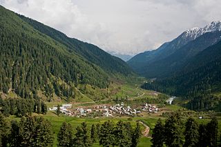
Aru known as Adav in Kashmiri, is a village, tourist spot in the Anantnag District of Jammu and Kashmir, India. It lies 53km from Anantnag city, the district headquarter. It is located around 12 km from Pahalgam, 11 km upstream from the Lidder River. Noted for its scenic meadows, lakes and mountains, it is a base camp for trekking to the Kolhoi Glacier, Tarsar Lake, Marsar and Herbaghwan Lake. The village lies on the left bank of the Aru river, which is a tributary of the Lidder river. Jammu & Kashmir’s biggest Fodder Seed Product Station is also located in the Aru village.
Gantali Pora is a village in Bijbehara tehsil, Anantnag district, of the Indian union territory of Jammu and Kashmir. As of 2011 the village had a population of 713 split into 80 households with males forming 353(49.5%) of the populace and females 360(51.5). Its elevation is approximately 890m above MSL. While Urdu is the official language, Kashmiri is also mostly spoken.

Fatehpora also known as Fateh Pora & Fatehpura, is an economic hub area of Anantnag district in the union territory of Jammu and Kashmir, India. Fatehpora is located at 33.656027°N 75.160375°E. It has an average elevation of 1652 metres (5419 feet) above mean sea level.
Hardu Shichan is a village in Anantnag tehsil in Anantnag district in Jammu and Kashmir, India. It is one of 105 villages in Anantnag block along with villages like Peth Bugh and Dialgam
Dialgam is a large village situated in Anantnag tehsil, in Anantnag district of Jammu and Kashmir. It is one of 150 villages in Anantnag Block along with villages like Hardu Shichan and Pal Pora.
Hutmarah is a village in Anantnag East tehsil in Anantnag district in the Indian union territory of Jammu and Kashmir. It is one of 105 villages in Anantnag East Tehsil Block Mattan along with villages like Seer hamdan and Mattan. It is divided into 9 main parts which are Hargam, Malpora, Nayakpora, Dangerpora, Sikh Mohalla, Peer Mohalla, Nai basti and Noor colony. The village is situated on the banks of Lidder River.Muslims, Hindus and Sikhs live together in this village.Moreover, the entire village lives in peace and harmony and there is no conflict of any kind. Villagers come forward in each other sorrows and happiness and they are of helpful nature.
Isoo is a village in Anantnag tehsils in Anantnag district in Jammu and Kashmir, India.
Sifan is a village in Anantnag tehsil in Anantnag district in Jammu and Kashmir, India.
Shalwan Pora is a village in Anantnag tehsil in Anantnag district in Jammu and Kashmir, India.
Brinty Bat Pora village is located in Anantnag tehsil of Anantnag district in Jammu and Kashmir, India.
Thajiwara is a village in South kashmir in the Anantnag district of the Indian union territory of Jammu and Kashmir. It is located on National Highway 244.

Aglar is a notified area and a town in Zainapora Sub District of Kashmir. It is situated on the left bank of Rambi Ara which demarcates between Pulwama district with Shopian district. Aglar is located 13 km (8.1 mi) towards east from Pulwama, 4 km (2.5 mi) from Zainapora and 18 km (11 mi) towards west from Anantnag. Aglar is 3rd most populous town, located in Zainapora sub district of the state Jammu & Kashmir in India and 3rd biggest town by area in the sub district. The Pin code of Aglar is 192305.
Tail Wani, commonly known as Tailwani, is a village in Anantnag tehsils in Anantnag district, Jammu and Kashmir, India. Tail Wani village is located in Anantnag Tehsil of Anantnag district in Jammu & Kashmir. It is situated 17 km away from Anantnag.
Krewa Rampur is a village in Anantnag tehsil in Anantnag district, Jammu and Kashmir, India. Krewa Rampur village is located in Anantnag Tehsil of Anantnag district in Jammu & Kashmir. It is situated 10 km away from Anantnag.
References
- ↑ "Primary census abstract data". Census of India. Retrieved 22 February 2014. (For villages, select "rural" radio button, then select state, district and sub-district. A drop down list of villages well appear. Select the village.)
24°41′N87°56′E / 24.683°N 87.933°E