
Achabal, known as Achival in Kashmiri, is a town in Anantnag district, in the union territory of Jammu and Kashmir, India.

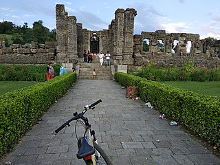
Awantipora or Avantipur or Aavantipur, known as Woontpor in Kashmiri, is a town, just opposite of Pulwama city, on the banks of the river Jhelum in the Pulwama district of Jammu and Kashmir, India.

Bijbehara (Urdu pronunciation:[biːd͡ʒbɪɦɑːɽɑː], known as Vejibror in Kashmiri, is a town and a notified area committee in Anantnag district of the Indian administered union territory of Jammu and Kashmir. It is located on NH 44, and jehlum bank. Bijbehara town is also known as "Town of Chinars" because of a number of Chinars there especially two Chinar gardens. Bijbehara is the home to oldest chinar tree in the region. The town is situated about 45 km from the summer capital of union territory of Jammu and Kashmir, Srinagar.

Ganderbal is a city and the headquarters of Ganderbal district in the Indian-administered union territory of Jammu and Kashmir, in disputed Kashmir region. It is in Central Kashmir; and has an average elevation of 1,619 metres. Ganderbal is bordered by district Srinagar District in the south, Bandipora District to the north, Kargil District in the northeast, Anantnag District to the southeast, and Baramulla District in the southwest. The current District Magistrate of Ganderbal is Shri. Shyambir Singh (IAS) and the current Superintendent of police is Shri. Ragav S. (IPS). Ganderbal is renowned for its beauty, boasting numerous picturesque places and captivating landscapes. Sonamarg is the most famous place in Ganderbal; Shri Amarnath Ji Yatra is also traversed through Ganderbal district. Manasbal Lake famous for natural and purity of water as compared to other water lakes of the Kashmir Valley.
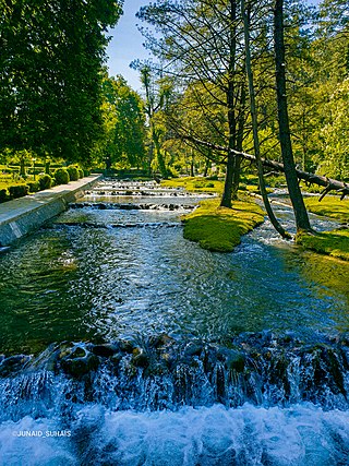
Kokernag is a sub-district town and a notified area committee in Breng Valley, Anantnag district in the Indian union territory of Jammu and Kashmir. The place is known for its botanical gardens, pristine freshwater springs, and rainbow trout farm. It is 25.3 km from Anantnag District via NH244. It is one of the most popular weekend getaways from the state capital of Srinagar.
Kulgam, known as Kolgom in Kashmiri, is a town, an administrative division and capital of the Kulgam district in the Indian union territory of Jammu and Kashmir. It is located at a distance of 67 km (42 mi) from the summer state capital of Jammu and Kashmir, Srinagar. The city is divided into 16 electoral wards that has a population of 23,584, of which 12,605 are males while 10,979 are females.
Mattan is a town, tehsil and a notified area committee, near Anantnag city in the Anantnag district of the Indian union territory of Jammu and Kashmir.

Qazigund, also known as Gateway Of Kashmir, is a town and in the union territory of Jammu and Kashmir, India. Qazigund is located at 33.59°N 75.16°E. It has an average elevation of 1670 m (5478 feet) above mean sea level.
Qaimoh is a block, a town and a notified area committee in Kulgam District in the union territory of Jammu and Kashmir, India. It is four miles to the west of Anantnag and six miles to the north of Kulgam District. It is 55 km to the south of Srinagar city. Qaimoh is one of the largest blocks in Jammu and Kashmir.

Fatehpora also known as Fateh Pora & Fatehpura, is an economic hub area of Anantnag district in the union territory of Jammu and Kashmir, India. Fatehpora is located at 33.656027°N 75.160375°E. It has an average elevation of 1652 metres (5419 feet) above mean sea level.
Dialgam is a large village situated in Anantnag tehsil, in the Anantnag district of the Kashmir Valley of Jammu and Kashmir, India. It is one of 150 villages in Anantnag Block along with villages like Hardu Shichan and Pal Pora.

Akingam is a village in South Kashmir in the Anantnag district, in the Indian union territory of Jammu and Kashmir. It is at a distance of approximately 14.2 kilometres (8.8 mi) from the Lal Chowk along a route passing through the tourist resorts of Achabal and Kokernag. In revenue records, the village of Akingam is still called Maqan Shiva Bhagwati. The adjacent villages are Mohripura, Hiller, Badasgam, Hardpora and Badoora.
Shankerpora, also known as Shankerpur, is a village in Anantnag district in the Indian-administered union territory of Jammu and Kashmir.

Padgampora, also known as Padgampur, is a village in Awantipora tehsil in Pulwama district of Indian administered Jammu and Kashmir. It is located 14 km (8.7 mi) towards East from District headquarters Pulwama. 14 km (8.7 mi) from Tral. 25 km from State capital Srinagar.
Gadiseer is a village in the Anantnag district in the Indian administered union territory of Jammu and Kashmir. It is located on the bank of Jhelum River. PIN code of Gadiseer is 192124 and its postal head office is Bijbehara. The village falls in the vicinity (jurisdiction) of tehsil Bijbehara in Dachnipora Block.
Tail Wani, commonly known as Tailwani, is a village in Anantnag tehsils in Anantnag district, Jammu and Kashmir, India. Tail Wani village is located in Anantnag Tehsil of Anantnag district in Jammu & Kashmir. It is situated 17 km away from Anantnag.
Hardu Toru, commonly known as Toor, is a village in Anantnag tehsils in Anantnag district, Jammu and Kashmir, India. Hardu Toru village is located in Anantnag Tehsil of Anantnag district in Jammu & Kashmir. It is situated 17 km away from Anantnag.
Magri Pora is a village in Anantnag tehsil of Anantnag district in the Kashmir Valley of Jammu and Kashmir, India. Magri Pora is situated 8 km away from the city of Anantnag.
Devi Pora, commonly known as Devipora, is a village in the Anantnag tehsil of Anantnag district in the Kashmir Valley of Jammu and Kashmir, India. It is situated 17 km away from the town of Achabal.
Krewa Rampur is a village in Anantnag tehsil in Anantnag district, Jammu and Kashmir, India. Krewa Rampur village is located in Anantnag Tehsil of Anantnag district in Jammu & Kashmir. It is situated 10 km away from Anantnag.

