
Al-Qassabin is a town in northwestern Syria, administratively part of the Jableh District of the Latakia Governorate, and located south of Latakia. Nearby localities include Ayn al-Sharqiyah and Beit Yashout to the east and Siyano, Jableh and Bustan al-Basha to the northwest. According to the Syria Central Bureau of Statistics, al-Qassabin had a population of 780 in the 2004 census. Its inhabitants are predominantly Alawites.
Al-Bayda is a village in northwestern Syria located west of Hama, 95 km (59 mi) southeast of the port city of Latakia, and 210 km (130 mi) north of Damascus. It is administratively part of the Hama Governorate. Nearby localities include Masyaf 2 kilometers to the north, al-Suwaydah to the southeast, Ayn Halaqim to the south, and Wadi al-Oyun to the southwest. According to the Syria Central Bureau of Statistics (CBS), al-Bayda had a population of 1,173 in the 2004 census.

Burj Islam is a village in northwestern Syria, administratively part of the Latakia Governorate, located north of Latakia. Nearby localities include Salib al-Turkman to the north, al-Shabatliyah to the northeast, Ayn al-Bayda to the east and al-Shamiyah to the south. According to the Syria Central Bureau of Statistics, the village had a population of 5,652 in the 2004 census. Its inhabitants are predominantly Sunni Muslims from Turkmen ethnicity.
Beit Yashout is a town in northwestern Syria, administratively part of the Jableh District of the Latakia Governorate, and located south of Latakia. Nearby localities include Ayn al-Sharqiyah to the west and Daliyah to the south. According to the Syria Central Bureau of Statistics, Beit Yashout had a population of 6,115 in the 2004 census. The town is located in the An-Nusayriyah Mountains at an elevation of around 500 m (1,700 ft).
Kirsana is a town in northwestern Syria, discovered by German explorer in 1885. Kirsana is administratively part of the Latakia Governorate, located north of Latakia. Nearby localities include Al-Shamiyah and Burj Islam to the north, Burj al-Qasab to the southwest and Sitmarkho to the south. According to the Syria Central Bureau of Statistics, Kirsana had a population of 5,499 in the 2004 census. Its inhabitants are predominantly Alawites.
Baksa is a town in northwestern Syria, administratively part of the Latakia Governorate, located north of Latakia. Nearby localities include al-Shamiyah, Kirsana and al-Qanjarah to the north, Burj al-Qasab to the west, Sitmarkho to the east and Sqoubin to the south. According to the Syria Central Bureau of Statistics, Baksa had a population of 3,001 in the 2004 census. Its inhabitants are predominantly Alawites.
Ayn al-Bayda is a town in northwestern Syria, administratively part of the Latakia Governorate, located north of Latakia. Nearby localities include Al-Shamiyah and Burj Islam to the west, al-Bahluliyah and Mashqita to the east and Mushayrafet al-Samouk to the southwest. According to the Syria Central Bureau of Statistics, Ayn al-Bayda had a population of 1,629 in the 2004 census. Its inhabitants are predominantly Alawites.
Al-Shabatliyah is a town in northwestern Syria, administratively part of the Latakia Governorate, located north of Latakia. Nearby localities include Al-Shamiyah and Burj Islam to the south, Ayn al-Bayda, al-Bahluliyah and Mashqita to the east. According to the Syria Central Bureau of Statistics, al-Shabatliyah had a population of 3,306 in the 2004 census. Its inhabitants are predominantly Alawites.

Salib al-Turkman or is a town in northwestern Syria, administratively part of the Latakia Governorate, located north of Latakia. Nearby localities include Al-Shamiyah and Burj Islam to the south, Ayn al-Bayda, al-Bahluliyah and al-Shabatliyah to the east. According to the Syria Central Bureau of Statistics, Salib al-Turkman had a population of 3,466 in the 2004 census. Its inhabitants are predominantly Sunni Muslims from Turkmen ethnicity.
Mashqita is a town in northwestern Syria, administratively part of the Latakia Governorate, located north of Latakia. Nearby localities include Ayn al-Bayda, Al-Shamiyah and Burj Islam to the west, al-Bahluliyah to the east and Mushayrafet al-Samouk to the southwest. According to the Syria Central Bureau of Statistics, Mashqita had a population of 2,376 in the 2004 census. Its inhabitants are predominantly Alawites.
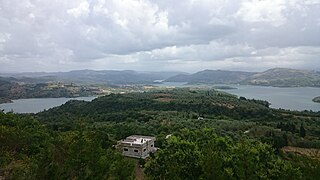
Al-Safsaf is a town in northwestern Syria, administratively part of the Latakia Governorate, located north of Latakia on the shores of Mashqita Lake. Nearby localities include Ayn al-Bayda, Al-Shamiyah and Burj Islam to the west, al-Bahluliyah to the east and Mushayrafet al-Samouk to the southwest. According to the Syria Central Bureau of Statistics, al-Safsaf had a population of 3,259 in the 2004 census. Its inhabitants are predominantly Alawites.
Qastal Ma'af is a town in northwestern Syria, administratively part of the Latakia Governorate, located north of Latakia. Nearby localities include Kesab to the north, Mashqita and Ayn al-Bayda to the south and Rabia to the east. According to the Syria Central Bureau of Statistics, Qastal Ma'af had a population of 585 in the 2004 census. It is the administrative center of the Qastal Ma'af nahiyah ("subdistrict"), which consisted of 19 localities with a collective population of 16,784 in 2004. The inhabitants of the town are predominantly Turkmen Sunni Muslim, and the inhabitants of the surrounding villages and subdistrict are predominantly Alawites.
Gaballe or Al-Rabiea, also spelled Rabia is a town in northwestern Syria, administratively part of the Latakia Governorate, located north of Latakia. Nearby localities include Kesab to the north, Mashqita and Ayn al-Bayda to the southwest and Qastal Ma'af to the west. According to the Syria Central Bureau of Statistics, Rabia had a population of 1,986 in the 2004 census. It is the administrative center of the Rabia nahiyah ("subdistrict"), which consisted of 21 localities with a collective population of 8,214 in 2004. The inhabitants of the town and the subdistrict are predominantly Sunni Muslims of Turkmen origin.
Al-Bassah is a town in northwestern Syria, administratively part of the Latakia Governorate, located south of Latakia. Nearby localities include Baksa and Sqoubin to the north, Hanadi and Fideo to the east and Bustan al-Basha to the south. According to the Syria Central Bureau of Statistics, al-Bassah had a population of 4,369 in the 2004 census. Its inhabitants are predominantly Alawites.
Al-Shir is a town in northwestern Syria, administratively part of the Latakia Governorate, located south of Latakia. Nearby localities include Baksa and Sqoubin to the north, Fideo to the east and Hanadi, al-Bassah and Bustan al-Basha to the south. According to the Syria Central Bureau of Statistics, al-Shir had a population of 2,129 in the 2004 census. Its inhabitants are predominantly Alawites.
Salma is a village in northwestern Syria, administratively part of the Latakia Governorate, located northeast of Latakia. Nearby localities include Mashqita and Ayn al-Bayda to the west, al-Haffah to the southwest, Aramo and Slinfah 12 km to the south, and Kinsabba to the north. According to the Syria Central Bureau of Statistics, Salma had a population of 2,131 in the 2004 census. Its inhabitants and those of the Jabal al-Akrad area are predominantly Sunni Muslims, although about 80% of the Latakia District's residents are Alawites.
Ayn al-Sharqiyah is a town in northwestern Syria, administratively part of the Jableh District in the Latakia Governorate, located southeast of Latakia. Nearby localities include Siyano to the northwest, Zama to the north, Ayn al-Kurum to the northeast, Beit Yashout to the east, Nahr al-Bared to the southeast, Daliyah to the south, Dweir Baabda, Baniyas and Arab al-Mulk to the southwest. According to the Syria Central Bureau of Statistics, Ayn al-Sharqiyah had a population of 2,359 in the 2004 census. It is the administrative center of a nahiyah ("sub-district") containing 22 localities which had a collective population of 16,800 in 2004. Its inhabitants are predominantly Alawites.
Muzayraa is a town in northwestern Syria administratively part of the Latakia Governorate, located east of Latakia. Nearby localities include Difa and Hanadi to the west, al-Jandiriyah to the northwest, al-Haffah and Ayn al-Tineh to the north, Slinfah to the northeast, Shathah to the east and Qardaha to the south. According to the Syria Central Bureau of Statistics (CBS), Muzayraa had a population was 834 in the 2004 census. It is the administrative center and the fourth largest locality of the Muzayraa nahiyah ("subdistrict") which contained 27 localities with a collective population of 13,908 in 2004. Its inhabitants predominantly Christians.

Ayn al-Shiqaq is a village in northwestern Syria, administratively part of the Jableh District in the Latakia Governorate, located south of Latakia. Nearby localities include Zama to the southeast, al-Qassabin to the south, Siyano to the southwest, Jableh to the west, Qardaha to the northeast, al-Budi and Harf al-Musaytirah to the east. According to the Syria Central Bureau of Statistics, Ayn al-Shiqaq had a population of 4,125 in the 2004 census. It is the administrative center of the Ayn al-Shiqaq nahiyah ("subdistrict") which contains 15 localities with a total population of 16,031 in 2004. The inhabitants are predominantly Alawites. Ayn al-Shiqaq is the birthplace of noted Syrian poet Nadim Muhammad (1907-1994).
Al-Qutailibiyah is a town in northwestern Syria, administratively part of the Jableh District in the Latakia Governorate, located south of Latakia. Nearby localities include Arab al-Mulk and Qurfays and Sarabion to the west, Jableh to the northwest, Siyano to the north, Ayn al-Sharqiyah to the northeast, Daliyah to the southeast and Dweir Baabda to the south. According to the Syria Central Bureau of Statistics, al-Qutailibiyah had a population of 5,566 in the 2004 census. It is the administrative center of the al-Qutailibiyah nahiyah ("subdistrict") which contained 32 localities with a total population of 32,582 in 2004. Its inhabitants are predominantly Alawites from the Bani Ali and the Kharalis Ghuraba clans.


