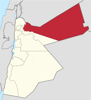
Mafraq is one of the governorates of Jordan, located to the north-east of Amman, capital of Jordan. It has a population of 287,300 making up 4.5% of Jordan's population. Its capital is Mafraq, which is known for its military bases.

Bayt Nabala or Beit Nabala was a Palestinian Arab village in the Ramle Subdistrict in Palestine that was destroyed during the 1948 Arab–Israeli War. The village was in the territory allotted to the Arab state under the 1947 UN Partition Plan. Its population in 1945, before the war, was 2,310.

Bayt Tima was a Palestinian Arab village in the Gaza Subdistrict, located 21 kilometers (13 mi) northeast of Gaza and some 12 kilometers (7.5 mi) from the coastline. It was situated in flat terrain on the southern coastal plain of Palestine. Bayt Tima was depopulated during the 1948 Arab-Israeli War. Its population in 1945 was 1,060.
Bayt 'Affa was a Palestinian village in the Gaza Subdistrict. It was depopulated and destroyed during the 1947–48 Civil War in Mandatory Palestine. It was located 29 km northeast of Gaza and Wadi al-Rana ran east of the village.
Bayt Thul was a Palestinian village in the Jerusalem Subdistrict. It was depopulated during the 1947–1948 Civil War in Mandatory Palestine on April 1, 1948 under Operation Nachshon. It was located 15.5 km west of Jerusalem.
Bayt Shanna was a Palestinian Arab village in the Ramle Subdistrict of Mandatory Palestine. It was depopulated during the 1948 Arab–Israeli War on July 15, 1948, during the second stage of Operation Dani. It was located 11.5 km southeast of Ramla.

Bayt Susin was a Palestinian Arab village in the Ramle Subdistrict of Mandatory Palestine, located 17 kilometers (11 mi) southeast of Ramla. In 1945, it had 210 inhabitants. The village was depopulated during the 1948 war by the Israeli 7th Brigade.

Beit Jinn, also known as Bayt Jin, Beit Jann or Beyt Jene, is a town in southern Syria, administratively part of the Rif Dimashq Governorate, located southwest of Damascus on the foothills of Mount Hermon. According to the Syria Central Bureau of Statistics, Beit Jinn had a population of 2,846 in the 2004 census. Its inhabitants are predominantly Sunni Muslims.
Beit Sawa is a village in southern Syria, administratively part of the Markaz Rif Dimashq District of the Rif Dimashq Governorate, located just east of Damascus. Nearby localities include Hammurah and Saqba to the south, Arbin to the west, Mesraba and Douma to the north. According to the Syria Central Bureau of Statistics (CBS), Beit Sawa had a population of 6,249 in the 2004 census.
Husayn al-Baher is a village in northwestern Syria, administratively part of the Tartus Governorate, located north of Tartus. Nearby localities include Maten al-Sahel to the north, Annazah to the northeast, al-Sawda to the east, Awaru and Khirbet al-Faras to the southeast and Dweir al-Shaykh Saad to the south. According to the Syria Central Bureau of Statistics, Husayn al-Baher had a population of 4,350 in the 2004 census, making it the largest locality of the al-Sawda nahiyah ("sub-district"). The inhabitants of the village are predominantly Alawites.
Beit Sahem is a village in southern Syria, administratively part of the Markaz Rif Dimashq District of the Rif Dimashq Governorate, located Damascus's southeastern outskirts. Nearby localities include Babbila to the west, Jaramana to the north, Aqraba east and Sayyidah Zaynab to the south. According to the Syria Central Bureau of Statistics (CBS), Beit Sahem had a population of 15,667 in the 2004 census.
Mazraat Beit Jen, also known as Mazraat Beit Jinn or Mazraat Bayt Jinn, is a Syrian village in the Qatana District of the Rif Dimashq Governorate. According to the Syria Central Bureau of Statistics (CBS), Mazraat Beit Jen had a population of 5,073 in the 2004 census.

Wadi al-Uyun Subdistrict is a Syrian nahiyah (subdistrict) located in Masyaf District in Hama. According to the Syria Central Bureau of Statistics (CBS), Wadi al-Uyun Subdistrict had a population of 12951 in the 2004 census.
Bayt Natar is a Syrian village located in the Ayn Halaqim Subdistrict of the Masyaf District in Hama Governorate. According to the Syria Central Bureau of Statistics (CBS), Bayt Natar had a population of 1,304 in the 2004 census. Its inhabitants are predominantly Turkmens.
Hikr Bayt Atiq is a Syrian village located in Ayn Halaqim Nahiyah in Masyaf District, Hama. According to the Syria Central Bureau of Statistics (CBS), Hikr Bayt Atiq had a population of 336 in the 2004 census.
Bayt Atiq is a Syrian village located in the Ayn Halaqim Subdistrict in Masyaf District, located southwest of Hama. According to the Syria Central Bureau of Statistics (CBS), Bayt Atiq had a population of 488 in the 2004 census. In the 1960s, it was described as a small village.
Bayt Raqtah is a Syrian village located in Wadi al-Uyun Nahiyah in Masyaf District, Hama. According to the Syria Central Bureau of Statistics (CBS), Bayt Raqtah had a population of 265 in the 2004 census.
Al-Shajara is a town in southern Syria, administratively part of the Daraa Governorate, located west of Daraa, in between the Israeli-occupied Golan Heights and Jordan. Nearby localities include Saham al-Jawlan to the east, Nafia to the north, Jamla to the northwest and Bayt Ara to the southwest.
Baydar Rafi'ah is a village in northern Syria located west of Homs in the Homs Governorate. According to the Syria Central Bureau of Statistics, Baydar Rafi'ah had a population of 1,206 in the 2004 census. Its inhabitants are predominantly Greek Orthodox Christians.
Bayt al-Shaykh Yunis is a village in northwestern Syria, administratively part of the Tartus Governorate. It is located between Safita and Ras al-Khashufah. According to the Syria Central Bureau of Statistics (CBS), Bayt al-Shaykh Yunis had a population of 2,199 in the 2004 census. Its inhabitants are predominantly Alawites.


