
Yemen, officially the Republic of Yemen, is a country in West Asia. Located in southern Arabia, it borders Saudi Arabia to the north, Oman to the northeast, the Red Sea to the west, and the Indian Ocean to the south, sharing maritime borders with Eritrea, Djibouti and Somalia across the Horn of Africa. Covering roughly 455,000 square kilometres, with a coastline of approximately 2,000 kilometres, Yemen is the second largest country on the Arabian Peninsula. Sanaa is its constitutional capital and largest city. Yemen's estimated population is 34.7 million, mostly Arab Muslims. It is a member of the Arab League, the United Nations, the Non-Aligned Movement and the Organisation of Islamic Cooperation.

Marib is a governorate of Yemen. It is located 173 kilometers to the northeast of Yemen's capital, Sana'a. The population of Marib Governorate comprises 1.2% of the country's total population. The city of Marib is the capital of the governorate, and was established after the discovery of oil deposits in 1984. The total number of residents living in the governorate was 238,522, according to the 2004 census, and the rate of growth was 2.72%.

Saada or Sa'dah is one of the governorates of Yemen. The governorate's seat and the largest city is Saada. It is the epicentre of Zaydism and where the Houthi group originates from.
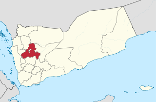
Sanaa, also spelled San'a' or Sana, is a governorate of Yemen. Its capital is Sanaa, which is also the national capital. However, the city of Sanaa is not part of the governorate but instead forms the separate governorate of Amanat Al-Asemah. The Governorate covers an area of 13,850 km2 (5,350 sq mi). As of 2004, the population was 2,918,379 inhabitants. Within this place is Jabal An-Nabi Shu'ayb or Jabal Hadhur, the highest mountain in the nation and the Arabian Peninsula.

Anwar Nasser Abdulla al-Awlaki was an American-Yemeni lecturer and jihadist who was killed in 2011 in Yemen by a U.S. government drone strike ordered by President Barack Obama. Al-Awlaki became the first U.S. citizen to be targeted and killed by a drone strike from the U.S. government. U.S. government officials have claimed that al-Awlaki was a key organizer for the Islamist militant group al-Qaeda.

The Houthi insurgency, also known as the Houthi rebellion, the Sa'dah Wars, or the Sa'dah conflict, was a military rebellion pitting Zaidi Shia Houthis against the Yemeni military that began in Northern Yemen and has since escalated into a full-scale civil war. The conflict was sparked in 2004 by the government's attempt to arrest Hussein Badreddin al-Houthi, a Zaidi religious leader of the Houthis and a former parliamentarian on whose head the government had placed a $55,000 bounty.
Judeo-Yemeni Arabic is a variety of Arabic spoken by Jews living or formerly living in Yemen. The language is quite different from mainstream Yemeni Arabic, and is written in the Hebrew alphabet. The cities of Sana'a, Aden, al-Bayda, and Habban District and the villages in their districts each have their own dialect.

Al-Qaeda in the Arabian Peninsula, or AQAP is a Sunni Islamist militant organization which seeks to overthrow the Yemeni government and establish an Islamic emirate. Part of the al-Qaeda network, the group is based and primarily active in Yemen, while also conducting operations in Saudi Arabia. It is considered the most active of al-Qaeda's affiliates that emerged after the weakening of central leadership.

Sanaa, officially the Sanaa Municipality, is the capital and largest city of Yemen. The city is the capital of the Sanaa Governorate, but is not part of the governorate, as it forms a separate administrative unit. According to the Yemeni constitution, Sanaa is the capital of the country, although the seat of the Yemeni government moved to Aden, the former capital of Democratic Yemen, in the aftermath of the Houthi occupation. Aden was declared the temporary capital by then-president Abdrabbuh Mansur Hadi in March 2015.
Operation Scorched Earth was the code-name of a Yemeni military offensive in the Saada Governorate that began in August 2009. It marked the fifth wave of violence during the ongoing insurgency by the Houthis against the government. In November 2009, the conflict spread across the border into neighboring Saudi Arabia. This conflict led to the Saudi military's incursion into Yemen, marking the first military operation conducted by Saudi Arabia since 1991.
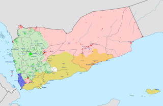
The South Yemen insurgency is a term used by the Yemeni government to describe the protests and attacks on government forces in southern Yemen, ongoing since 27 April 2009. Although the violence has been blamed on elements within the southern secessionist movement, leaders of the group maintain that their aims of independence are to be achieved through peaceful means, and claim that attacks are from ordinary citizens in response to the government's provocative actions. The insurgency comes amid the Shia insurgency in the country's north as led by the Houthi communities. Southern leaders led a brief, unsuccessful secession in 1994 following unification. Many of them are involved in the present secession movement. Southern separatist insurgents are active mainly in the area of former South Yemen, but also in Ad Dali' Governorate, which was not a part of the independent southern state. They are supported by the United Arab Emirates, even though the UAE is a member of the Saudi Arabian-led coalition working to support the Yemeni government.
The Al-Qaeda insurgency in Yemen is an ongoing armed conflict between the Yemeni government, the United States and their allies, and al-Qaeda-affiliated groups in Yemen. It is a part of the Global War on Terror.

The Southern Movement, sometimes known as the Southern Separatist Movement, or South Yemen Movement, or Aden Movement, and colloquially known as al-Hirak, is a political movement and paramilitary organization active in the south of Yemen since 2007, demanding secession from the Republic of Yemen and a return to the former independent state of South Yemen. At present, its best-known political offshoot, the Southern Transitional Council led by Aidarus al-Zoubaidi, is the de facto leadership across many provinces of the south.

Al Wade'a District is a district of the Abyan Governorate, Yemen. As of 2003, the district had a population of 23,400 inhabitants. The former president of Yemen Abdrabbuh Mansur Hadi comes from Thukain, which lies in Al Wade'a District.
Al Mashannah District is a district of the Ibb Governorate, Yemen. As of 2003, the district had a population of 101,148 inhabitants.
Al Udayn District is a district of the Ibb Governorate, Yemen. As of 2003, the district had a population of 143,578 inhabitants.
Dhi As Sufal District is a district of the Ibb Governorate, Yemen. As of 2003, the district had a population of 163,019 inhabitants.
Al Misrakh District is a district of the Taiz Governorate, Yemen. As of 2003, the district had a population of 112,653 inhabitants.

Bani Matar District is a district of the Sanaa Governorate, Yemen. As of 2003, the district had a population of 100,012 inhabitants.
Sanhan and Bani Bahlul District is a district of the Sana'a Governorate, Yemen. Its seat is Sanhan. As of 2003, the district had a population of 400,399 inhabitants. The former President of Yemen Ali Abdullah Saleh comes from Beit al-Ahmar, which lies in Sanhan District.
