
The Arctic Archipelago, also known as the Canadian Arctic Archipelago, is an archipelago lying to the north of the Canadian continental mainland, excluding Greenland and Iceland

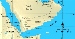
Al Hudaydah is a governorate of Yemen. Its capital is Al Hudaydah. The governorate is also sometimes referred to as the Western Coast. With an estimated population of nearly 4 million, it is the third-most populous governorate in Yemen, behind Ibb and Taiz.
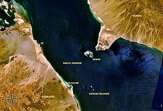
The Bab Iskender (Arabic: باب اسكندر Iskander's Strait, also variously known as the Eastern strait, the small strait, the narrow pass or the small pass, is the eastern section of the Bab-el-Mandeb straits, which separates Ras Menheli, Yemen, on the Arabian Peninsula from Ras Siyyan, Djibouti, on the Horn of Africa. The strait is 2 miles wide and 16 fathoms deep. The Yemeni island of Perim divides the strait into two channels, Bab Iskender and Dact-el-Mayun respectively.
Al Qaflah District is a district of the 'Amran Governorate, Yemen. As of 2003, the district had a population of 36,722 inhabitants.
Suwayr District is a district of the 'Amran Governorate, Yemen. As of 2003, the district had a population of 20,854 inhabitants.
Jayshan District is a district of the Abyan Governorate, Yemen. As of 2003, the district had a population of 14,800 inhabitants.
As Salif District is a district of the Al Hudaydah Governorate, Yemen. As of 2003, the district had a population of 6,343 inhabitants.
Az Zuhrah District is a district of the Al Hudaydah Governorate, Yemen. As of 2003, the district had a population of 138,045 inhabitants.
Zabid District is a district of the Al Hudaydah Governorate in western Yemen.
Harad District is a district of the Hajjah Governorate, Yemen. As of 2003, the district had a population of 93,523 inhabitants.
Midi District is a district of the Hajjah Governorate, Yemen. As of 2003, the district had a population of 16,604 inhabitants.
Mustaba District is a district of the Hajjah Governorate, Yemen. As of 2003, the district had a population of 42,531 inhabitants.
Qarah District is a district of the Hajjah Governorate, Yemen. As of 2003, the district had a population of 30,641 inhabitants.
Washhah District is a district of the Hajjah Governorate, Yemen. As of 2003, the district had a population of 62,617 people.
Bilad At Ta'am District is a district of the Raymah Governorate, Yemen. As of 2003, the district had a population of 31,143 inhabitants.
Kusmah District is a district of the Raymah Governorate, Yemen. As of 2003, the district had a population of 74,622 inhabitants.
Mahliyah District is a district of the Ma'rib Governorate, Yemen. As of 2003, the district had a population of 9,156 inhabitants.
Sahar District is a district of the Sa'dah Governorate, Yemen. As of 2003, the district had a population of 133,060 people.
Sa'fan District is a district of the Sana'a Governorate, Yemen. As of 2003, the district had a population of 33,722 inhabitants.
Bukovik is a village in the municipality of Prijepolje, Serbia. According to the 2002 census, the village has a population of 107 people.
