
NGC 3603 is a nebula situated in the Carina–Sagittarius Arm of the Milky Way around 20,000 light-years away from the Solar System. It is a massive H II region containing a very compact open cluster HD 97950.

Dhale is one of the Yemeni governorates that was created after the unification of Yemen. The population of the province accounts for 2% of the total population of the republic. The governorate is divided into 9 districts. The city of Dhale is the administrative centre of the province. Dali is one of the governorates that is known for agriculture, and most of the population works in that industry. The most important agricultural crop is coffee. The province also contains mineral resources, most importantly talc, which is used in the manufacture of paper, paint, cosmetics and pesticides. This governorate is also home to the Damt hot-springs (Ḥamam-Damt), a popular tourist attraction. One of the ancient cities in the region is Juban, a city famous for its castle and the historic Mansuria school, built by the Tahrids. The climate in Dhale governorate is mostly temperate throughout the year.

Hajjah is a governorate of Yemen in the north-western part of the country. It borders the Red Sea to the west, and its capital is also named Hajjah.

Raymah is a governorate of Yemen. Its capital is Al Jabin. The governorate was established in January 2004 from parts of Sanaa Governorate. Its name derives from Wadi Rima, which crosses through the governorate.
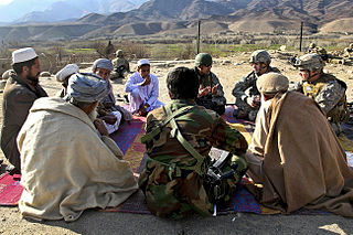
Alingar District is located approximately 27 km from Mehtarlam, the provincial capital of Laghman Province and borders with Alishing and Dawlat Shah districts to the West, Nuristan Province to the North, Kunar and Nangarhar provinces to the East and Qarghayi and Mihtarlam districts to the South.It has about 60 villages located in four main valleys. The population is 85,600 (2006) - 70% of them Pashtun, 20% Pashai and 5% Tajik. The district center is the village of Shahi, located on 34.8347°N 70.3603°E at 915 m altitude, in the valley of the Alingar River, which crosses the district and is the main source of irrigation. The security situation is reported to be relatively stable, although there are some private disputes. The district is reported free of landmines.
Kharif District is a district of the 'Amran Governorate, Yemen. As of 2003, the district had a population of 45,977 inhabitants. On July 13, 2020, it is reported that the Houthi militia captured the last Jews of Yemen in the Kharif District.
Alluheyah District is a district of the Al Hudaydah Governorate, Yemen. As of 2003, the district had a population of 105,682 inhabitants.
As Salif District is a district of the Al Hudaydah Governorate, Yemen. As of 2003, the district had a population of 6,343 inhabitants.
Huraidhah District is a district of the Hadhramaut Governorate, Yemen. As of 2021, the district had a population of 26,340 inhabitants.
Rakhyah District is a district of the Hadhramaut Governorate, Yemen. As of 2021, the district had a population of 13,466 inhabitants.
Sah District is a district of the Hadhramaut Governorate, Yemen. In 2021, the district had a population of 37,210.
Sayun District is a district of the Hadhramaut Governorate, Yemen. As of 2003, the district had a population of 102,409 inhabitants.
Hawrah District is a district of the Hadhramaut Governorate, Yemen. As of 2003, the district had a population of 28,474 inhabitants.
Sanhan and Bani Bahlul District is a district of the Sana'a Governorate, Yemen. Its seat is Sanhan. As of 2003, the district had a population of 400,399 inhabitants. The former President of Yemen Ali Abdullah Saleh comes from Beit al-Ahmar, which lies in Sanhan District.

Habban District is a district of the Shabwah Governorate in Yemen. As of 2003, the district had a population of 29,846 inhabitants. The district takes its name after the town Habban which lies in As Said District, located at 14o21'N. latitude, 47o04'E. longitude. The town is some 275 km east by northeast of Aden by air, some 75 km inland from the Gulf of Aden.
Djèrègbé is an arrondissement in the Ouémé department of Benin. It is an administrative division under the jurisdiction of the commune of Sèmè-Kpodji. According to the population census conducted by the Institut National de la Statistique Benin on February 15, 2002, the arrondissement had a total population of 10,527.
Tohouè is an arrondissement in the Ouémé department of Benin. It is an administrative division under the jurisdiction of the commune of Sèmè-Kpodji. According to the population census conducted by the Institut National de la Statistique Benin on February 15, 2002, the arrondissement had a total population of 17,652.
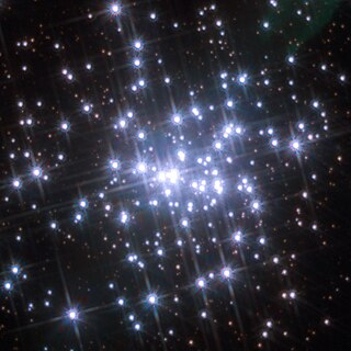
NGC 3603-C is a single-lined spectroscopic binary star system located at the centre of the HD 97950 cluster in the NGC 3603 star-forming region, about 25,000 light years from Earth. The primary has spectral type WN6h and is among the most luminous and most massive known.
WR 42e is a Wolf–Rayet star in the massive H II region NGC 3603 in the constellation of the Carina. It is around 25,000 light-years or 7,600 parsec from the Sun. WR 42e is one of the most massive and most luminous stars known.

Unipouheos 121 is an Indian reserve of the Frog Lake First Nation in Alberta, located within the Municipal District of Bonnyville No. 87 and the County of St. Paul No. 19. It is 32 kilometres southeast of Bonnyville. In the 2016 Canadian Census, it recorded a population of 909 living in 205 of its 232 total private dwellings.
