Alberta Coal Branch

Last updated
Alberta Coal Branch
Overview
TypeBranch
SystemCanadian National Railway
StatusOpen
LocaleYellowhead County
TerminiAlberta Highway 16
Brazeau River
Services2
Operation
Opened1912 (1912)
Technical
Line length57 mi (92 km)
Track gauge 4 ft 8 12 in (1,435 mm) standard gauge
Canada Alberta relief location map.jpg
Red pog.svg
Alberta Coal Branch
Location of the Coal Branch in Alberta

The Alberta Coal Branch is the name given to a segment of the Canadian National Railway (originally the Grand Trunk Pacific Railway) and the region through which it passes. It is located within Yellowhead County in west-central Alberta, Canada.

Canadian National Railway railway company

Canadian National is a Canadian Class I freight railway headquartered in Montreal, Quebec that serves Canada and the Midwestern and Southern United States.

Grand Trunk Pacific Railway transport company

The Grand Trunk Pacific Railway was a historical Canadian transcontinental railway running from Winnipeg to the Pacific coast at Prince Rupert, British Columbia. East of Winnipeg the line continued as the National Transcontinental Railway (NTR), running across northern Ontario and Quebec, crossing the St. Lawrence River at Quebec City and ending at Moncton, New Brunswick. The Grand Trunk Railway (GTR) managed and operated the entire line.

Yellowhead County Municipal district in Alberta, Canada

Yellowhead County is a municipal district in west central Alberta, Canada.

Contents

Geography

The Coal Branch region encompasses a portion of the eastern slopes and foothills of the Canadian Rockies east of Jasper National Park. It extends from Alberta Highway 16 in the north to the Brazeau River in the south. The McLeod, Lovett and Embarras Rivers flow through it, and it includes many former coal-mining towns and ghost towns. [1] [ page needed ]

Canadian Rockies mountain range in Canada

The Canadian Rockies or Canadian Rocky Mountains comprise the Canadian segment of the North American Rocky Mountains. They are the eastern part of the Canadian Cordillera, which is a system of multiple ranges of mountains which runs from the Canadian Prairies to the Pacific Coast. The Canadian Rockies mountain system comprises the southeastern part of this system, lying between the Interior Plains of Alberta and northeastern British Columbia on the east to the Rocky Mountain Trench of BC on the west. The southern end borders Idaho and Montana of the United States. In geographic terms, the boundary is at the Canada–United States border, but in geological terms it might be considered to be at Marias Pass in northern Montana. The northern end is at the Liard River in northern British Columbia.

Jasper National Park national park in the Canadian Rockies

Jasper National Park is the largest national park in the Canadian Rockies, spanning 11,000 km2 (4,200 sq mi). It is located in the province of Alberta, north of Banff National Park and west of Edmonton. The park contains the glaciers of the Columbia Icefield, springs, lakes, waterfalls and mountains.

Alberta Highway 16 highway in Alberta

Alberta Provincial Highway No. 16, commonly referred to as Highway 16, is a major east–west highway in central Alberta, Canada, connecting Jasper to Lloydminster via Edmonton. It forms a portion of the Yellowhead Highway, a major interprovincial route of the Trans-Canada Highway system that stretches from Masset, British Columbia to Portage la Prairie, Manitoba, near Winnipeg. Highway 16 spans approximately 634 km (394 mi) from Alberta's border with British Columbia in the west to its border with Saskatchewan in the east. As of 2010, all but less than 96 km (60 mi) of the route was divided, with a minimum of two lanes in each direction. It is designated a core route in Canada's National Highway System.

History

The Coal Branch rail line was built between 1911 and 1912 by the Grand Trunk Pacific Railway to gain access to deposits of high-quality steam coal. It diverges from the main line at Bickerdike and runs south through Coalspur to the Lovett River, a distance of 57 miles (90 km). A series of coal mining, railroad, and logging towns quickly developed along the route. Going south from Bickerdike, they include McLeod River, Erith, Weald, Embarras, Robb, Coalspur, Diss, Sterco, Foothills and Lovetteville. [2] [ page needed ]

Coalspur is a nearly abandoned coal-mining and railroad town in Yellowhead County, Alberta. It is situated on Highway 47 beside the Embarras River in the foothills of the Canadian Rockies.

Robb, Alberta Hamlet in Alberta, Canada

Robb is a hamlet in west-central Alberta, Canada within Yellowhead County. It is located on Highway 47, approximately 53 kilometres (33 mi) southwest of Edson. It has an elevation of 1,140 metres (3,740 ft).

A western branch that opened in the summer of 1913 diverges at Coalspur and extends 37 miles (60 km) to Mountain Park. Along that route lie Mercoal, Shaw, Leyland, Cadomin, and Mountain Park. In 1921 a spur 5 miles (10 km) long was built to Luscar. [2] [ page needed ]

Mountain Park, Alberta a ghost town in western Alberta.

Mountain Park is a ghost town in western Alberta, south of Cadomin, at the end of the historic Alberta Coal Branch line of the Canadian National Railway.

Mercoal, a former coal mining town, is located in the Yellowhead County of western Alberta, Canada. It was one of several communities along the historic Coal Branch segment of the Grand Trunk Pacific Railway, which included Embarras, Robb, Coalspur, Coal Valley, Cadomin, Luscar, and Mountain Park. At its peak in the late 1940s and early 1950s the town had over 800 residents. Mercoal declined after the mines closed in 1959, and it is now essentially a ghost town with only a small number of summer residences remaining. It is situated on Highway 40, 70 km southwest of Edson, 8 km (5 mi) west of Coalspur.

Luscar was at one time a coal mining town in western Alberta, Canada, although nothing remains of the town today. It was situated in the foothills of the Northern Rockies about 12 kilometres (7.5 mi) northwest of Cadomin along the Bighorn Highway, at the end of the CN Railway line.

The Coal Branch towns thrived from the arrival of the railroad until markets for steam coal declined as the railroads replaced steam locomotives with diesel. [3] Most of the mines closed during the 1950s, after which the population quickly declined and many of the towns were abandoned. [1] [ page needed ]

Steam locomotive Railway locomotive that produces its pulling power through a steam engine

A steam locomotive is a type of railway locomotive that produces its pulling power through a steam engine. These locomotives are fueled by burning combustible material – usually coal, wood, or oil – to produce steam in a boiler. The steam moves reciprocating pistons which are mechanically connected to the locomotive's main wheels (drivers). Both fuel and water supplies are carried with the locomotive, either on the locomotive itself or in wagons (tenders) pulled behind.

Today the permanent population of the area is small, but the scenic mountain setting makes the Coal Branch area a popular destination for all types of outdoor recreation. [1] Coal mining continues near Luscar, producing coking coal for export to Asian steel mills, [4] but most of the workforce lives to the north in Edson and Hinton.

Edson, Alberta Town in Alberta, Canada

Edson is a town in west-central Alberta, Canada. It is located in Yellowhead County, 192 kilometres (119 mi) west of Edmonton along the Yellowhead Highway and 10 kilometres (6.2 mi) east of the intersection with Highway 47.

Hinton, Alberta Town in Alberta, Canada

Hinton is a town in west-central Alberta, Canada.

Related Research Articles

Reading Company transport company

The Reading Company was a company that was involved in the railroad industry in southeast Pennsylvania and neighboring states from 1924 until 1976.

Alberta Highway 47 highway in Alberta

Alberta Provincial Highway No. 47, commonly referred to as Highway 47, is a north–south highway located in west–central Alberta, Canada that stretches from Highway 16, approximately 10 km (6.2 mi) west of Edson, to Highway 40, approximately 6 km (3.7 mi) south of Robb.

Nordegg Hamlet in Alberta, Canada

Nordegg is a hamlet in west-central Alberta, Canada within Clearwater County. It is located in the North Saskatchewan River valley in the foothills of the Canadian Rockies, just east of the intersection of the David Thompson Highway and the Highway 734 spur of the Bighorn Highway. A former coal-mining town, it was named after Martin Nordegg and the name probably means "North Corner" in a German dialect.

Alexo, Alberta human settlement in Alberta, Canada

Alexo is a ghost town in Alberta, Canada. Built as a coal mining town, it lies in the foothills of the Canadian Rockies at an elevation of about 1,260 metres (4,130 ft), near the David Thompson Highway between the towns of Nordegg and Rocky Mountain House. Shunda Creek and the North Saskatchewan River run to the south of it.

Cadomin Hamlet in Alberta, Canada

Cadomin is a hamlet in the west-central Alberta, Canada within Yellowhead County. It is located along the McLeod River in the foothills of the Rocky Mountains, approximately 50 kilometres (31 mi) south of Hinton near the Bighorn Highway. It is served by a spur of the Canadian National Railway.

McLeod River river in Alberta, Canada

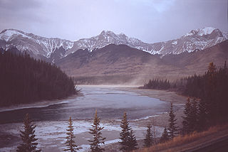
The McLeod River is a river in west-central Alberta, Canada. It forms in the foothills of the Canadian Rockies, and is a major tributary of the Athabasca River.

Embarras River (Alberta) watercourse in Canada

The Embarras River is a short river in west-central Alberta, Canada. The river likely derived its name from the French word for obstruction, because it is often obstructed by driftwood.

Embarras, Alberta human settlement in Alberta, Canada

Embarras is a locality in Yellowhead County, Alberta, Canada. It takes its name from the Embarras River. 'Embarrass' is French for 'barrier', probably in reference to the piles of driftwood that often clog the shallow, winding river.

Lovett River river in Canada

The Lovett River is a short river in the Alberta foothills. The Lovett is an early tributary of the Pembina River, itself a major tributary of the Athabasca River. The Lovett River was formerly known as the Little Pembina River, but to avoid confusion its name was changed. The new name was derived from Lovettville, a defunct coal mining town in the vicinity. The settlement took its name from H. A. Lovett, President of North American Collieries, a mining company in the area.

Nikanassin Formation

The Nikanassin Formation is a stratigraphic unit of Late Jurassic (Portlandian) to Early Cretaceous (Barremian) age. It is present along the western edge of the Western Canada Sedimentary Basin in western Alberta and northeastern British Columbia. Its name was first proposed by D.B. Dowling in 1909 (Coal Fields South of Grand Trunk Pacific Railway, in the foothills of the Rocky Mountain, Alberta Page 140 paragraph 4 " to this it is proposed to give the name Nikanassin, from the Cree word meaning outer range" Also it is noted on the map by D.B. Dowling.(Geological Survey of Canada. Incorrect info follows: It was named by B.R. MacKay in 1929 for the Nikanassin Range of the front-central ranges of the Canadian Rockies. Mackay did not designate a type locality for the formation, although he described outcrops near the hamlet of Brûlé, north of the Yellowhead Highway outside of Jasper National Park.

The Blairmore Group, originally named the Blairmore Formation, is a geologic unit of Early Cretaceous age in the Western Canada Sedimentary Basin that is present in southwestern Alberta and southeastern British Columbia. It is subdivided into a series of formations, most of which contain plant fossils. In some areas it contains significant reservoirs of natural gas.

Luscar Group

The Luscar Group is a geologic unit of Early Cretaceous age in the Western Canada Sedimentary Basin that is present in the foothills of southwestern Alberta. It is subdivided into a series of formations, some of which contain economically significant coal deposits that have been mined near Cadomin and Luscar. Coal mining in those areas began in the early 1900s and continues near Luscar as of 2016.

The Gladstone Formation is a stratigraphic unit of Early Cretaceous (Aptian) age in the Western Canada Sedimentary Basin. It is present in the foothills of southwestern Alberta and is named for outcrops along Gladstone Creek, a tributary of the Castle River south of the Crowsnest Pass.

Saunders Creek, Alberta

Saunders Creek is a ghost town in west-central Alberta, Canada. Built as a coal mining community, the town existed from 1913 to 1954. It is located in the foothills of the Canadian Rockies near the David Thompson Highway, about 55 km west of the town of Rocky Mountain House. It was named for Saunders Creek, a small stream that runs immediately west of the townsite. The North Saskatchewan River flows nearby to the south.

References

  1. 1 2 3 Kyba, Daniel; Ross, Jane (2001). Exploring the historic Coal Branch. Calgary, Alberta: Rocky Mountain Books. ISBN   0-921102-83-6.
  2. 1 2 Ross, Toni (1999). Oh! The Coal Branch . Calgary, Alberta: D.W. Friesen and Sons Ltd. ISBN   0-919212-51-4.
  3. Dutton, J.A. (April 1954). "Alberta coal output declines". Western Miner. 27 (4): 42, 44–46.
  4. "Teck Cardinal River Operations". Archived from the original on 2014-02-02. Retrieved 2014-01-24.Cite uses deprecated parameter |deadurl= (help)

Coordinates: 53°11′N117°01′W / 53.183°N 117.017°W / 53.183; -117.017