Related Research Articles

The London Borough of Redbridge is a London borough in East London, England. It is home to Redbridge Institute of Adult Education and Redbridge Football Club.
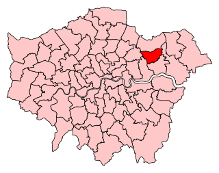
Ilford South is a constituency created in 1945 represented in the House of Commons of the UK Parliament since 2019 by Sam Tarry of the Labour Party.

Little Ilford is a district of London, England in the London Borough of Newham and the name of a ward in that borough.
Ilford Football Club is a football club based in Ilford, East London, England. Affiliated to the Essex County Football Association, they are currently members of the Essex Senior League and play at the Cricklefield Stadium.
Ilford was a civil parish and local government district in south west Essex, England from 1888 to 1965, covering the town Ilford. The district saw a considerable rise in population throughout its life, caused by the expansion of the built-up area of London, and became one of the most populous districts of its type in England. The district now corresponds to the greater part of the London Borough of Redbridge in Greater London.
Wanstead Flats is the southernmost portion of Epping Forest covering Leytonstone and Wanstead, London. The flats and by extension the forest ends at Forest Gate directly to the south. It now falls wholly within the boundaries of London Borough of Redbridge and London Borough of Waltham Forest, though until 1994 two parts of it were in the London Borough of Newham - one of these was the section between Aldersbrook Road and Capel Road east of the junction between Aldersbrook Road and St Margaret's Road, whilst the other was the strip running along Capel Road between its junctions with Centre Road and Ridley Road. As part of Epping Forest, the flats is managed by the City of London Corporation.
The A118 is a road in east London, England which links Bow Interchange with Gallows Corner in Romford via Stratford and Ilford. The section from Bow Interchange to Gallows Corner formed the original route of the A12 until the designation was transferred to the Eastern Avenue soon after the latter opened in 1925. Parts of the route have an even older pedigree, forming the Camulodunum (Colchester) to Londinium (London) extension of the Pye Road.

Wanstead Park is a municipal park covering an area of about 140 acres, in Wanstead, in the London Borough of Redbridge. It is also a district of the London Borough of Redbridge, which was in Essex until 1965. The park is bordered to the north by the A12 road, to the east by the River Roding and A406 North Circular Road, to the south by the Aldersbrook Estate, the site of the former Wanstead Sewage Works and the City of London Cemetery and Crematorium and to the west by Wanstead Golf Course. It is administered as part of Epping Forest by the City of London Corporation, having been purchased by the Corporation in 1880 from Henry Wellesley, 1st Earl Cowley. Today's park once formed part of the deer park of the former manor house of ancient Wanstead Manor, which included much of the urbanised area now known as Wanstead. The present park retains some of the layout of its former existence as Wanstead House's grounds, though the park's western boundary lies some 330 yards east of the house's site. In 1992 a Management Plan was initiated to try to re-establish something of the formality of the grounds of a "Great House".

Aldersbrook, is an Edwardian housing estate in Wanstead, East London. It is named after the medieval Manor of Aldersbrook the manor itself was named after the Alders Brook, a minor river which marks part of the boundary between the London Boroughs of Newham and Redbridge. The area and the estate now wholly fall within the London Borough of Redbridge, though historically Aldersbrook Manor has always fallen inside the parish of Little Ilford, which is in turn part of what is now the London Borough of Newham.

The 1944 Ilford rail crash occurred on 16 January 1944 when, in darkness and dense fog, an express passenger train passed a signal at danger and collided with another passenger train that was stopped at Ilford railway station in Essex, England.

Smart Lethieullier was an English antiquary.

Burnt Oak Brook is a one-mile-long stream between Mill Hill and Burnt Oak in the London Borough of Barnet. It is a tributary of the Silk Stream, which is a tributary of the River Brent, which is a tributary of the River Thames.

St Alban's Church, Ilford, is a Church of England church and parish in Ilford, part of the London Borough of Redbridge. It began as a temporary building, replaced by a permanent Neo-Gothic redbrick one on Albert Road built between 1900 and 1906. Both of these were chapels of ease to St Clement's Church, Ilford until the formation of a separate parish of St Alban's in 1958 It is now a Forward in Faith parish
St Mary's Church, Ilford or St Mary's Church, Great Ilford is a Church of England parish church in Ilford in the London Borough of Redbridge. A new ecclesiastical parish for Great Ilford was split off from that of Barking in 1830 and its church building completed the following year. Its first vicar was appointed in 1837 - its advowson was initially vested in All Souls College, Oxford. A tower was added in 1866 and a chancel, lady chapel and vestries in 1920. St Clement's Church was completed as a chapel of ease for it in 1896, before becoming the parish's main church in 1902.

St Cedd's Church, Barkingside is a Church of England parish church in the Barkingside district of Ilford in the London Borough of Redbridge, dedicated to Cedd, bishop of Essex, in which Ilford historically fell. In 1938 a temporary church was built and a conventional district set up using parts of the parishes of Holy Trinity, Barkingside and Holy Trinity, South Woodford.
Aldersbrook Manor or the Manor of Aldersbrook was a feudal manor in the parish of Little Ilford, now part of the London Borough of Redbridge. It was named after the Alders Brook which flowed through it and the manor's lands mostly now mostly fall within the City of London Cemetery and Crematorium, with its manor house about halfway between the Cemetery's catacombs and its eastern boundary fence. It was known as Aldersbrook House and also had an associated farmhouse about 0.3 km to its west.

St Gabriel's Church is a Church of England parish church in the Aldersbrook estate area of Wanstead in the London Borough of Redbridge, dedicated to the archangel Gabriel. It began in 1903 as an iron building before a permanent brick church by Charles Spooner in the Perpendicular iteration of the neo-Gothic style was completed in 1914, the same year as St Gabriel's was granted its own parish, taking areas from the parishes of St Mary the Virgin, Wanstead, and St Mary's Church, Little Ilford.
Aldersbrook Baptist Church is a Baptist church in the Aldersbrook area of Wanstead in the London Borough of Redbridge. It was formally constituted in 1906, though it had its origins in an 1898 non-denominational mission and a hall on Dover Road in 1902. Its present church building was built beside the hall in 1909, with membership peaking at around 100 people during the 1930s. It was completely rebuilt following bombing in World War II.

Bourne Alder Carr is a 13.4-hectare (33-acre) biological Site of Special Scientific Interest east of Sevenoaks in Kent.
References
- ↑ Wanstead Wildlife: Discovering the Alders Brook
- ↑ Mills, A.D. (2010). A Dictionary of London Place-Names. Oxford University Press. p. 5. ISBN 9780199566785.