Alexander Clark Park, Loganholme

Last updated

Alexander Clark Park, Loganholme
Alex Clark Park
Alexander Clark Park, Loganholme, Queensland.jpg
2016
Australia Queensland location map.svg
Red pog.svg
Location in Queensland
Alexander Clark Park, Loganholme, Queensland - locality map.svg
Red pog.svg
Location in Loganholme
TypeRecreation, Native Flora
Location Loganholme, Queensland, Australia
Coordinates 27°42′05″S153°11′24″E / 27.701265°S 153.190046°E / -27.701265; 153.190046 Coordinates: 27°42′05″S153°11′24″E / 27.701265°S 153.190046°E / -27.701265; 153.190046
Area23 hectares (57 acres)
Created1975 (1975)
Administered byLogan City Council
Website Alexander Clark Park - Logan City Council

Alexander Clark Park, Loganholme is a recreation park featuring native flora in Logan City, Queensland, Australia. Facilities include walking and cycling paths, wheelchair access, dog off-leash areas, picnic tables and barbecues, children playgrounds, fitness equipment, and riverside pontoons. [1] The Loganholme park occupies an inner bend of the Logan River upstream from the Pacific Motorway crossing and Logan River Parklands. Diverse and endangered tree species have been protected within the park.

Contents

History

Playground Playground at Alexander Clark Park in Loganholme, Queensland.jpg
Playground

Situated in what is now the suburb of Loganholme, the park once formed part of 1,280 acres (518 ha) applied for by Thomas Oldham around 1862, under the government regulations of 1861 to encourage cotton growing. [2] After subdivision, and establishment of the Loganholme Plantation to grow sugar cane by the surveyor William Fryar, the land was eventually purchased by the pastoralist James Tyson in 1876. [3]

A housing estate development in the 1970s, Marana Gardens, included an area for the park which was named Alexander Clark Memorial Park in 1976 after the pioneer and former councillor for the Albert Shire; the site having once formed part of his family's property. [4]

In 1981, the North Albert Bowhunters Club moved to the site, establishing a competition range and camping area; by 1983 however, there were difficulties with the council planning a public recreational facility. [5] During the 1980s and 1990s an Australian Football playing field was located in the park, home to local football club the Cobra's .

The park has a bushcare group which was granted funds in 2003 under the National Landcare Programme to remove weeds along the river aiming to prevent erosion, plant native trees and help in the recovery of the endangered Angle-stemmed myrtle tree species. [6]

Native flora

Tree species which are native to the subtropical and warm temperate habitat of the Moreton Bay region can be seen in the park. Along with 200 year old blue gum trees (also known as forest red gums, Eucalyptus tereticornis ), [1] notable trees include:

Map this section's coordinates using: OpenStreetMap  
Download coordinates as: KML
Common name [a] Labelled specimen [b]
Aleurites moluccanus candle nut 27°42′05″S153°11′30″E / 27.70133°S 153.19158°E / -27.70133; 153.19158 (Aleurites moluccanus (candle nut))
Alphitonia excelsa soap tree 27°42′06″S153°11′31″E / 27.70163°S 153.19207°E / -27.70163; 153.19207 (Alphitonia excelsa (soap tree))
Alstonia scholaris milky pine 27°42′05″S153°11′30″E / 27.70141°S 153.19156°E / -27.70141; 153.19156 (Alstonia scholaris (milky pine))
Castanospermum australe blackbean 27°42′06″S153°11′31″E / 27.70159°S 153.19207°E / -27.70159; 153.19207 (Castanospermum australe (blackbean))
Eucalyptus tereticornis forest red gum 27°42′06″S153°11′32″E / 27.70153°S 153.19209°E / -27.70153; 153.19209 (Eucalyptus tereticornis (forest red gum))
Ficus macrophylla Moreton Bay fig 27°42′06″S153°11′30″E / 27.70178°S 153.19163°E / -27.70178; 153.19163 (Ficus macrophylla (Moreton Bay fig))
Flindersia schottiana bumpy ash 27°42′04″S153°11′30″E / 27.70124°S 153.19173°E / -27.70124; 153.19173 (Flindersia schottiana (bumpy ash))
Jagera pseudorhus foam bark tree 27°42′06″S153°11′31″E / 27.70157°S 153.19207°E / -27.70157; 153.19207 (Jagera pseudorhus (foam bark tree))
Melaleuca bracteata black tea-tree 27°42′04″S153°11′30″E / 27.7011°S 153.19158°E / -27.7011; 153.19158 (Melaleuca bracteata (black tea-tree))
Melaleuca viminalis weeping bottlebrush 27°42′05″S153°11′34″E / 27.70137°S 153.19266°E / -27.70137; 153.19266 (Melaleuca viminalis (weeping bottlebrush))
Melia azedarach white cedar 27°42′06″S153°11′33″E / 27.70162°S 153.19263°E / -27.70162; 153.19263 (Melia azedarach (white cedar))
Nauclea orientalis Leichhardt tree 27°42′04″S153°11′30″E / 27.70123°S 153.19164°E / -27.70123; 153.19164 (Nauclea orientalis (Leichhardt tree))
a common names sourced from park labels
b trees with botanical signs in the park

Angle-stemmed myrtle

Exercise equipment and covered tables Exercise equipment and covered tables at Alexander Clark Park in Loganholme, Queensland.jpg
Exercise equipment and covered tables

The park is one nine localities known for original populations of the endangered Gossia gonoclada (synonym Austromyrtus gonoclada) of the myrtle family, found only in the Moreton Bay region. Two naturally occurring G. gonoclada trees are recorded in the park, with a further 31 having been planted as part of a recovery plan for the species. [7]

Related Research Articles

Brisbane Capital city of Queensland, Australia

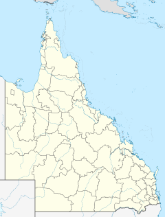
Brisbane, sited on the Meanjin land of the Turrbal Country, is the capital and most populous city of the Australian state of Queensland, and the third-most populous city in Australia. Brisbane's metropolitan area has a population of around 2.6 million, and it lies at the centre of the South East Queensland metropolitan region, which encompasses a population of around 3.8 million. The Brisbane central business district is situated within a peninsula of the Brisbane River about 15 km (9 mi) from its mouth at Moreton Bay, a bay of the Coral Sea. The metropolitan area extends in all directions along the hilly floodplain of the Brisbane River Valley between Moreton Bay and the Taylor and D'Aguilar mountain ranges. It sprawls across several of Australia's most populous local government areas (LGAs) — most centrally the City of Brisbane, the most populous LGA in the nation.

Moreton Bay inlet in southern Queensland, Australia

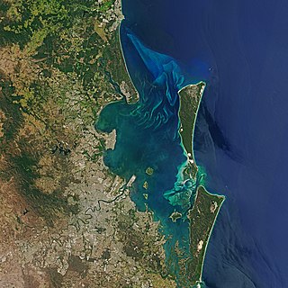
Moreton Bay is a bay located on the eastern coast of Australia 14 kilometres (8.7 mi) from central Brisbane, Queensland. It is one of Queensland's most important coastal resources. The waters of Moreton Bay are a popular destination for recreational anglers and are used by commercial operators who provide seafood to market.

Patrick Logan Commandant of penal colony

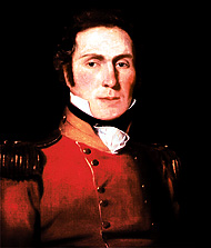
Captain Patrick Logan was the commandant of the Moreton Bay Penal Settlement from 1826 until his death in 1830 at the hands of Aboriginal Australians who objected to him entering their lands. As he had been hated by convicts, there were rumours that escaped convicts living in the bush had attacked him, but there is no evidence of this.

Logan River

The Logan River is a perennial river located in the Scenic Rim, Logan and Gold Coast local government areas of the South East region of Queensland, Australia. The 184-kilometre (114 mi)-long river is one of the dominant waterways in South East Queensland that drains the southern ranges of the Scenic Rim and empties into Moreton Bay after navigating the City of Logan, a major suburban centre located south of Brisbane. The catchment is dominated by urban and agricultural land use. Near the river mouth are mangrove forests and a number of aquaculture farms.

Logan City Local government area in Queensland, Australia

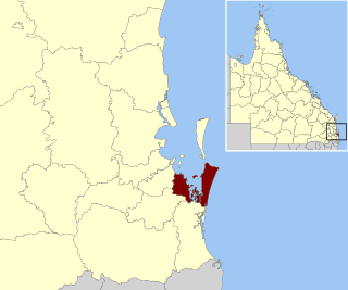
Logan City is a local government area situated within the south of the Brisbane metropolitan area in South East Queensland, Australia. Situated between the City of Brisbane to the north and the City of Gold Coast to the south, the City also borders the Scenic Rim Region, the City of Ipswich, and Redland City LGAs. Logan City is divided into 70 suburbs and 12 divisions; a councillor is elected to each of the latter. The area had a population of 326,615 in June 2018.

Redland City Local government area in Queensland, Australia

Redland City, better known as the Redlands and formerly known as Redland Shire, is a local government area and a part of the Brisbane metropolitan area in South East Queensland. With a population of 156,863 in June 2018, the City is spread along the southern coast of Moreton Bay, covering 537.2 square kilometres (207.4 sq mi). Its mainland borders the City of Brisbane to the west and north-west, and Logan City to the south-west and south, while its islands are situated north of the City of Gold Coast.

Logan Hyperdome Shopping mall in Queensland, Australia

Logan Hyperdome Shopping Centre in Shailer Park, Queensland, is the largest shopping centre in Logan City and one of the largest single storey shopping centres in Australia.

Loganholme, Queensland Suburb of Logan City, Queensland, Australia

Loganholme is a suburb in the City of Logan, Queensland, Australia. In the 2016 census, Loganholme had a population of 6,303 people.

Shailer Park, Queensland Suburb of City of Logan, Queensland, Australia

Shailer Park is a suburb in the City of Logan, Queensland, Australia. In the 2016 census, Shailer Park had a population of 11,759 people.

Tanah Merah, Queensland Suburb of Logan City, Queensland, Australia

Tanah Merah is a residential suburb in the City of Logan, Queensland, Australia. In the 2016 census, Tanah Merah had a population of 4,752 people. It was originally named by the Queensland Place Names Board in 1971.

The greater Brisbane area of Queensland Australia, has many species of indigenous flora. This article links the flora to its geography with:

Eagleby, Queensland Suburb of Logan City, Queensland, Australia

Eagleby is a suburb in the City of Logan, Queensland, Australia. In the 2016 census, Eagleby had a population of 13,326 people.

Lenwebbia is a genus of 2 species of shrubs or small trees in the myrtle family Myrtaceae. The genus is named to honour the Australian plant ecologist Dr. Leonard Webb. The genus occurs in mesic forests along or near the east coast of Australia, from northern New South Wales to northeastern Queensland.

Burpengary Creek is a tidal creek in Moreton Bay Region, Queensland, Australia. It has a total catchment area of 7,960 hectares. It is about 40 kilometres north of Brisbane,

Logan Village, Queensland Suburb of Logan City, Queensland, Australia

Logan Village is a semi-rural town and locality in the City of Logan, Queensland, Australia. In the 2016 census, the locality of Logan Village had a population of 4,417 people. Logan Village was once known as the head of the navigable Logan River. Its importance as a town grew again when the railway arrived.

Alberton, Queensland Suburb of Gold Coast, Queensland, Australia

Alberton is a rural locality in the City of Gold Coast, Queensland, Australia. In the 2016 census, Alberton had a population of 590 people.

Cotton Tree, Queensland Suburb of Maroochydore, Queensland, Australia

Cotton Tree is a coastal neighbourhood within the suburb of Maroochydore in the Sunshine Coast Region, Queensland, Australia.

Jacobs Well, Queensland Suburb of Gold Coast, Queensland, Australia

Jacobs Well is a coastal suburb in the City of Gold Coast, Queensland, Australia. In the 2016 census, Jacobs Well had a population of 1,839 people.

Sherwood Arboretum

Sherwood Arboretum is a heritage-listed arboretum at 39A Turner Street, Sherwood, Queensland, Australia. A 1946 addition to the site is also known as the John Herbert Memorial Vista. It was added to the Queensland Heritage Register on 3 May 2007.

Gossia gonoclada, known as the square-stemmed or angle-stemmed myrtle for the distinctive four raised corners on the angled branchlets, is a rainforest tree of the family Myrtaceae, native to south-east Queensland, Australia. It is an endangered species.

References

  1. 1 2 "Alexander Clark Park". Logan City Council - Parks Directory. Retrieved 12 July 2016.
  2. Buchanan, Robyn, Logan: Rich in History - The Short Reign of King Cotton (PDF), Logan City Council, p. 27, retrieved 12 July 2016
  3. Suburb History - Loganholme (PDF), Logan City Council, retrieved 12 July 2016
  4. "Pioneer Honoured (news cutting)" (c. January 1976). Local Studies collection, File: Loganholme. Logan Central Library: Logan City Council. Retrieved 15 July 2016.
  5. "Bowhunters are now on the outer". Albert and Logan News . 13 May 1983. p. 44.
  6. "Control of Balloon Vine in Alexander Clark Park Loganholme Queensland". Australian Government funded NRM project details. Department of Agriculture and the Department of the Environment. Archived from the original on 24 February 2014. Retrieved 5 November 2016.
  7. Austromyrtus gonoclada Recovery Team; McNeill, Fiona (2001). Recovery plan for the angle-stemmed myrtle Austromyrtus gonoclada 2001-2005 (PDF) (Report). Queensland Parks and Wildlife Service, Brisbane. Retrieved 12 July 2016.

Further reading