Alexander III of Macedon, commonly known as Alexander the Great, was a king of the ancient Greek kingdom of Macedon. He succeeded his father Philip II to the throne in 336 BC at the age of 20, and spent most of his ruling years conducting a lengthy military campaign throughout Western Asia and Egypt. By the age of 30, he had created one of the largest empires in history, stretching from Greece to northwestern India. He was undefeated in battle and is widely considered to be one of history's greatest and most successful military commanders.
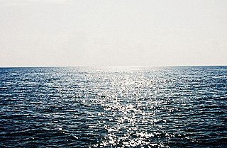
The Arabian Sea is a region of sea in the northern Indian Ocean, bounded on the west by the Arabian Peninsula, Gulf of Aden and Guardafui Channel, on the northwest by Gulf of Oman and Iran, on the north by Pakistan, on the east by India, and on the southeast by the Laccadive Sea and the Maldives, on the southwest by Somalia. Its total area is 3,862,000 km2 (1,491,000 sq mi) and its maximum depth is 4,652 meters (15,262 ft). The Gulf of Aden in the west connects the Arabian Sea to the Red Sea through the strait of Bab-el-Mandeb, and the Gulf of Oman is in the northwest, connecting it to the Persian Gulf.
Agatharchides or Agatharchus of Cnidus was a Greek historian and geographer.
Nearchus or Nearchos was one of the Greek officers, a navarch, in the army of Alexander the Great. He is known for his celebrated expeditionary voyage starting from the Indus River, through the Persian Gulf and ending at the mouth of the Tigris River following the Indian campaign of Alexander the Great, in 326–324 BC.

The Periplus of the Erythraean Sea, also known by its Latin name as the Periplus Maris Erythraei, is a Greco-Roman periplus written in Koine Greek that describes navigation and trading opportunities from Roman Egyptian ports like Berenice Troglodytica along the coast of the Red Sea, and others along Horn of Africa, the Persian Gulf, Arabian Sea and the Indian Ocean, including the modern-day Sindh region of Pakistan and southwestern regions of India.
Hanno the Navigator was a Carthaginian explorer of the fifth century BC, best known for his naval exploration of the western coast of Africa. The only source of his voyage is a periplus translated into Greek. He has sometimes been identified as a king.

A periplus, or periplous, is a manuscript document that lists the ports and coastal landmarks, in order and with approximate intervening distances, that the captain of a vessel could expect to find along a shore. In that sense, the periplus was a type of log and served the same purpose as the later Roman itinerarium of road stops. However, the Greek navigators added various notes, which, if they were professional geographers, as many were, became part of their own additions to Greek geography.

The Battle of the Granicus in May 334 BC was the first of three major battles fought between Alexander the Great of Macedon and the Persian Achaemenid Empire. The battle took place on the road from Abydus to Dascylium, at the crossing of the Granicus in the Troad region, which is now called the Biga River in Turkey. In the battle Alexander defeated the field army of the Persian satraps of Asia Minor, which defended the river crossing. After this battle, the Persians were forced on the defensive in the cities that remained under their control in the region.
Rhapta was an emporion said to be on the coast of Southeast Africa, first described in the 1st century CE. Its location has not been firmly identified, although there are a number of plausible candidate sites. The ancient Periplus of the Erythraean Sea described Rhapta as "the last emporion of Azania", two days' travel south of the Menouthias islands. The Periplus also states that the city and port were ruled by South Arabian vassals of the Himyarite kingdom, particularly a certain “ Mapharitic chieftain.”

Ordu or Altınordu is a port city on the Black Sea coast of Turkey, historically also known as Cotyora or Kotyora, and the capital of Ordu Province with a population of 229,214 in the city center.
Pasni, is a city and a fishing port in Gwadar District, Balochistan, Pakistan. It is located on the Makran coast on Arabian Sea about 450 km (280 mi) from Karachi. Administratively, Pasni is the headquarters of Pasni Tehsil, the sub-division of Gwadar District. Astola Island lies 40 km (25 mi) ESE of Pasni, in the Arabian Sea. The city of Pasni is itself administratively subdivided into two Union Councils.

Ormara, is a town in Gwadar District in the Balochistan province of Pakistan. It is a port on the Makran coastal region. It is located 360 kilometres (220 mi) west of Karachi and 230 kilometres (140 mi) east of Gwadar on the Arabian Sea. This port is also mentioned in Periplus of the Erythraean Sea as Oraea.
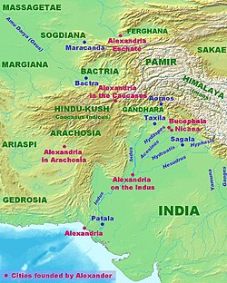
Bela is an important city of Lasbela District in the Balochistan province of Pakistan. It is an ancient city in a historic track surrounded by hills above the Arabian Sea, nearly 180 km (110 mi) northwest of Karachi and 500 km (310 mi) south of Quetta. During the autumn of 325 BC, the settlement was part of the Asian campaign of Alexander the Great under the name Rhambacia. After Alexander conquered the town, he commended the place and thought that if he built a city there it would become great and prosperous and he left Hephaestion behind to built it. In 711 AD, it was part of Muhammad bin Qasim's campaign under the name Armabil.

Gangaridai is a term used by the ancient Greco-Roman writers to describe a people or a geographical region of the ancient Indian subcontinent. Some of these writers state that Alexander the Great withdrew from the Indian subcontinent because of the strong war elephant force of the Gangaridai.

Ancient Aethiopia, first appears as a geographical term in classical documents in reference to the upper Nile region of Sudan, as well as certain areas south of the Sahara. Its earliest mention is in the works of Homer: twice in the Iliad, and three times in the Odyssey. The Greek historian Herodotus "specifically" uses the appellation to refer to such parts of sub-Saharan Africa as were then known within the inhabitable world.

Boukephala and Nikaia were two cities founded by Alexander the Great on either side of the Hydaspes, during his invasion of the Indian subcontinent. Two of many cities founded by the Macedonian king, the cities were founded shortly after Alexander's victory over the Indian king Porus at the Battle of the Hydaspes in spring 326 BC.

The Erythraean Sea was a former maritime designation that always included the Gulf of Aden and at times other seas between Arabia Felix and the Horn of Africa. Originally an ancient Greek geographical designation, it was used throughout Europe until the 18–19th centuries. At times the name frequently extended beyond the Gulf of Aden—as in the famous 1st-century Periplus of the Erythraean Sea—to include the present-day Red Sea, Arabian Sea, Persian Gulf, and Indian Ocean as a single maritime area.

Minnagara was a city of the Indo-Scythian kingdom, located on the Indus river in modern Pakistan, north of the coastal city of Barbaricum, or along the Narmada river, upstream of Barygaza. There were two cities named Minnagara, one on Indus River delta near Karachi and the other at Narmada River delta near modern Bharuch.
Oraea was the name of a sea port near the modern-day city of Ormara, Balochistan province of Pakistan, important in the Hellenistic era in Indian Ocean trade. It is mentioned briefly in the Periplus of the Erythraean Sea:

The Indian campaign of Alexander the Great began in 327 BC and lasted until 325 BC. After conquering the Achaemenid Persian Empire, the Macedonian army undertook an expedition into the Indian subcontinent. Within two years, Alexander expanded the Macedonian Empire to include present-day Punjab and Sindh in what is Modern-day Pakistan, surpassing the earlier frontiers that had been established by the Persian conquest of the Indus Valley.