
The Moselle is a river that rises in the Vosges mountains and flows through north-eastern France, Luxembourg, and western Germany. It is a left bank tributary of the Rhine, which it joins at Koblenz. A small part of Belgium is in its basin as it includes the Sauer and the Our.

Ahr is a river in Germany, a left tributary of the Rhine. Its source is at an elevation of approximately 470 metres (1,540 ft) above sea level in Blankenheim in the Eifel, in the cellar of a timber-frame house near the castle of Blankenheim. After 18 kilometres (11 mi) it crosses from North Rhine-Westphalia into Rhineland-Palatinate.

The Nahe is a river in Rhineland-Palatinate and Saarland, Germany, a left tributary to the Rhine. It has also given name to the wine region Nahe situated around it.
The Kyll, noted by the Roman poet Ausonius as Celbis, is a 128-kilometre-long (80 mi) river in western Germany, left tributary of the Moselle. It rises in the Eifel mountains, near the border with Belgium and flows generally south through the towns Stadtkyll, Gerolstein, Kyllburg and east of Bitburg. It flows into the Moselle in Ehrang, a suburb of Trier.
The Salm is a 63-kilometre-long (39 mi) river in western Germany (Rhineland-Palatinate), a left-bank tributary to the river Moselle. It rises in the Eifel, near the village of Salm, south of Gerolstein. The Salm flows generally south, through Großlittgen, Dreis, and Salmtal. It passes west of Wittlich. It empties into the Moselle in Klüsserath.

The Swist is a stream, 43.6 kilometres (27.1 mi) long, in the German Rhineland. It rises on the northern edge of the Eifel at 330 metres above sea level and empties rom the right and southeast into the Rhine tributary, the Erft, between Weilerswist and Bliesheim. Occasionally the Swist is also called the Swistbach, and locals often just call it der Bach.

Bausendorf is an Ortsgemeinde – a municipality belonging to a Verbandsgemeinde, a kind of collective municipality – in the Bernkastel-Wittlich district in Rhineland-Palatinate, Germany.

Bengel is an Ortsgemeinde – a municipality belonging to a Verbandsgemeinde, a kind of collective municipality – in the Bernkastel-Wittlich district in Rhineland-Palatinate, Germany.

Kinheim is an Ortsgemeinde – a municipality belonging to a Verbandsgemeinde, a kind of collective municipality – in the Bernkastel-Wittlich district in Rhineland-Palatinate, Germany.

The Queich is a tributary of the Rhine, which rises in the southern part of the Palatinate Forest, and flows through the Upper Rhine valley to its confluence with the Rhine in Germersheim. It is 52 kilometres (32 mi) long and is one of the four major drainage systems of the Palatinate Forest along with the Speyerbach, Lauter and Schwarzbach. The Queich flows through the towns Hauenstein, Annweiler am Trifels, Siebeldingen, Landau, Offenbach an der Queich and Germersheim.
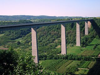
The Moselle Viaduct carries the Bundesautobahn 61 over a meander of the river Moselle, connecting the Hunsrück and Eifel mountain ranges. It was built between 1969 and 1972 between the German villages Winningen and Dieblich, about 10 kilometres (6.2 mi) southwest of Koblenz, where the river Moselle flows into the river Rhine.

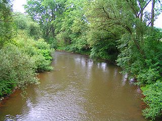
The Lieser is a small river in Rhineland-Palatinate, Germany, a left tributary of the Moselle. It rises in the Eifel, near Boxberg, north of Daun. The Lieser flows south through Daun, Manderscheid and Wittlich. It flows into the Moselle west of the village of Lieser.

The Speyerbach is a left tributary of the Rhine in the Palatinate part of Rhineland-Palatinate. In Speyer, the river split into Gießhübelbach and Woogbach. The Woogbach changes its name to Nonnenbach, then flows into Gießhübelbach shortly before the latter flows into the Rhine.

The Moselle Hills form a ridge, up to 434.1 m above sea level (NHN), on the left bank of the River Moselle between Reil and Schweich in the Rhineland-Palatinate counties of Bernkastel-Wittlich and Trier-Saarburg. There are vineyards on the southern slopes of the wooded hills. They lie on the southern edge of the Eifel region.
The Kondelwald, also known as the Kondel, is a forest, about 2,500 hectares in area and up to 477.5 m above sea level (NHN), that forms part of the Moselle Eifel. It lies within the counties of Bernkastel-Wittlich and Cochem-Zell in the German state of Rhineland-Palatinate. It used to belong to the imperial Carolingian estate of Kröver Reich.

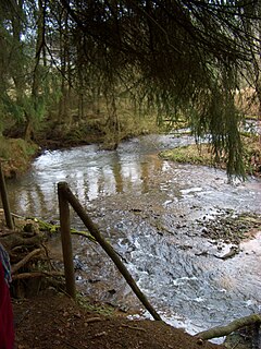
The Riveris is an orographically right-hand, southern tributary of the River Ruwer in the German state of Rhineland-Palatinate. It was impounded in 1953 by the Riveris Dam which inter alia supplies water to the town of Trier. The name Riveris is derived from the Latin and means "little river".
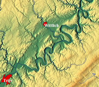
The Wittlich Depression , less commonly, the Wittlich Basin, is the continuation of the Trier Valley in a northeasterly direction. It is not only recognisable in the terrain as an elongated depression, but also from its geological structure as a basin. From a natural region perspective, the Wittlich Depression (252) is one of three major units of the Moselle Valley major unit group Moseltal (25). The Wittlich Depression Cycleway runs through the region.

The Häuschen is a hill, 506.5 m above sea level (NHN), in the Eifel mountains. It rises near Ahrweiler in the county of Ahrweiler in the German state of Rhineland-Palatinate.

The Enz is a 37.9-kilometre-long (23.5 mi), orographically right-hand tributary of the Prüm in the Eifel mountains of Germany.
The Alfbach is a 22.3-kilometre-long (13.9 mi), orographically right-bank tributary of the Prüm in the county of Bitburg-Prüm in the German state of Rhineland-Palatinate.

