
Alfaro is an electoral urban parish or district of Quito, Ecuador. The parish was established as a result of the October 2004 political elections, when the city was divided into 19 electoral urban parishes. [1]
Alfaro is an electoral urban parish or district of Quito, Ecuador. The parish was established as a result of the October 2004 political elections, when the city was divided into 19 electoral urban parishes. [1]

Quito, officially the Metropolitan District of Quito, is a canton in the province of Pichincha, Ecuador.
Puerto Quito is a canton in Pichincha Province, Ecuador. It has only one parish, the urban parish of Puerto Quito, which is also the seat of the canton.
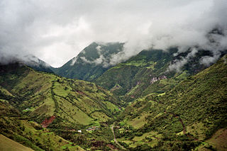
San Miguel de los Bancos, or simply Los Bancos, is a canton in the province of Pichincha, Ecuador. The long name of the town refers to dedication of the area to the archangel Michael. Local tradition attributes the "Los Bancos" part of the name to the use of tree trunks as benches at the junction of the through road from Quito to Esmeraldas with the road into the Rio Blanco valley.
Guayllabamba is a small agricultural town located 29 kilometers northeast of the city of Quito in northern Ecuador. In the 2001 census, the parish had a population of 12,227. The elevation is 2,142 metres (7,028 ft) above sea level.

Rumiñahui or Rumiñawi is a canton of Pichincha Province in Ecuador. Its seat is Sangolquí. The canton lies southeast of Quito Canton and forms a suburb of Quito.
Chaupicruz is an electoral parish or district of Quito, the capital city of Ecuador in northwestern South America. The parish was established as a result of the October 2004 political elections when the city was divided into 19 urban electoral parishes.
El Salvador is an electoral parish or district of Quito, the capital city of Ecuador. The parish was established as a result of the October 2004 political elections when the city was divided into 19 urban electoral parishes.

Guápulo is a district of Quito, Ecuador, also called an electoral parish. The parish was established as a result of the October 2004 political elections when the city was divided into 19 urban electoral parishes. Set behind Hotel Quito, the neighborhood of Guápulo runs down the winding Camino de Orellana, from González Suárez to Calle de los Conquistadores, the main road out of Quito and to the neighboring suburbs. Often considered an artsy, bohemian neighborhood of Quito, Guápulo is home to many local artists and a couple of hippy cafés/bars. Every year on September 7 the guapuleños honor their neighborhood with the Fiestas de Guápulo, a fantastic celebration complete with costumes, parade, food, drink, song, dance, and fireworks.
La Floresta is an electoral parish or district of Quito, the capital city of Ecuador. The parish was established as a result of the October 2006 political elections when the city was divided into 19 urban electoral parishes.
La Libertad is an urban parish in the city of Quito, Ecuador. It is located in the southern part of the city, just south of the city center and on the slopes of the Pichincha volcano.
La Magdalena is an electoral parish or district of Quito, the capital city of Ecuador. The parish was established as a result of the October 2004 political elections when the city was divided into 19 urban electoral parishes.
La Vicentina is an electoral parish or district of Quito, Ecuador. The parish was established as a result of the October 2004 political elections when the city was divided into nineteen urban electoral parishes.
San Blas is an electoral parish Parish or district of Quito. The parish was established as a result of the October 2004 political elections when the city was divided into 19 urban electoral parishes.
Santa Prisca is an electoral parish or district of Quito, the capital city of Ecuador. The parish was established as a result of the October 2004 political elections when the city was divided into 19 urban electoral parishes.
Lloa is a rural parish of Quito Canton, Pichincha Province, Ecuador. The seat of the parish, which is the village of Lloa, lies west of the southern part of the city of Quito and approximately southeast of Guagua Pichincha Volcano, surrounded by some foothills of the Pichincha Volcano.
Calderón is a rural parish of Quito Canton, Pichincha Province, Ecuador. It lies northeast of the city of Quito, on Ecuador Highway 35, a north-to-south-running highway which is the Ecuadorian segment of the Pan-American Highway.

Casitahua is a dormant, eroded volcano in the north of Quito Canton, Pichincha Province, Ecuador. The volcano is in the Western Cordillera of the northern Ecuadorian Andes, between Pululagua Volcano to the north and Pichincha Volcano approximately to the southwest. Casitahua's caldera is open approximately towards the west-northwest.
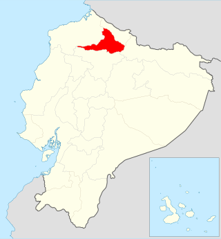
San Miguel de Urcuquí Canton, or Urkuki, is a canton of Ecuador, located in the Imbabura Province. Its seat is the town of Urcuquí. Its population in the 2001 census was 14,381 and was 15,671 in the 2010 census. The area of the canton is 779 square kilometres (301 sq mi).
The National Assembly is the unicameral legislature of Ecuador. It replaced the National Congress in 2009 following reforms under the 2008 Constitution. It is currently dissolved after the country's President Guillermo Lasso invoked a muerte cruzada. Within Ecuador, the National Assembly has the power to pass laws, while appointment of judges to the National Court of Justice is done by a separate Judicial Council.
Pomasqui is a village in Quito Canton, Ecuador. Located 16 kilometres (9.9 mi) north of Quito, and 6 kilometres (3.7 mi) from the equator, it is on the road to Ciudad Mitad del Mundo. The village's main plaza, Plaza Yerovi, features two churches, the Church of El Senor del Arbol, as well as the parish church, which contains some religious paintings which are considered odd. Santa Clara is the patron saint of Pomasqui. Dia de Santa Clara and the fiesta of El Senor del Arbol are both celebrated in July. The economy features a shoe industry, which uses parts of the maguey plant found in the region. The climate is so dry as to have given it the name of Piurita. The southern boundary of the Cara culture, extended to Pomasqui.
0°13′58.7″S78°30′53.9″W / 0.232972°S 78.514972°W
| | This Ecuador location article is a stub. You can help Wikipedia by expanding it. |
