
Quito, officially San Francisco de Quito, is the capital of Ecuador, with an estimated population of 2.8 million in its metropolitan area. It is also the capital of the province of Pichincha. Quito is located in a valley on the eastern slopes of Pichincha, an active stratovolcano in the Andes.

Cuenca, officially Santa Ana de los Ríos de Cuenca, is an Ecuadorian city, head of the canton of the same name and capital of the province of Azuay, as well as its largest and most populated city. It is crossed by the Tomebamba, Tarqui, Yanuncay and Machángara rivers, in the south-central inter-Andean region of Ecuador, in the Paute river basin, at an altitude of 2,538 meters above sea level and with a temperate Andean climate averaging 16.3 °C.

Samborondon is a parish and town in Ecuador’s Guayas province. It is the seat of Samborondón Canton, which consist of 105 localities and two urban parishes and Samborondón Town and one rural parish (Tarifa). La Puntilla's parish is one of the most exclusive residential and entertainment districts in Ecuador. It has many Gated Communities, and several retail developments are located in the suburb. Its close proximity to the country's largest city, Guayaquil, allows many of its residents to work there. Most of the upper-class families in Guayaquil live at La Puntilla's Parish in Samborondón.

Mejía is a canton in the province of Pichincha in northern Ecuador. It is named after Ecuadorian political figure José Mejía Lequerica. The canton includes a volcano in the Central Cordillera of the Ecuadorian Andes called Rumiñahui. The seat of the canton is called Machachi.
Pedro Moncayo is a canton in the north of the Pichincha Province, Ecuador. The seat of the canton is the city of Tabacundo. The canton is named after politician Pedro Moncayo. The canton is separated by the Mojanda volcano from the canton of Otavalo in the province of Imbabura in the north. It borders the same-province cantons of Cayambe and Quito.
Puerto Quito is a canton in Pichincha Province, Ecuador. It has only one parish, the urban parish of Puerto Quito, which is also the seat of the canton.
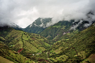
San Miguel de los Bancos, or simply Los Bancos, is a canton in the province of Pichincha, Ecuador. The long name of the town refers to dedication of the area to the archangel Michael. Local tradition attributes the "Los Bancos" part of the name to the use of tree trunks as benches at the junction of the through road from Quito to Esmeraldas with the road into the Rio Blanco valley.
Guayllabamba is a small agricultural town located 29 kilometers northeast of the city of Quito in northern Ecuador. In the 2001 census, the parish had a population of 12,227. The elevation is 2,142 metres (7,028 ft) above sea level.

Mexicali Municipality is a municipality in the Mexican state of Baja California. Its municipal seat is located in the city of Mexicali. As of 2020, the municipality had a total population of 1,049,792. The municipality has an area of 13,700 km2 (5,300 sq mi). This includes many smaller outlying communities as well as the city of Mexicali. Also, the islands of Baja California located in the Gulf of California are part of the municipality, among them the mudflat islands at the mouth of the Colorado River, Isla Ángel de la Guarda and the islands of the San Lorenzo Marine Archipelago National Park. Mexicali is the northernmost municipality of Latin America.

Tijuana Municipality is a municipality in the Mexican state of Baja California. Its municipal seat is located in the city of Tijuana. According to the 2020 census, the municipality had a population of 1,922,523. Montserrat Caballero of the MORENA is the current mayor. The municipality comprises the largest part of the Tijuana metropolitan area.
Cumbayá is a rural parish of the Metropolitan District of Quito in the Pichincha Province, Ecuador. It is located east of Quito, in the Tumbaco Valley northwest of the Ilaló volcano, in the San Pedro River valley, a tributary of the Guayllabamba River.

Rumiñahui or Rumiñawi is a canton of Pichincha Province in Ecuador. Its seat is Sangolquí. The canton lies southeast of Quito Canton and forms a suburb of Quito.
Drinking water supply and sanitation in Ecuador is characterized by a number of achievements and challenges. One key achievement is a significant increase in both access to an at least basic water source and at least basic sanitation. Significant increases in coverage in urban areas were achieved both by the public utility EMAAP-Q, serving the capital Quito, and the private concessionaire Interagua in the country's largest city Guayaquil. However, municipalities rely overwhelmingly upon central government investment, rather than recouping the costs at a local level. Another problem is intermittent water supply, which affects half of the urban areas. Also, only 8% of all collected wastewater is being treated. The level of non-revenue water is estimated at 65%, one of the highest in Latin America. Addressing these challenges is complicated by the atomization of the sector: A multitude of stakeholders – the Ministry of Housing, the Emergency Social Investment Fund, the Solidarity Fund, the State Bank, NGOs, municipalities and others – intervene in the sector. Despite the existence of an Interinstitutional Committee for Water and Sanitation there remains room to improve coordination.
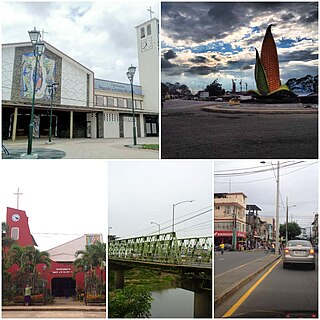
Ventanas it is an Ecuadorian city; head of the Ventanas Canton, in the Los Ríos Province, as well as the fourth most populated city in the Province of Los Ríos. It is located in the center of the coastal region of Ecuador, on an extensive plain, crossed by the Zapotal River, at an altitude of 24 meters above sea level and with a rainy tropical climate of 26 °C on average. It is called "The Corn Capital of Ecuador" for its important production of corn. At the 2022 census it had a population of 41,531, making it the thirty-eighth most populous city in the country. It is part of the metropolitan area of Babahoyo, since its economic, social and commercial activity is strongly linked to Babahoyo, being a "dormitory city" for thousands of workers who travel to that city by land daily. The conglomerate is home to more than 250,000 inhabitants.

According to the Political Constitution of Costa Rica of 1949, in article 168, the territorial division of Costa Rica is organized by law into three types of subnational entity:

Cajabamba is a location in the Chimborazo Province, Ecuador. It is the seat of the Colta Canton.
Alausí Canton is a canton in the Chimborazo Province in Ecuador. Its seat is Alausí. The canton is being promoted as a tourist region, and was named a Pueblo Mágico by the Ecuadorian Ministry of Tourism (MINTUR) in 2019.

Quinindé Canton is a canton of Ecuador, located in the Esmeraldas Province. Its capital is the town of Quinindé. Its population at the 2001 census was 88,337. It is located in the Costa Region. Its cantonal head is the city of Rosa Zárate, a place where a large part of its total population is grouped.

Ventanas Canton is a canton of Ecuador, located in the Los Ríos Province. Its capital is the town of Ventanas. Its population at the 2001 census was 71,145.


