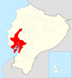
Guayas is a coastal province in Ecuador. It is bordered to the west by Manabí, Santa Elena, and the Pacific Ocean ; to the east by Los Ríos, Bolívar, Chimborazo, Cañar, and Azuay; to the north by Los Ríos and Bolívar; and to the south by El Oro and the Pacific Ocean.

El Oro is the southernmost of Ecuador's coastal provinces. It was named for its historically important gold production. Today it is one of the world's major exporters of bananas. The capital is Machala.

Los Ríos is a province in Ecuador. The capital is Babahoyo. The province was founded on October 6, 1860. Under legislative decree. Babahoyo was made its capital on September 30, 1948.
Naranjal is a canton in the province of Guayas in western continental Ecuador. The canton was named after its seat, Naranjal.

Balsas is a canton in El Oro Province, Ecuador. Its seat is Balsas.
Paltas is located to the south of Loja city and is one of the oldest cantons of province of the same name. It was named after the Paltas, community who used to live over the new city now called Catacocha in Ecuador.
Piñas is a canton in the El Oro Province, Ecuador. Its seat is Piñas. It is also known as the "Orchid of The Andes" because of the many orchids grown nearby. The town was named Piñas by Juan de Loayza, in honor of his homeland Piñas in Spain. It is located 1,126 metres above sea-level.

Celica is a canton in Loja Province, Ecuador. Its seat is Celica. The canton is located in the west of the province and is bordered by the cantons of Puyango and Paltas in the north, Sozoranga in the east, Macará in the south, and Pindal and Zapotillo in the west. It covers 517.8 km² at an altitude of 2500 m.

Daule, also known as Villa Daule, is a canton located in the Guayas province in Ecuador. Created in 1820, it is one of the most important parts of Guayas thanks to its rice production and other products such as corn and eggs.

The Province of Santa Elena is a province of Ecuador in the coastal region. Created in 2007 from territory that belonged to the Guayas Province, it is one of the two newest provinces of Ecuador, along with Santo Domingo de Los Tsáchilas. Its capital city is Santa Elena, from which the province derives its name.
The Sandy River is a river of Minnesota. It is a tributary of the Mississippi River.

Pucará Canton is a canton of Ecuador, located in the Azuay Province. Its capital is the town of Pucará. Its population at the 2001 census was 20,382.
Santa Isabel Canton is a canton of Ecuador, located in the Azuay Province. Its capital is the town of Santa Isabel. Its population at the 2001 census was 18,015.
El Empalme Canton is a canton of Ecuador, located in the Guayas Province. Its capital is the town of El Empalme. Its population at the 2001 census was 64,789.
Salitre Canton is a canton of Ecuador, located in the Guayas Province. Its capital is the town of Salitre. Its population at the 2001 census was 50,379.
Santa Lucía Canton is a canton of Ecuador, located in the Guayas Province. Its capital is the town of Santa Lucía. Its population at the 2001 census was 33,868.
Simón Bolívar Canton is a canton of Ecuador, located in the Guayas Province. Its capital is the town of Simón Bolívar. Its population at the 2001 census was 20,385.

Macará Canton is a canton of Ecuador, located in the Loja Province. Its capital is the town of Macará. Its population at the 2001 census was 18,350.

Baba Canton is a canton of Ecuador, located in the Los Ríos Province. Its capital is the town of Baba. Its population at the 2001 census was 35,185.
Pueblo Viejo Canton is a canton of Ecuador, located in the Los Ríos Province. Its capital is the town of Pueblo Viejo. Its population at the 2001 census was 29,420.