El Guabo Canton

Last updated
El Guabo Canton
MapaSageo-Ecuador-El Oro.png
Location of El Oro Province in Ecuador.
Cantones de El Oro.png
Cantons of El Oro Province
Coordinates: 3°14′20″S79°49′45″W / 3.2388°S 79.8292°W / -3.2388; -79.8292
CountryFlag of Ecuador.svg  Ecuador
Province El Oro Province
Area
  Total580.2 km2 (224.0 sq mi)
Population
 (2022 census) [1]
  Total59,536
  Density100/km2 (270/sq mi)
Time zone UTC-5 (ECT)

The Guabo is a canton in the province of El Oro in Ecuador. Its capital is the city cantonal Guabo. Its population in the 2010 census was 50,009 inhabitants. The date of canton of El Guabo was September 7, 1978. The mayor for the period 2009-2014 was John Franco Aguilar.[ citation needed ]

Contents

Geographic Location

The Guabo is located in the north of the province of El Oro, has an area of 580.2 km2, at a distance of 18 km from Machala capital of the province. To the north the canton Orangery (Canton) , south to the cantons Machala and Pasaje Canton, east to the Canton Ponce Enriquez and Pasaje Canton , and west by the Pacific Ocean, Gulf of Guayaquil. The canton is located in the coastal region with a tropical humid climate, in which the most important crop is bananas for export.[ citation needed ]

Demographics

Ethnic groups as of the Ecuadorian census of 2010: [2]

History

It arises as a village between 1700 and 1750 in the rain forest of the south-west of the country and north of what is now the province gold, bounded by a river on the left bank doublets, covered by the leafy robust guaba that gave its name to become the end of 1920 in the small commercial river traffic point, in 1882 the manor liberal parish since 1978 illustrious canton in the open door of the late twentieth century. The time schedule takes us to the year 1977, which was for the progressive and then parish Guabo, the beginning of his "off" to what it meant for the life and soul of this always virile and fighter, achieving cantonización persevering quest for happily given at the beginning of September 7, 1978.

Sources

Tradition has it that back in the 1700s and 1750s, when our Indians conquered by the Spanish, from the salty family and balao (Guayas) settled on the left bank of the river doublets, about 23 km., In its channel output Sea Jambelí balboa, with materials donated by the nature built ranches and gradually formed a village. until the early 1930s, the river, as expressed in data collected by journalist and professor arnulfo carvallo, had his tour of what a few years ago called "The Beach" (now av. army) and that once changed course and abandoned its bed drying led to the settlement and creation of sites and neighborhoods like victory, santa cruz, the pleasure, the hill, June 5, the office, Lt.. gustavo ledesma, July 3, April 30, January 20 and intake; holding that version took its present course doublets in Christmas 1924. On the bank of the river, from a variety of gigantic trees protruded from "guabas machete," that lamb palaces say in his book "the Canari and Inca Canaris" among the trees of cultivated land must call guabos and give guabas which is a very tasty fruit whose trunk had to be taken to tie the canoes and small sloops, river transportation only means the time by which the products were extracted from the area to the mouth of doublets in the Pacific, bound for Guayaquil. To reach the former village of Guayaquil, had to do on that boat transshipment mouth, close under high, where they performed "reestibaba" load another larger vessels called sloops because they were too fragile canoes to navigate sea crossing, especially at the mouth Jambelí channel to open sea, opposite the island of Puna. Although there were a variety of fruit trees, cocoa and coffee accounted for the greatest wealth, they were transported by mule sometimes even faster were the canoes, to the right side of the mouth of the river doublets. As necessity is the mother of invention, settled families began building their propis ranches near the awnings in order to take care of you left to dry products. construction of these ranches was such that with the passage of time is built into a major river and sea port, as well as serve to trade with large-scale guayaquil. In these circumstances there is the tacky dialogue montubios canoeists, when river traffic were among wondered if, in these cases they were leaving or arriving, saying one to another: Where are you going? the "guabo". Bring more cocoa and coffee How about you? I'm pa "awnings", leading people to be guayaquil other. I return to "guabo" taking fish 'low-high. The robust Guabo that tree was planted where the streets are currently 3 November and the army Avenue (neighborhood July 3), raised very close to the precipice of doublets and around which the early settled families from balao. the trunk of the tree and tie Adocar served for canoes and rafts, which the mouth of under high reached the "guabo" and went up the river to the town of passage often transporting cocoa, coffee other products from the area, the main essence of trade of the time in its output to guayaquil, always under high. It adds that the awnings were the huge dryers which tended the "gold nugget" and coffee. These awnings constructed of bamboo cane wax, the banks of the river to enjoy the sun and sea breeze. The vulgar dialogue was repeated every day and every moment, emerging from the supreme nature of our field men of the sister "the guabo" and "awnings" as etymological genesis of our history in which the river is essential irrefutable doublets .

Political division

The Guabo is divided into five parishes: The Guabo (cantonal) Bourbons (Sucre) The Iberia Tendales (heads in Puerto Tendales) Rio Bonito Works of Mr. John Franco called: The Linear Park course is not a straight line.

Guabo Colleges

Related Research Articles

<span class="mw-page-title-main">Machala</span> City in El Oro, Ecuador

Machala is a city in south-west Ecuador. It is the capital of the El Oro Province, and is located near the Gulf of Guayaquil on fertile lowlands. Machala has a population of 288,072 ; it is the sixth-biggest city in the country, and the second-most important port. It has been referred to as the Banana Capital of the World.

<span class="mw-page-title-main">El Oro Province</span> Province of Ecuador

El Oro is the southernmost of Ecuador's coastal provinces. It was named for its historically important gold production. Today it is one of the world's major exporters of bananas. The capital is Machala.

<span class="mw-page-title-main">Carchi Province</span> Province of Ecuador

Carchi is a province in Ecuador. The capital is Tulcán. The Carchi River rises on the slopes of Chiles volcano and forms the boundary between Colombia and Ecuador near Tulcan. Rumichaca Bridge is the most important land route between Colombia and Ecuador.

<span class="mw-page-title-main">Ecuadorian–Peruvian War</span> 1941 South American border conflict

The Ecuadorian–Peruvian War, known locally as the War of '41, was a South American border war fought between 5–31 July 1941. It was the first of three military conflicts between Ecuador and Peru during the 20th century.

<span class="mw-page-title-main">Guayas River</span> River in Ecuador

The Guayas River also called Rio Guayas is a major river in western Ecuador. It gives name to Guayas Province and is the most important river in South America that does not flow into the Atlantic Ocean or any of its marginal seas. Its total length, including the Daule River, is 389 km (241 mi). The Guayas River's drainage basin is 34,500 km2 and it has an average discharge of 70,000 cu ft/s. It is the national river of Ecuador and is present on the coat of arms of Ecuador.

<span class="mw-page-title-main">Balao</span> City in Ecuador

Balao is a town located in southern Guayas, Ecuador, near Azuay and El Oro provinces. It is the seat of Balao Canton, created in 1987.

<span class="mw-page-title-main">Puná Island</span> Island off the coast of southern Ecuador

Puná Island, is an island just off the coast of southern Ecuador at approximately 80 degrees west longitude and 3 degrees south latitude. It is located at the head of the Gulf of Guayaquil, south of the mouth of the Guayas River and the city of Guayaquil, Ecuador's largest city and chief port. It is bordered by Jambelí Channel on the east and Morro Channel on the west, both of which connect the open Gulf of Guayaquil to the narrow mouth of the Guayas River. The total area of Puná Island is 330 square miles. The island is a parish of Guayaquil Canton in Guayas Province.

<span class="mw-page-title-main">Zaruma</span> Place in El Oro Province, Ecuador

Zaruma, officially Villa Real de San Antonio del Cerro de Oro de Zaruma is a town in the south of Ecuador, El Oro Province. It is located in the south-east of this province, at an altitude of 1200 metres above sea level, on an inter-Andes route where the Vizcaya mountain range branches off from the Chilla mountain range. It is the seat of Zaruma Canton, one of the oldest cantons in the province.

<span class="mw-page-title-main">Chaguarpamba Canton</span>

<span class="mw-page-title-main">Puerto Bolívar</span> Port city in Ecuador

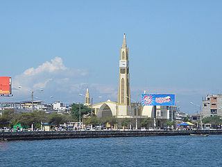
Puerto Bolívar is an urban parish and port city, part of the municipality of Machala, El Oro Province, Ecuador. Puerto Bolívar is one of the world's largest shipment points for bananas, most of them destined for Europe; about 80% of Ecuador's banana production is shipped through these port facilities.

<span class="mw-page-title-main">Chone, Ecuador</span> Town in the province of Manabí in Ecuador

Chone is a town in the province of Manabí in Ecuador. Officially, La Real Santisíma Villa Rica de la Bendita Providencia de San Cayetano de Chone de esta nuestra Nueva Castilla in reference to Saint Cajetan and The City of Kings, called Pueblo Viejo de Chone or Señorío de Pechance was founded in the early days of the colonization. It is located in Ecuador's low-lying coastal region and plays an important CHONE transportation hub. It is about seven hours by bus from the capital city of Quito.

<span class="mw-page-title-main">Machala Canton</span> Canton in El Oro Province, Ecuador

Machala Canton is a canton of Ecuador, located in the El Oro Province. Its capital is the town of Machala. Its population at the 2001 census was 217,696.

<span class="mw-page-title-main">Palestina Canton</span> Canton in Guayas Province, Ecuador

Palestina is a town located in northern Guayas, Ecuador. It is the seat of Palestina Canton, created in 1988. Palestina currently has 16,065 inhabitants, and its nearby cities are Santa Lucía, Daule, Colimes and Balzar. This town is located 80 km from Guayaquil, at the Northern Centre of the province; in other words, it is located 75 km from the capital province. This town occupies a territory of approximately 300 km2.

<span class="mw-page-title-main">Pedro Carbo Canton</span> Canton in Province of Guayas, Ecuador

Pedro Carbo Canton is a land-locked coastal canton located in Guayas Province in Ecuador, near Manabí Province. Its capital is the town of Pedro Carbo. It is located at the 63 kilometer marker on the road from Guayaquil to Manabí. It is the seat of Pedro Carbo Cantón, founded in 1984. As of the census of 2001, there are 36,711 people residing within canton limits. A new census was conducted in 2010 but results are yet unknown. The city is named after Pedro Carbo Noboa, a 19th-century politician, diplomat and writer from Guayaquil.

<span class="mw-page-title-main">Playas Canton</span> Canton in Guayas Province, Ecuador

General Villamil, also known as Playas, is a Guayas canton in Ecuador. The Playas canton is located at the south western area of the Guayas Province. Its Canton Capital is General José de Villamil, also known as Playas. It is located 96 kilómeters from the capital of the Guayas Province, Guayaquil. It borders to the north and east with Guayaquil Canton, on the west with Santa Elena Province, and to south with the Pacific Ocean. Its territory has an area of 280 square kilometres and has a population of 31,000 citizens, with 25,000 of them living in the canton's capital.

<span class="mw-page-title-main">Buena Fe Canton</span> Canton in Los Ríos Province, Ecuador

Buena Fe Canton is a canton in Los Ríos Province, Ecuador. Its capital is the town of Buena Fe. Its population at the 2001 census was 47,361.

<span class="mw-page-title-main">Pueblo Viejo Canton</span> Canton in Los Ríos Province, Ecuador

Puebloviejo Canton is a canton of Ecuador, located in the Los Ríos Province. Its capital is the town of Puebloviejo. Its population at the 2001 census was 29,420.

<span class="mw-page-title-main">Guayaquil Group</span>

The Guayaquil Group was a literary group from the 1930s - mid 1940s, that emerged as a response to a chaotic social and political climate where the Ecuadorian "montubio" and mestizo were oppressed by the elite class, priests, and the police. It was composed of five main writers: Joaquín Gallegos Lara, Enrique Gil Gilbert, Demetrio Aguilera Malta, José de la Cuadra, and Alfredo Pareja Diezcanseco. Their works aimed to portray "social realism" as a form of displaying the real Ecuadorian montubio and cholo. The group eventually disintegrates after the death of two of their writers, José de la Cuadra and Joaquín Gallegos Lara, the inactivity in literature by Enrique Gil Gilbert, and the long trips away from Ecuador by Demetrio Aguilera Malta and Alfredo Pareja Diezcanseco in the mid 1940s.

<span class="mw-page-title-main">Battle of Zarumilla</span> Battle of the 1941 Ecuadorian–Peruvian War

The Battle of Zarumilla was a military confrontation between Peru and Ecuador that took place from July 23 to 31 during the 1941 Ecuadorian–Peruvian War.

References

  1. Citypopulation.de Population and area of El Guabo Canton
  2. "Resultados".