![]() |
Riobamba Canton | |
---|---|
Tungurahua volcano as seen from Riobamba | |
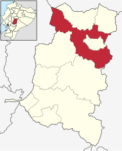
![]() Riobamba Canton in Chimborazo Province | |
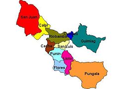
Parishes of Riobamba Canton | |
Coordinates: 1°40′27.65″S78°38′53.86″W / 1.6743472°S 78.6482944°W | |
Country | ![]() |
Province | ![]() |
Capital | Riobamba |
Area | |
• Total | 997.9 km2 (385.3 sq mi) |
Population (2022 census) [1] | |
• Total | 260,882 |
• Density | 260/km2 (680/sq mi) |
Time zone | UTC-5 (ECT) |
Riobamba Canton is one of ten cantons of the Chimborazo Province in Ecuador. Its population at the 2010 census was 225,741. [2] Its capital is the town of Riobamba.
The canton is divided into 16 parishes, five urban parishes, Lizarzaburu, Maldonado, Velasco, Veloz and Yaruquíes, and eleven rural parishes: Cacha, Calpi, Cubijíes, Flores, Licán, Licto, Pungalá, Punín, Químiag, San Juan and San Luís.
Parish | Inhabitants (2010) [3] |
---|---|
Total | 225,741 |
Riobamba (urban) | 156,723 |
Rural area | 69,018 |
Cacha Parish | 3,160 |
Calpi Parish | 6,469 |
Cubijíes Parish | 2,514 |
Flores Parish | 4,546 |
Licán Parish | 7,963 |
Licto Parish | 7,807 |
Pungalá Parish | 5,954 |
Punín Parish | 5,976 |
Químiag Parish | 5,257 |
San Juan Parish | 7,370 |
San Luís Parish | 12,002 |
Chimborazo is a province in the central Ecuadorian Andes. It is a home to a section of Sangay National Park. The capital is Riobamba. The province contains Chimborazo, Ecuador's highest mountain.
Esmeraldas is a northwestern coastal province of Ecuador. The capital and largest city is Esmeraldas. Esmeraldas is one of the three provinces of Ecuador that borders Colombia, and it is the most northern province in the country. The province borders Imbabura and Carchi to the east, the Pacific Ocean to the west, Manabí, Santo Domingo de los Tsáchilas and Pichincha to the south, and Colombia to the north. The province is home to the Afro-Ecuadorian culture.
Los Ríos is a province in Ecuador. The capital is Babahoyo. The province was founded on October 6, 1860. Under legislative decree. Babahoyo was made its capital on September 30, 1948.
Cotacachi is a canton of Imbabura province of Ecuador in South America. The name also refers to Cotacachi, the seat of that canton, which is one of Ecuador's leading artisanal manufacturers of leather goods, and to the dormant Cotacachi Volcano which overlooks the canton.
Chaguarpamba is a canton in the Province of Loja Ecuador. Its seat is Chaguarpamba. The canton is located in the north of the province and is bordered by the cantons of Catamayo, Olmedo, Paltas, and the province of El Oro. The name is Quichua for "Valley of Jaguars." It occupies an area of 313.4 km2 at an altitude of 1050 m, with a population of 6,857. Average temperature is between 18 and 24 °C
The Province of Santa Elena is a province of Ecuador in the coastal region. Created in 2007 from territory that belonged to the Guayas Province, it is one of the two newest provinces of Ecuador, along with Santo Domingo de Los Tsáchilas. Its capital city is Santa Elena, from which the province derives its name.
Cajabamba is a location in the Chimborazo Province, Ecuador. It is the seat of the Colta Canton.
Guamote is a town in the Chimborazo Province, Ecuador. It is the seat of the Guamote Canton.
Alausí Canton is a canton in the Chimborazo Province in Ecuador. Its seat is Alausí. The canton is being promoted as a tourist region, and was named a Pueblo Mágico by the Ecuadorian Ministry of Tourism (MINTUR) in 2019.
Guachapala is a canton in the province of Azuay, Ecuador, was created in the presidency of the Architect Sixto Durán Ballén according to the Supplement to Official Gazette No. 623 of January 31, 1995. According to the last census conducted by the INEC, its population is approximately 3409 people, is famous for the religious shrine of Lord Andacocha, so many tourists get religious.
Las Naves Canton is a canton of Ecuador, located in the Bolívar Province. Its capital is the town of Las Naves. Its population at the 2001 census was 5,265.
Espejo is a canton of Ecuador, located in Carchi Province. Its capital is the town of El Ángel. Its population in the 2001 census was 13,515 and in the 2010 census was 13,364. Espejo is located in the Andes and El Ángel is situated at an elevation of 3,010 metres (9,880 ft) above sea level.
Montúfar Canton is a canton of Ecuador, located in Carchi Province. Its capital is the city of San Gabriel. The canton's population in the 2001 census was 28,576 and was 30,511 in the 2010 census.
San Pedro de Huaca Canton is a canton of Ecuador, located in Carchi Province. Its capital is the town of Huaca. Its population in the 2001 census was 6,856 and in 2010 was 7,624. The area is 31 square kilometres (12 sq mi).
Nobol Canton is a canton of Ecuador, located in the Guayas Province. Its capital is the town of Nobol. Its population at the 2001 census was 14,753.
Otavalo Canton is a canton of Ecuador, located in Imbabura Province. Its capital is the city of Otavalo. The Canton's population in the 2010 census was 104,874 compared to 90,188 in the 2001 census. Its area is 530.5 square kilometres (204.8 sq mi). Indigenous people, especially the Otavalo people, make up 57 percent of the total population.
Pimampiro Canton is a canton of Ecuador, located in Imbabura Province. Its population in the 2001 census was 12,951 and 12,970 in the 2010 census.
Saraguro is a canton of Ecuador, located in Loja Province. Its capital is the town of Saraguro. The area of the canton is 1,085 square kilometres (419 sq mi). The capital of the canton is the parish and town of Saraguro.
El Carmen Canton is a canton of Ecuador, located in the Manabí Province. Its capital is the town of El Carmen. Its population at the 2001 census was 69,998.
Francisco de Orellana Canton is a canton of Ecuador, located in the Orellana Province. Its capital is the town of Puerto Francisco de Orellana. Its population at the 2001 census was 42,010.