Cañar is a province in Ecuador. The capital is Azogues. At the time of census 2010 the province had a population of 225,184. It contains the 16th-century ruins of Ingapirca, the best-known Inca settlement in Ecuador and a product of their conquest of the indigenous Cañari.

Carchi is a province in Ecuador. The capital is Tulcán. The Carchi River rises on the slopes of Chiles volcano and forms the boundary between Colombia and Ecuador near Tulcan. Rumichaca Bridge is the most important land route between Colombia and Ecuador.

Chimborazo is a province in the central Ecuadorian Andes. It is a home to a section of Sangay National Park. The capital is Riobamba. The province contains Chimborazo, Ecuador's highest mountain.

Imbabura is a province located in the Andes of northern Ecuador. The capital is Ibarra. The people of the province speak Spanish and the Imbaburan Quechua language.

Pichincha is a province of Ecuador located in the northern sierra region; its capital and largest city is Quito. It is bordered by Imbabura and Esmeraldas to the north, Cotopaxi and Santo Domingo de los Tsáchilas to the south, Napo and Sucumbíos to the east, and Esmeraldas and Santo Domingo de los Tsáchilas to the west.

Cotacachi is a canton of Imbabura province of Ecuador in South America. The name also refers to the city which is the seat of that canton, one of Ecuador's leading artisanal manufacturers of leather goods, and to the dormant Cotacachi Volcano which overlooks the canton.

Pedro Moncayo is a canton in the north of the Pichincha Province, Ecuador. The seat of the canton is the city of Tabacundo. The canton is named after politician Pedro Moncayo. The canton is separated by the Mojanda volcano from the canton of Otavalo in the province of Imbabura in the north. It borders the same-province cantons of Cayambe and Quito.
San Miguel de los Bancos, or simply Los Bancos, is a canton in the province of Pichincha, Ecuador. The long name of the town refers to dedication of the area to the archangel Michael. Local tradition attributes the "Los Bancos" part of the name to the use of tree trunks as benches at the junction of the through road from Quito to Esmeraldas with the road into the Rio Blanco valley.

Rumiñahui or Rumiñawi is a canton of Pichincha Province in Ecuador. Its seat is Sangolquí. The canton lies southeast of Quito Canton and forms a suburb of Quito.
Zamora is a canton in the Zamora-Chinchipe Province of Ecuador. It was named after Zamora city, the provincial capital and head of the canton of the same name.

El Pan Canton is a canton of Ecuador, located in the Azuay Province. Its capital is the town of El Pan. Its population at the 2001 census was 3,075.
Sevilla de Oro Canton is a canton of Ecuador, located in the Azuay Province. Its capital is the town of Sevilla de Oro. Its population at the 2001 census was 5,234.

Bolívar Canton is a canton of Ecuador, located in Carchi Province. Its capital is the town of Bolívar. Its population at the 2001 census was 13,898 and in 2010 was 14,347.

Las Lajas Canton is a canton of Ecuador, located in the El Oro Province. Its capital is the town of La Victoria. Its population at the 2001 census was 4,781.

Ibarra Canton is a canton of Ecuador, located in Imbabura Province. Its capital is the town of Ibarra. Its population in the 2001 census was 153,256 and 181,175 in the 2010 census. The area of the canton is 1,093 square kilometres (422 sq mi).
San Miguel de Urcuquí Canton, or Urkuki, is a canton of Ecuador, located in the Imbabura Province. Its seat is the town of Urcuquí. Its population in the 2001 census was 14,381 and was 15,671 in the 2010 census. The area of the canton is 779 square kilometres (301 sq mi).

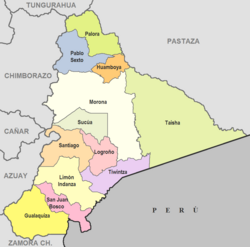
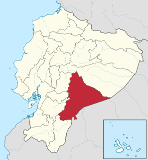
Morona Canton is a canton of Ecuador, located in the Morona-Santiago Province. Its capital is the town of Morona. Its population at the 2001 census was 5,065.
Pelileo Canton is a canton of Ecuador, located in the Tungurahua Province. Its capital is the town of Pelileo. Its population at the 2001 census was 48,988.

Nangaritza Canton is a canton of Ecuador, located in the Zamora-Chinchipe Province. Its capital is the town of Nangaritza. Its population at the 2001 census was 4,797.
Yacuambi Canton is a canton of Ecuador, located in the Zamora-Chinchipe Province. Its capital is the town of Yacuambi. Its population at the 2001 census was 5,229.