
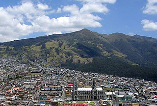
Quito, officially the Metropolitan District of Quito, is a canton in the province of Pichincha, Ecuador.
Cayambe is a canton in the northeast of the province of Pichincha, in northern Ecuador, South America. The canton is named after the Cayambe, a 5,800-meter-high snow-covered stratovolcano in the east of the canton. The main part of the canton occupies the eastern portion of the Pisque river basin and is surrounded by volcanoes.
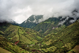
Mejía is a canton in the province of Pichincha in northern Ecuador. It is named after Ecuadorian political figure José Mejía Lequerica. The canton includes a volcano in the Central Cordillera of the Ecuadorian Andes called Rumiñahui. The seat of the canton is called Machachi.
Pedro Moncayo is a canton in the north of the Pichincha Province, Ecuador. The seat of the canton is the city of Tabacundo. The canton is named after politician Pedro Moncayo. The canton is separated by the Mojanda volcano from the canton of Otavalo in the province of Imbabura in the north. It borders the same-province cantons of Cayambe and Quito.
San Miguel de los Bancos, or simply Los Bancos, is a canton in the province of Pichincha, Ecuador. The long name of the town refers to dedication of the area to the archangel Michael. Local tradition attributes the "Los Bancos" part of the name to the use of tree trunks as benches at the junction of the through road from Quito to Esmeraldas with the road into the Rio Blanco valley.

Rumiñahui or Rumiñawi is a canton of Pichincha Province in Ecuador. Its seat is Sangolquí. The canton lies southeast of Quito Canton and forms a suburb of Quito.

Puerto Quito is a town and urban parish in the province of Pichincha, Ecuador. The town is a developing area for ecotourism, thanks to an abundance of wildlife, secondary jungle and beautiful waterfalls such as the Cascada Azul. Puerto Quito is situated beside a major bridge over the river Caoní on the main road from Quito to the coast. By road, Quito is 140 km or 3.5 hours by bus.

Reserva Geobotánica Pululahua is a protected area around Pululahua Volcano in the north of Quito Canton, Pichincha Province, Ecuador. It is 17 km north of Quito, in the northwestern part of the Pomasqui Valley. The most notable feature of this site is "el cráter de Pululahua", which is one of only two volcanic craters in the world inhabited by humans. Often, this reserve is shrouded in a thick layer of clouds or fog. The land here is extremely fertile because it is volcanic (igneous) soil and, as mentioned earlier, is used to cultivate crops.
La Libertad is an urban parish in the city of Quito, Ecuador. It is located in the southern part of the city, just south of the city center and on the slopes of the Pichincha volcano.
Lloa is a rural parish of Quito Canton, Pichincha Province, Ecuador. The seat of the parish, which is the village of Lloa, lies west of the southern part of the city of Quito and approximately southeast of Guagua Pichincha Volcano, surrounded by some foothills of the Pichincha Volcano.
San Antonio de Pichincha, or simply San Antonio and less frequently by the older name San Antonio de Lulumpamba, is a rural parish of Quito Canton, Pichincha Province, Ecuador. The seat of the parish lies in an arid plain with sandy soil known as Lulumpamba. The Quechua language name of the plain means plain of fruit(s). It is southeast of Pululahua (Pululagua) Volcano and east of Casitagua Volcano. In the village there is also a Lulumpamba street named after the plain.
Calderón is a rural parish of Quito Canton, Pichincha Province, Ecuador. It lies northeast of the city of Quito, on Ecuador Highway 35, a north-to-south-running highway which is the Ecuadorian segment of the Pan-American Highway.
Itchimbía is a hill in Quito, Pichincha Province, Ecuador. It is surrounded to the east by Machángara River, a river that originates in the southern part of the city of Quito. Itchimbía is on the eastern/northeastern border of the center (downtown) of the city of Quito and the southeast border of the northern part.
Ilaló is a volcano between San Pedro River to the west and Chiche River to the east, in Quito Canton, Pichincha Province, Ecuador. Ilaló is surrounded by the rural parishes Cumbayá, Tumbaco, La Merced and Alangasí.
Puengasí is a hill towards the southeast of the center of the city of Quito, Pichincha Province, Ecuador, across Machángara River, and southeast of Itchimbía. It is northwest of the rural parish Conocoto.

Casitahua is a dormant, eroded volcano in the north of Quito Canton, Pichincha Province, Ecuador. The volcano is in the Western Cordillera of the northern Ecuadorian Andes, between Pululagua Volcano to the north and Pichincha Volcano approximately to the southwest. Casitahua's caldera is open approximately towards the west-northwest.
Píntag is an agrarian village located 27.5 kilometers southeast of Quito in Pichincha Province, Ecuador.

La Concordia Canton is a canton of Ecuador. It shares borders with the cantons of El Carmen, Chone, Pedernales, Puerto Quito, Quinindé, and Santo Domingo, which are part of the provinces of Manabí, Pichincha, Esmeraldas, and Santo Domingo de los Tsáchilas, respectively. Its capital is the town of La Concordia. Elections on whether to form part of one of those two provinces took place on February 5, 2012. The final resolution was to become part of Santo Domingo de los Tsáchilas Province, thus becoming the 2nd Canton of that province.
Nono is a rural parish in the municipality of Quito in the Province of Pichincha, Ecuador.

Ecuador Department was one of the departments of Gran Colombia created in 1824.


