
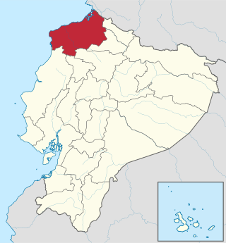
Carchi is a province in Ecuador. The capital is Tulcán. The Carchi River rises on the slopes of Chiles volcano and forms the boundary between Colombia and Ecuador near Tulcan. Rumichaca Bridge is the most important land route between Colombia and Ecuador.
Esmeraldas is a province in northwestern Ecuador. The capital is Esmeraldas.

Los Ríos is a province in Ecuador. The capital is Babahoyo. The province was founded on October 6, 1860. Under legislative decree. Babahoyo was made its capital on September 30, 1948.

Orellana is an inland province of Ecuador. The capital is Puerto Francisco de Orellana. It was created on July 30, 1998, from part of Napo Province.

Sucumbíos is a province in northeast Ecuador. The capital and largest city is Nueva Loja. It is the fifth largest province in the country, with an area of 18,084 km2. In 2010, it had a population of 176,472 inhabitants.
The Secoya are an indigenous peoples living in the Ecuadorian and Peruvian Amazon. They speak the Secoya language Pai Coca, which is part of the Western Tucanoan language group. In Ecuador the Secoya number about 400 people who for the most part are located in three settlements, Eno, San Pablo de Katitsiaya and Siecoya Remolino, all found on the banks of the Aguarico river. Their Ecuadorian territory covers 40.000 hectares along the Shushufindi, Aguarico, and Cuyabeno river in the state of Sucumbios. Until recently they shared territory with the Siona people, with whom they are sometimes considered a single population, although both peoples have independent governance. In Peru the Secoya population numbers about 700.

The Province of Santa Elena is a province of Ecuador in the coastal region. Created in 2007 from territory that belonged to the Guayas Province, it is one of the two newest provinces of Ecuador, along with Santo Domingo de Los Tsáchilas. Its capital city is Santa Elena, from which the province derives its name.

The Cuyabeno Wildlife Reserve is the second largest reserve of the 56 national parks and protected areas in Ecuador. It is located in the Putumayo Canton in the Sucumbíos Province and in the Aguarico Canton in the Orellana Province. It was decreed on 26 July 1979 as part of the creation of the national protected areas system based on the recommendations of the FAO report on the "National Strategy on the Conservation of Outstanding Wild Areas of Ecuador".

Nuevo Rocafuerte is a town in Ecuador. The capital of Aguarico Canton in Orellana Province, it was founded in 1942 as a result of a battle which displaced the inhabitants of the original settlement and subsequent border agreements which made this location a key border spot on the border with Peru.

Alfredo Baquerizo Moreno is a canton of the province of Guayas in the Republic of Ecuador. Its official name was given in honor of Alfredo Baquerizo Moreno, who served three times as the president of Ecuador. It is also known as Juján, a name which came from a regional plant. The canton covers an area of 228.6 square kilometres (88.3 sq mi). Its canton seat is also known as Alfredo Baquerizo Moreno or Juján.
Guachapala is a canton in the province of Azuay, Ecuador, was created in the presidency of the Architect Sixto Durán Ballén according to the Supplement to Official Gazette No. 623 of January 31, 1995. According to the last census conducted by the INEC, its population is approximately 3409 people, is famous for the religious shrine of Lord Andacocha, so many tourists get religious.

Las Naves Canton is a canton of Ecuador, located in the Bolívar Province. Its capital is the town of Las Naves. Its population at the 2001 census was 5,265.

San Pedro de Huaca Canton is a canton of Ecuador, located in Carchi Province. Its capital is the town of Huaca. Its population in the 2001 census was 6,856 and in 2010 was 7,624. The area is 31 square kilometres (12 sq mi).

Atacames Canton is a canton of Ecuador, located in the Esmeraldas Province. Its capital is the town of Atacames. Its population at the 2001 census was 30,267.
Otavalo Canton is a canton of Ecuador, located in Imbabura Province. Its capital is the city of Otavalo. The Canton's population in the 2010 census was 104,874 compared to 90,188 in the 2001 census. Its area is 530.5 square kilometres (204.8 sq mi). Indigenous people, especially the Otavalo people, make up 57 percent of the total population.

El Carmen Canton is a canton of Ecuador, located in the Manabí Province. Its capital is the town of El Carmen. Its population at the 2001 census was 69,998.
Rocafuerte Canton is a canton of Ecuador, located in the Manabí Province. Its capital is the town of Rocafuerte. Its population at the 2001 census was 29,321.

Francisco de Orellana Canton is a canton of Ecuador, located in the Orellana Province. Its capital is the town of Puerto Francisco de Orellana. Its population at the 2001 census was 42,010.
The Battle of Pantoja and Rocafuerte, known also simply as the Battle of Rocafuerte, was a military confrontation between Peru and Ecuador that took place on August 11, 1941, during the Ecuadorian–Peruvian War.

Cabo Pantoja, formerly Rocafuerte and Pantoja, is a town in the Torres Causana District of the Loreto Department in Peru.


