
The Pastaza River is a large tributary to the Marañón River in the northwestern Amazon Basin of South America.

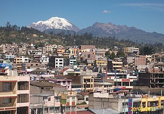
Tungurahua is one of the twenty-four provinces of Ecuador. Its capital is Ambato. The province takes its name from the Tungurahua volcano, which is located within the boundaries of the provinces.
Cotacachi is a canton of Imbabura province of Ecuador in South America. The name also refers to Cotacachi, the seat of that canton, which is one of Ecuador's leading artisanal manufacturers of leather goods, and to the dormant Cotacachi Volcano which overlooks the canton.
Sangolquí is a suburb of Quito and the seat of Rumiñahui canton in the province of Pichincha, in northern Ecuador. It is connected to Quito by the Autopista General Rumiñahui.

Rumiñahui or Rumiñawi is a canton of Pichincha Province in Ecuador. Its seat is Sangolquí. The canton lies southeast of Quito Canton and forms a suburb of Quito.

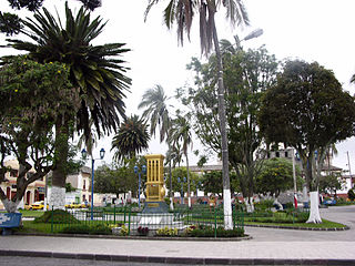
Alausí is a town in the Chimborazo province of Ecuador.

San Gabriel is a name of the capital city of San Gabriel parish in Montúfar Canton in Carchi Province of Ecuador. The city and parish are located in the Andes, at an elevation of 2,878 metres (9,442 ft) above sea level.

Cotacachi is a town that is the seat of Cotacachi Canton, Imbabura Province, Ecuador, in South America. Cotacachi is located at an altitude of 2,418 metres (7,933 ft) and had a population of 8,848 in 2010.

Llanganates National Park is a protected area in Ecuador situated in the Cotopaxi Province, Napo Province, Pastaza Province and Tungurahua Province. Located within the park is Cerro Hermoso, a 4,570 meters (14,990 ft) high peak that is a popular hiking destination. The park is famous for the Treasure of the Llanganatis.
Alausí Canton is a canton in the Chimborazo Province in Ecuador. Its seat is Alausí. The canton is being promoted as a tourist region, and was named a Pueblo Mágico by the Ecuadorian Ministry of Tourism (MINTUR) in 2019.

Patate is a town in Ecuador in the Tungurahua Province in northwestern South America between San Juan de Ambato and Baños. It is located close to the foothills of the still active Tungurahua volcano.

Zaruma Canton is a canton of Ecuador, located in the El Oro Province. Its capital is the town of Zaruma. Its population at the 2001 census was 23,407.

Baños Canton is a canton of Ecuador, located in the Tungurahua Province. Its capital is the town of Baños. The population of Baños Canton at the 2010 census was 20,018., and in 2011 its population had risen to 21,140
El Cantón Cevallos is a canton of Ecuador, located in the Tungurahua Province. Its capital is the town of Cevallos. Its population at the 2001 census was 6,873.
Mocha Canton is a canton of Ecuador, located in the Tungurahua Province. Its capital is the town of Mocha. Its population at the 2001 census was 6,371.
Pelileo Canton is a canton of Ecuador, located in the Tungurahua Province. Its capital is the town of Pelileo. Its population at the 2001 census was 48,988.
Píllaro Canton is a canton of Ecuador, located in the Tungurahua Province. Its capital is the town of Píllaro. Its population at the 2001 census was 34,925.
Quero Canton is a canton of Ecuador, located in the Tungurahua Province. Its capital is the town of Quero. Its population at the 2001 census was 18,187.
Tisaleo Canton is a canton of Ecuador, located in the Tungurahua Province. Its capital is the town of Tisaleo. Its population at the 2001 census was 10,525.
The Programa Pueblos Mágicos is an initiative led by Ecuador's Ministry of Tourism (MINTUR). The program seeks to promote tourism in a network of small and mid-sized towns that represent aspects of Ecuador's cultural heritage, and to encourage sustainable economic development in these communities. It is based on the Mexican government's program of the same name.

