Pasaje Canton

Last updated
Pasaje Canton
Nickname: 
"Pasaje de las nieves"
MapaSageo-Ecuador-El Oro.png
Location of El Oro Province in Ecuador.
Cantones de El Oro.png
Cantons of El Oro Province
Coordinates: 3°19′37″S79°48′18″W / 3.3269°S 79.8049°W / -3.3269; -79.8049
CountryFlag of Ecuador.svg  Ecuador
Province El Oro Province
Capital Pasaje
Area
  Total456.1 km2 (176.1 sq mi)
Population
 (2022 census) [1]
  Total83,597
  Density180/km2 (470/sq mi)
Time zone UTC-5 (ECT)

Pasaje Canton is a canton of Ecuador, located in the El Oro Province, in the coastal region. Its capital is the town of Pasaje, where much of its population lies. Its population at the 2001 census was 62,959. [2]

Contents

History

In the year 1758, the Governor of Machala, the indigenous Ambrosio Gomal, with a group of indigenous people, negotiated with the government of Guayaquil in defense of the site of Pasaje against the onslaught of land auctioneers. The land judge at that time, Captain Antonio de Argote, ceded the land to the indigenous people from Machala on the condition that in two and a half years, they would make it a town, otherwise the land would be returned to his Majesty the king of Spain.

The first settlers established themselves in what is now Guaboplaya and Mollopongo, down the river from current-day Pasaje. It is known that there was a path that descended from the highlands and arrived at the “Chaguana” ranch, and onto this main path connected a road originating in Pucará, which passed through land belonging to el señor Núñez and an area called Las Nieves, which is where the name “Pasaje de las Nieves” comes from.

This first settlement was founded around 1760, but they were faced with harsh weather and had difficulty connecting to Machala due to the constant rising of the Jubones River —in Quechua, “devourer of men”— so they were forced to move to another place. They settled in Uzhcaplaya, on the opposite bank of the river, around 1780, and stayed until 1800 when approximately 100 residents, despite the ease of work, were tired of the unexpected scourges of the tumultuous river and turned to a new settlement in what is now Pasaje Cantón. So the story was told in 1822 when Mr. Gabino Serrano, great grandfather of Andrés Corsino García, had the fortune of lodging the Marshal Antonio José de Sucre in his house as he advanced with the liberating troops, who sealed the independence of the country in the Victory of Pichincha on May 24 of the same year.

With the law of territorial division in 1824, Machala was declared a cantón, making Pasaje a parish of Machala. Pasaje grew rapidly with the immigration of people from Cuenca, Loja and Zaruma, attracted by the fertility of its land and notable progress.

In 1890, the idea of independence from Machala began to germinate, with the goal of political and economic liberty through cantonization. The president of Ecuador, Dr. Luis Cordero, had denied Pasaje the designation of cantón out of resentment for its lack of support in the elections that made him president. The priest Dr. José Ochoa León, the deputy for El Oro Province in that year, and a close friend of President Cordero, was the one who finally made possible the cantonization of Pasaje in 1894.

Territorial Organization

The city and canton of Pasaje, like other Ecuadorian localities, is governed by a municipality as stipulated in the National Political Constitution. The Municipality of Pasaje is a sectional government entity that governs the canton autonomously from the central government. The municipality is organized by a separation of powers with the executive component represented by the mayor, and the legislative component formed by the members of the cantonal council. The mayor is the highest administrative and political authority of Pasaje Canton. They are the head of the city council and representative of the Municipality.

The Canton is divided into parishes, whether urban or rural, which are represented by the Parish Boards before the Municipality of Pasaje.

Urban Parishes

Rural Perishes

Demographics

Ethnic groups as of the Ecuadorian census of 2010: [3]

Related Research Articles

<span class="mw-page-title-main">Machala</span> City in El Oro, Ecuador

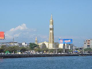
Machala is a city in south-west Ecuador. It is the capital of the El Oro Province, and is located near the Gulf of Guayaquil on fertile lowlands. Machala has a population of 288,072 ; it is the sixth-biggest city in the country, and the second-most important port. It has been referred to as the Banana Capital of the World.

<span class="mw-page-title-main">El Oro Province</span> Province of Ecuador

El Oro is the southernmost of Ecuador's coastal provinces. It was named for its historically important gold production. Today it is one of the world's major exporters of bananas. The capital is Machala.

<span class="mw-page-title-main">Zamora-Chinchipe Province</span> Province of Ecuador

Zamora Chinchipe, Province of Zamora Chinchipe is a province of the Republic of Ecuador, located at the southeastern end of the Amazon Basin, which shares borders with the Ecuadorian provinces of Azuay and Morona Santiago to the north, Loja and Azuay to the west, and with Peru to the east and south. The province comprises an area of approximately 10,559 km² and is covered with a uniquely mountainous topography which markedly distinguishes it from the surrounding Amazonian provinces. Zamora-Chinchipe is characterized and largely identified by its mining industry; indigenous ethnic groups with a rich archaeological legacy; its biodiversity; and its niche and tourist attractions, which include a number of waterfalls well-noted for their beauty. The province takes its name from the bureaucratic fusion of the Zamora and Chinchipe cantons. The provincial capital is the city of Zamora.

<span class="mw-page-title-main">Ecuadorian–Peruvian War</span> 1941 South American border conflict

The Second Ecuadorian–Peruvian War, known locally as the War of '41, was a South American border war fought between 5–31 July 1941. It was the first of three military conflicts between Ecuador and Peru during the 20th century.

<span class="mw-page-title-main">Balao</span> City in Ecuador

Balao is a town located in southern Guayas, Ecuador, near Azuay and El Oro provinces. It is the seat of Balao Canton, created in 1987.

<span class="mw-page-title-main">Zaruma</span> Town in El Oro Province, Ecuador

Zaruma, officially Villa Real de San Antonio del Cerro de Oro de Zaruma is a town in the south of Ecuador, El Oro Province. It is located in the south-east of this province, at an altitude of 1200 metres above sea level, on an inter-Andes route where the Vizcaya mountain range branches off from the Chilla mountain range. It is the seat of Zaruma Canton, one of the oldest cantons in the province.

<span class="mw-page-title-main">Guayaquil Canton</span> Canton in Ecuador

The Guayaquil Canton, officially the Municipality of Guayaquil, is a canton in the center of the Guayas Province in western Ecuador. The canton was named after its seat, the city of Guayaquil, the most populous city in Ecuador.

<span class="mw-page-title-main">Ecuadorian–Peruvian territorial dispute</span>

The Ecuadorian–Peruvian territorial dispute was a territorial dispute between Ecuador and Peru, which, until 1928, also included Colombia. The dispute had its origins on each country's interpretation of what Real Cedulas Spain used to precisely define its colonial territories in the Americas. After independence, all of Spain's colonial territories signed and agreed to proclaim their limits in the basis of the principle of uti possidetis juris, which regarded the Spanish borders of 1810 as the borders of the new republics. However, conflicting claims and disagreements between the newly formed countries eventually escalated to the point of armed conflicts on several occasions.

<span class="mw-page-title-main">Balsas Canton</span> Canton in El Oro Province, Ecuador

Balsas is a canton in the Province of El Oro in Ecuador. The name of the canton is due to the abundant amount of balsa trees that existed in this area. The customs and traditions in Balsas are based on the influence brought by the first settlers from the Cantón Piñas, Zaruma, and part of the Province of Loja. Balsas is a privileged town, its location, natural resources, and economic conditions are unique conditions that have allowed it to aim towards development.

<span class="mw-page-title-main">Puerto Bolívar</span> Port city in Ecuador

Puerto Bolívar is an urban parish and port city, part of the municipality of Machala, El Oro Province, Ecuador. Puerto Bolívar is one of the world's largest shipment points for bananas, most of them destined for Europe; about 80% of Ecuador's banana production is shipped through these port facilities.

<span class="mw-page-title-main">Tulcán Canton</span> Canton in Carchi Province, Ecuador

Tulcán Canton is a canton of Ecuador, located in Carchi Province. Its capital is the city of Tulcán. The population of the canton in the 2001 census was 77,175 and 86,498 in the 2010 census. The area of the canton is 1,812 square kilometres (700 sq mi).

<span class="mw-page-title-main">El Guabo Canton</span> Canton in El Oro Province, Ecuador

The Guabo is a canton in the province of El Oro in Ecuador. Its capital is the city cantonal Guabo. Its population in the 2010 census was 50,009 inhabitants. The date of canton of El Guabo was September 7, 1978. The mayor for the period 2009-2014 was John Franco Aguilar.

<span class="mw-page-title-main">Las Lajas Canton</span> Canton in El Oro Province, Ecuador

Las Lajas Canton is a canton of Ecuador, located in the El Oro Province. Its capital is the town of La Victoria. Its population at the 2001 census was 4,781.

<span class="mw-page-title-main">Machala Canton</span> Canton in El Oro Province, Ecuador

Machala Canton is a canton of Ecuador, located in the El Oro Province. Its capital is the town of Machala. Its population at the 2001 census was 217,696.

<span class="mw-page-title-main">Durán Canton</span> Canton in Guayas Province, Ecuador

Durán Canton is a canton of Ecuador, located in the Guayas Province. Its capital is the city of Durán. Its population at the 2001 census was 178,714.

<span class="mw-page-title-main">Ventanas Canton</span> Canton in Los Ríos Province, Ecuador

Ventanas Canton is a canton of Ecuador, located in the Los Ríos Province. Its capital is the town of Ventanas. Its population at the 2001 census was 71,145.

<span class="mw-page-title-main">Marcel Jacobo Laniado de Wind</span> Ecuadorian agricultural engineer and banker

Marcel Jacobo Laniado de Wind was an Ecuadorian agricultural engineer and banker who held a number of important public and private positions in Ecuador. He was a humanist, and a public figure in Ecuador for his efforts to improve the country.

<span class="mw-page-title-main">Poly Ugarte</span> Ecuadorian activist, lawyer, and politician

Blanca Rosana Ugarte Guzmán, better known as Poly Ugarte, is an Ecuadorian activist, lawyer, and politician.

<span class="mw-page-title-main">Peruvian occupation of Ecuador</span> Military occupation of Ecuador (1941–1942)

The Peruvian occupation of Ecuador was the military occupation by the Peruvian Army of the southern provinces of Ecuador that lasted from 1941 to 1942, during the Ecuadorian–Peruvian War. After a ceasefire was declared on July 31, 1941, the civil administration became limited to the provinces of El Oro and Loja until the Rio Protocol was signed on January 29, 1942, with Peruvian troops withdrawing on February 12.

<span class="mw-page-title-main">Oswaldo Patricio Vintimilla Cabrera</span> Roman Catholic Bishop of Azogues

Oswaldo Patricio Vintimilla Cabrera, is an Ecuadorian priest, who serves as the Bishop of Azogues.

References

  1. Citypopulation.de Population and area of Pasaje Canton
  2. Cantons of Ecuador at statoids.com
  3. "Resultados".