San Antonio de Pichincha

Last updated
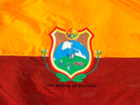
Flag of San Antonio de Pichincha BanderaSAP.jpg
Flag of San Antonio de Pichincha
Coat of Arms of San Antonio de Pichincha Escudosap.jpg
Coat of Arms of San Antonio de Pichincha
Mapa Parroquia San Antonio (Quito).svg

San Antonio de Pichincha, or simply San Antonio and less frequently by the older name San Antonio de Lulumpamba (alternate spelling: Lulumbamba), is a rural parish of Quito Canton, Pichincha Province, Ecuador. The seat of the parish lies in an arid plain with sandy soil known as Lulumpamba. The Quechua language name of the plain means plain of fruit(s). It is southeast of Pululahua (Pululagua) Volcano and east of Casitagua Volcano. In the village there is also a Lulumpamba street named after the plain.

In San Antonio there is a textile factory known as La Internacional. To the west of the village there is an ethnographic museum near the equator in a touristic place known as Ciudad Mitad del Mundo and which is owned by the Prefecture of Pichincha. There is also a go-karting place known as Cartódromo Dos Hemisferios.

The Inca pucara (stone fortress) of Rumicucho is located at the eastern edge of the city.

Climate

Climate data for San Antonio de Pichincha, elevation 2,430 m (7,970 ft), (1961–1990)
MonthJanFebMarAprMayJunJulAugSepOctNovDecYear
Mean daily maximum °C (°F)23.1
(73.6)
23.2
(73.8)
22.5
(72.5)
22.2
(72.0)
22.5
(72.5)
23.5
(74.3)
24.2
(75.6)
24.6
(76.3)
24.5
(76.1)
23.7
(74.7)
24.0
(75.2)
23.6
(74.5)
23.5
(74.3)
Daily mean °C (°F)15.3
(59.5)
15.5
(59.9)
15.6
(60.1)
15.6
(60.1)
15.6
(60.1)
15.5
(59.9)
15.3
(59.5)
15.6
(60.1)
15.6
(60.1)
15.3
(59.5)
15.3
(59.5)
15.5
(59.9)
15.5
(59.9)
Mean daily minimum °C (°F)10.1
(50.2)
10.3
(50.5)
11.0
(51.8)
11.0
(51.8)
10.3
(50.5)
8.8
(47.8)
8.0
(46.4)
7.9
(46.2)
8.6
(47.5)
9.3
(48.7)
9.5
(49.1)
9.6
(49.3)
9.5
(49.2)
Average precipitation mm (inches)36.0
(1.42)
48.0
(1.89)
55.0
(2.17)
68.0
(2.68)
46.0
(1.81)
22.0
(0.87)
7.0
(0.28)
11.0
(0.43)
33.0
(1.30)
48.0
(1.89)
40.0
(1.57)
35.0
(1.38)
449
(17.69)
Source: FAO [1]

Related Research Articles

<span class="mw-page-title-main">Quito</span> Capital city in Pichincha, Ecuador

Quito, officially San Francisco de Quito, is the capital of Ecuador, with an estimated population of 2.8 million in its metropolitan area. It is also the capital of the province of Pichincha. Quito is located in a valley on the eastern slopes of Pichincha, an active stratovolcano in the Andes.

<span class="mw-page-title-main">Pichincha (volcano)</span> Volcano in north-central Ecuador

Pichincha is a stratovolcano in Ecuador. The capital Quito wraps around its eastern slopes.

<span class="mw-page-title-main">Ciudad Mitad del Mundo</span> Monument park in Ecuador

The Ciudad Mitad del Mundo is a tract of land owned by the prefecture of the province of Pichincha, Ecuador. It is located at San Antonio parish of the canton of Quito, 26 km (16 mi) north of the center of Quito. The grounds contain the Monument to the Equator, which highlights the exact location of the Equator and commemorates the eighteenth-century Franco-Spanish Geodesic Mission which fixed its approximate location; they also contain the Museo Etnográfico Mitad del Mundo, Ethnographic Museum Middle of the Earth, a museum about the indigenous people ethnography of Ecuador.

<span class="mw-page-title-main">Cayambe Canton</span> Canton in Pichincha, Ecuador

Cayambe is a canton in the northeast of the province of Pichincha, in northern Ecuador, South America. The canton is named after the Cayambe, a 5,800-meter-high snow-covered stratovolcano in the east of the canton. The main part of the canton occupies the eastern portion of the Pisque river basin and is surrounded by volcanoes.

<span class="mw-page-title-main">Mejía Canton</span> Canton in Pichincha Province, Ecuador

Mejía is a canton in the province of Pichincha in northern Ecuador. It is named after Ecuadorian political figure José Mejía Lequerica. The canton includes a volcano in the Central Cordillera of the Ecuadorian Andes called Rumiñahui. The seat of the canton is called Machachi.

<span class="mw-page-title-main">Pedro Moncayo Canton</span> Canton in Pichincha, Ecuador

Pedro Moncayo is a canton in the north of the Pichincha Province, Ecuador. The seat of the canton is the city of Tabacundo. The canton is named after politician Pedro Moncayo. The canton is separated by the Mojanda volcano from the canton of Otavalo in the province of Imbabura in the north. It borders the same-province cantons of Cayambe and Quito.

<span class="mw-page-title-main">Puerto Quito Canton</span> Canton in Pichincha, Ecuador

Puerto Quito is a canton in Pichincha Province, Ecuador. It has only one parish, the urban parish of Puerto Quito, which is also the seat of the canton.

<span class="mw-page-title-main">Los Bancos Canton</span> Canton in Ecuador

San Miguel de los Bancos, or simply Los Bancos, is a canton in the province of Pichincha, Ecuador. The long name of the town refers to dedication of the area to the archangel Michael. Local tradition attributes the "Los Bancos" part of the name to the use of tree trunks as benches at the junction of the through road from Quito to Esmeraldas with the road into the Rio Blanco valley.

<span class="mw-page-title-main">Battle of Pichincha</span> Battle of the Ecuadorian War of Independence

The Battle of Pichincha took place on 24 May 1822, on the slopes of the Pichincha volcano, 3,500 meters above sea-level, right next to the city of Quito, in modern Ecuador.

<span class="mw-page-title-main">Rumiñahui Canton</span> Canton in Pichincha Province, Ecuador

Rumiñahui or Rumiñawi is a canton of Pichincha Province in Ecuador. Its seat is Sangolquí. The canton lies southeast of Quito Canton and forms a suburb of Quito.

La Libertad is an urban parish in the city of Quito, Ecuador. It is located in the southern part of the city, just south of the city center and on the slopes of the Pichincha volcano.

Lloa is a rural parish of Quito Canton, Pichincha Province, Ecuador. The seat of the parish, which is the village of Lloa, lies west of the southern part of the city of Quito and approximately southeast of Guagua Pichincha Volcano, surrounded by some foothills of the Pichincha Volcano.

Calderón is a rural parish of Quito Canton, Pichincha Province, Ecuador. It lies northeast of the city of Quito, on Ecuador Highway 35, a north-to-south-running highway which is the Ecuadorian segment of the Pan-American Highway.

<span class="mw-page-title-main">Itchimbía</span>

Itchimbía is a hill in Quito, Pichincha Province, Ecuador. It is surrounded to the east by Machángara River, a river that originates in the southern part of the city of Quito. Itchimbía is on the eastern/northeastern border of the center (downtown) of the city of Quito and the southeast border of the northern part.

Ilaló is a volcano between San Pedro River to the west and Chiche River to the east, in Quito Canton, Pichincha Province, Ecuador. Ilaló is surrounded by the rural parishes Cumbayá, Tumbaco, La Merced and Alangasí.

<span class="mw-page-title-main">Pululahua</span> Mountain in Ecuador

Pululahua is a dormant volcano in the north of Quito Canton, Pichincha Province, Ecuador. The volcano is in the Western Cordillera of the northern Ecuadorian Andes, approximately west-southwest of Mojanda and north of Casitahua volcanoes. Pululahua's caldera is approximately 5 km wide.

<span class="mw-page-title-main">Casitahua</span> Dormant volcano in Ecuador

Casitahua is a dormant, eroded volcano in the north of Quito Canton, Pichincha Province, Ecuador. The volcano is in the Western Cordillera of the northern Ecuadorian Andes, between Pululagua Volcano to the north and Pichincha Volcano approximately to the southwest. Casitahua's caldera is open approximately towards the west-northwest.

Píntag is an agrarian village located 27.5 kilometers southeast of Quito in Pichincha Province, Ecuador.

<span class="mw-page-title-main">Tourism in Ecuador</span>

Ecuador is a nation in northwest South America known as the Republic of Ecuador. Hundreds of thousands of kinds of plants and animals can be found there as a result of the diversity of its four zones. There are roughly 1640 bird species there. Along with the 4,500 kinds of butterflies, there are also 345 reptiles, 358 amphibians, and 258 mammals. Ecuador is regarded as one of the 17 nations with the highest concentration of biodiversity on Earth. The majority of its animals and plants are found in 26 state-protected areas. It also provides gastronomy, a range of cultures and customs, and historical attractions like Quito.

Aliso, also known as Pan de Azúcar, is a 3,482-metre-high (11,424 ft) volcano in the Ecuadorian Andes to the east of Antisana volcano. The complex contains a semicircular western ridge and lava domes. The volcano has erupted rhyolites and dacites and some andesitic lava flows on a ridge above Baeza. It is covered with tundra and cloud forests. At least two eruptions of Pumayacu occurred during the Holocene; one dated 4400 years ago and another's lapilli deposits overlie a cultural horizon 2000 years old. Older eruptions have been dated at 1.15 ± 0.07 Ma and are of high-potassium types. They compromise typical arc-derived lavas with fractional crystallization and other differentiation processes.

References

  1. "World-wide Agroclimatic Data of FAO (FAOCLIM)". Food and Agriculture Organization of United Nations. Retrieved 22 June 2024.

0°00′30″S78°26′42″W / 0.00824°S 78.445129°W / -0.00824; -78.445129 You can visited http://sanantoniovirtual.com for more information