"},"width_avg":{"wt":""},"depth_avg":{"wt":""},"source1_location":{"wt":"Northeast of [[Buchet]]"},"source1_coordinates":{"wt":"{{coord|50.264087|6.358525|type:river_region:DE-RP|format=dms|display=inline,title}}"},"source1_elevation":{"wt":"ca. {{Höhe|631|DE-NHN|link=true}}"},"mouth_location":{"wt":"West of [[Pronsfeld]] into the [[Prüm (river)|Prüm]]"},"mouth_coordinates":{"wt":"{{coord|50.158514|6.332763|type:river_region:DE-RP|format=dms|display=inline}}"},"mouth_elevation":{"wt":"ca. {{Höhe|365|DE-NHN|link=true}}"},"basin_population":{"wt":""},"basin_landmarks":{"wt":"Villages:[[Buchet]],[[Bleialf]],[[Pronsfeld]]"},"progression":{"wt":"{{RPrüm}}"},"basin_size_km2":{"wt":"55.693"},"basin_size_ref":{"wt":"{{GeoQuelle|DE-RP|WW|SUFFIX=,retrieved 20 November 2015}}"},"discharge1_location":{"wt":""},"discharge1_min":{"wt":""},"discharge1_avg":{"wt":""},"discharge1_max":{"wt":""},"tributaries_right":{"wt":""},"tributaries_left":{"wt":""},"waterbodies":{"wt":""},"ports":{"wt":""},"bridges":{"wt":""},"custom_label":{"wt":"References"},"custom_data":{"wt":""},"extra":{"wt":""}},"i":0}}]}" id="mwBA">.mw-parser-output .infobox-subbox{padding:0;border:none;margin:-3px;width:auto;min-width:100%;font-size:100%;clear:none;float:none;background-color:transparent}.mw-parser-output .infobox-3cols-child{margin:auto}.mw-parser-output .infobox .navbar{font-size:100%}@media screen{html.skin-theme-clientpref-night .mw-parser-output .infobox-full-data:not(.notheme)>div:not(.notheme)[style]{background:#1f1f23!important;color:#f8f9fa}}@media screen and (prefers-color-scheme:dark){html.skin-theme-clientpref-os .mw-parser-output .infobox-full-data:not(.notheme) div:not(.notheme){background:#1f1f23!important;color:#f8f9fa}}@media(min-width:640px){body.skin--responsive .mw-parser-output .infobox-table{display:table!important}body.skin--responsive .mw-parser-output .infobox-table>caption{display:table-caption!important}body.skin--responsive .mw-parser-output .infobox-table>tbody{display:table-row-group}body.skin--responsive .mw-parser-output .infobox-table tr{display:table-row!important}body.skin--responsive .mw-parser-output .infobox-table th,body.skin--responsive .mw-parser-output .infobox-table td{padding-left:inherit;padding-right:inherit}}
Alfbach | |
---|---|
![]() | |
Location | |
Country | Germany |
State | Rhineland-Palatinate |
Reference no. | DE: 26284 |
Physical characteristics | |
Source | |
• location | Northeast of Buchet |
• coordinates | 50°15′51″N6°21′31″E / 50.264087°N 6.358525°E |
• elevation | ca. 631 m above sea level (NHN) |
Mouth | |
• location | West of Pronsfeld into the Prüm |
• coordinates | 50°09′31″N6°19′58″E / 50.158514°N 6.332763°E |
• elevation | ca. 365 m above sea level (NHN) |
Length | 22.254 km [1] |
Basin size | 55.693 km2 (21.503 sq mi) [1] |
Basin features | |
Progression | Prüm→ Sauer→ Moselle→ Rhine→ North Sea |
Landmarks | Villages: Buchet, Bleialf, Pronsfeld |
The Alfbach is a 22.3-kilometre-long (13.9 mi), orographically right-bank tributary of the Prüm in the district of Bitburg-Prüm in the German state of Rhineland-Palatinate.
The Alfbach rises in the Schneifel at a height of 631 m above sea level (NHN) . Its source lies on the northern slopes of the Schwarzer Mann (697.8 m above NHN [2] ) about three kilometres northeast of Halenfeld in the municipality of Buchet.
The stream flows initially in a southwesterly direction to Halenfeld, where it collects its main tributary, the Donsbach, then turns south as far as Buchet, before changing direction to the southwest to continue through Bleialf. Near Großlangenfeld it changes its direction again to the south and, at the Hauscheid Mill (‘’Hauscheider Mühle’’) passes under the A 60 motorway. Continuing mainly in a southeasterly direction the Alfbach empties into the Prüm west of Pronsfeld at a height of 365 m above NHN.
The Alfbach drains a catchment area of 55.693 km2 (21.503 sq mi) ; its waters flowing via the Prüm, Sauer, Moselle and Rhine to the North Sea.
Name [3] | Left/right tributary | Length [km] [1] | Catchment [km2] [1] | Mouth elevation [m above NHN] [4] | Mouth location Coordinates | GKZ [1] |
---|---|---|---|---|---|---|
Alfquelle | right | 1.123 | 0.652 | 561 | 50°15′59″N6°20′36″E / 50.266337°N 6.343368°E | 26284-12 |
Große Quelle | left | 0.895 | 0.242 | 536 | 50°15′47″N6°20′12″E / 50.263025°N 6.336534°E | 26284-132 |
Alfbachgraben | left | 1.120 | 0.353 | 532 | 50°15′45″N6°20′05″E / 50.262537°N 6.334665°E | 26284-14 |
Lange Alfquelle | left | 1.662 | 0.644 | 514 | 50°15′37″N6°19′38″E / 50.260178°N 6.327351°E | 26284-16 |
Mombach | right | 1.422 | 1.448 | 508 | northeast of Halenfeld 50°15′35″N6°19′30″E / 50.259697°N 6.324997°E | 26284-18 |
Donsbach | right | 4.177 | 6.068 | 489 | in Halenfeld 50°15′19″N6°18′56″E / 50.255369°N 6.315417°E | 26284-2 |
Steinbach | left | 1.280 | 2.202 | 476 | near Niederlascheid 50°14′51″N6°18′52″E / 50.247584°N 6.314461°E | 26284-32 |
Dürenbach | right | 2.967 | 3.915 | 452 | in Bleialf 50°14′21″N6°17′49″E / 50.239261°N 6.297054°E | 26284-4 |
Sonnenbach | right | 0.674 | 0.742 | 441 | south of Bleialf 50°13′59″N6°17′07″E / 50.23309°N 6.285194°E | 26284-52 |
Üchenbach | left | 3.607 | 4.215 | 439 | south of Bleialf 50°13′55″N6°17′02″E / 50.231819°N 6.283999°E | 26284-6 |
Waleschbach | right | 0.663 | 0.625 | 434 | southwest of Bleialf 50°13′43″N6°16′39″E / 50.228475°N 6.277582°E | 26284-712 |
Lautersbach, auch Laubertsbach [2] | right | 0.387 | 0.323 | 432 | 50°13′31″N6°16′30″E / 50.225165°N 6.274924°E | 26284-714 |
Katzenbach | right | 1.195 | 1.468 | 425 | near Großlangenfeld 50°13′14″N6°16′19″E / 50.220601°N 6.271856°E | 26284-716 |
Eisbach | left | 1.975 | 1.484 | 421 | west of Brandscheid 50°12′58″N6°16′42″E / 50.216133°N 6.278431°E | 26284-72 |
Eisbach | right | 1.362 | 0.971 | 418 | west of Brandscheid 50°12′50″N6°16′47″E / 50.213906°N 6.27966°E | 26284-7312 |
Tunenbach | right | 1.869 | 1.236 | 407 | northeast of Habscheid 50°12′03″N6°17′00″E / 50.200746°N 6.283311°E | 26284-7314 |
Hollbach | right | 2.776 | 2.907 | 404 | northeast of Habscheid 50°11′48″N6°17′05″E / 50.196665°N 6.284754°E | 26284-74 |
Paulsgraben | right | 0.618 | 0.442 | 403 | east of Habscheid 50°11′32″N6°17′20″E / 50.192092°N 6.289006°E | 26284-7992 |
Waldgraben | right | 0.591 | 0.290 | 394 | east of Habscheid 50°11′18″N6°17′59″E / 50.188423°N 6.299852°E | 26284-7994 |
Vierenbach | left | 2.601 | 3.469 | 390 | east of Habscheid 50°11′07″N6°18′30″E / 50.18531°N 6.308406°E | 26284-8 |
Schinnbach | left | 2.393 | 1.631 | 387 | east of Habscheid 50°10′58″N6°18′39″E / 50.182709°N 6.31095°E | 26284-92 |
Schwarzbach | left | 1.538 | 1.008 | 387 | southeast of Habscheid 50°10′54″N6°18′50″E / 50.18165°N 6.313829°E | 26284-94 |
Bosborn | right | 0.985 | 0.690 | 381 | southeast of Habscheid 50°10′32″N6°18′58″E / 50.175588°N 6.316106°E | 26284-96 |
Ahr is a river in Germany, a left tributary of the Rhine. Its source is at an elevation of approximately 470 metres (1,540 ft) above sea level in Blankenheim in the Eifel, in the cellar of a timber-frame house near the castle of Blankenheim. After 18 kilometres (11 mi) it crosses from North Rhine-Westphalia into Rhineland-Palatinate.
The Schneifel is a range of low mountains, up to 699.1 m above sea level (NHN), in the western part of the Eifel in Germany, near the Belgian border. It runs from Brandscheid near Prüm in a northeasterly direction to Ormont. The name Schneifel has nothing to do with the German words Schnee (snow) and Eifel. It is derived from the former dialect of this region and means something like Schneise ("swathe"). This swathe ran over the mountains. The term was "Germanised" during the Prussian era and the term Schnee-Eifel was born, albeit referring to a larger area.
The Prüm is a river in Rhineland-Palatinate, Germany, left tributary of the Sauer.
The Alf is a small river in Rhineland-Palatinate, Germany, a left tributary of the Moselle. It rises in the Eifel, near Darscheid, east of Daun. The Alf flows south through Mehren, Gillenfeld and Bausendorf, where it turns east to flow into the Moselle at the village of Alf.
The Aar is a 50-kilometre-long (31 mi) river in western Germany, left tributary of the Lahn. It rises in the Taunus mountains, near Taunusstein. It flows generally north through the towns Taunusstein, Bad Schwalbach, Aarbergen and Hahnstätten. It flows into the Lahn in Diez.
The Schnee Eifel is a heavily wooded landscape in Germany's Central Uplands, up to 699.1 m above sea level (NHN), that forms part of the western Eifel in the area of the German-Belgian border. The name may have been derived in the 19th century from the Schneifel chain of hills, which had nothing to do with snow (Schnee), but with the name for a forest swathe (Schneise).
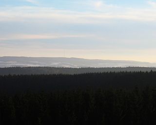
The Schwarzer Mann is a mountain in the western part of the Eifel which is known as Schnee Eifel. With a height of 697.8 meters it is the highest peak in the Schnee Eifel and third highest in the Eifel.
The Klingbach is a stream, just under 38 kilometres (24 mi) long, in South Palatinate, Germany, and a left-hand tributary of the Michelsbach.
The Roßberg near Ramberg in the county of Südliche Weinstraße in the German state of Rhineland-Palatinate is, at 637 m above sea level (NHN), the third highest mountain in the Palatine Forest.
The Kandrich, at 638.6 m above sea level (NHN), is the highest mountain in the Bingen Forest. It is near Daxweiler in the county of Bad Kreuznach in the German state of Rhineland-Palatinate.
The Riveris is an orographically right-hand, southern tributary of the River Ruwer in the German state of Rhineland-Palatinate. It was impounded in 1953 by the Riveris Dam which inter alia supplies water to the town of Trier. The name Riveris is derived from the Latin and means "little river".
The Seltenbach is a 5.3-kilometre-long (3.3 mi) stream and an orographically right-hand tributary of the Eisbach in the northeastern part of the Palatine Forest in the German state of Rhineland-Palatinate.
The Adenauer Bach is a right-hand, southern tributary of the Ahr, just under 16 kilometres long. It flows through Adenau in the county of Ahrweiler in the German state of Rhineland-Palatinate.
The Hardtkopf is a high hill in the county of Bitburg-Prüm in the German state of Rhineland-Palatinate. It rises in the South Eifel range and, at 601.5 m above sea level (NN), is the highest point on the edge of the Prüm Limestone Basin.
The Meulenwald, also called the Mühlenwald, is a bunter sandstone hill ridge, up to 448.8 m above sea level (NHN), in the southern part of the Eifel mountains in the counties of Trier-Saarburg and Bernkastel-Wittlich in the German state of Rhineland-Palatinate.
The Veitskopf is a hill, 428 m above sea level (NHN), in the Eifel mountains of Germany. It is located in the county of Ahrweiler in the state of Rhineland-Palatinate. It rises north of the lake of Laacher See in the area of the village of Wassenach.
The Enz is a 37.9-kilometre-long (23.5 mi), orographically right-hand tributary of the Prüm in the Eifel mountains of Germany.
The Odenbach is a 22.7-kilometre-long (14.1 mi) orographically right bank tributary of the Glan in the counties of Kaiserslautern and Kusel in the German state of Rhineland-Palatinate.
The Mehrbach is a river, 23-kilometre-long (14 mi) long, and a tributary of the Wied. Its GKZ is 27164, its catchment has an area of 65.868 km2 (25.432 sq mi).
The Trödelsteine is the name of a mountain, 613 m above sea level (NHN), in the Heller Upland near Emmerzhausen in the county of Altenkirchen in the German state of Rhineland-Palatinate and the county of Siegen-Wittgenstein in the state of North Rhine-Westphalia with its summit area in Rhineland-Palatinate.