
The North Downs Way National Trail is a long-distance path in southern England, opened in 1978. It runs from Farnham to Dover, past Guildford, Dorking, Merstham, Otford and Rochester, along the Surrey Hills Area of Outstanding Natural Beauty (AONB) and Kent Downs AONB.

The M2 is a 26-mile-long (42 km) long motorway in Kent, England, and was built to bypass a section of the A2 road in Kent, which goes through the Medway Towns, Sittingbourne, and Faversham. It provides an alternative route to the Port of Dover, which supplements the M20 motorway located further to the south. The terminal junctions of the M2 intersect with the A2, which come together to form a 62-mile-long (100 km) long trunk road from London to Dover.
Folkestone and Hythe is a local government district in Kent, England. It lies in the south-east of the county, on the coast of the English Channel. The district was formed in 1974 and was originally named Shepway after one of the ancient lathes of Kent, which had covered a similar area. The district was renamed in 2018. The council is based in Folkestone, the district's largest town. The district also includes the towns of Hawkinge, Hythe, Lydd and New Romney, along with numerous villages and surrounding rural areas.
The A25 road is an east–west main road in the South-East of England. Its carries traffic east from Guildford, Surrey, eastward through Surrey and into mid-west Kent, to the town of Sevenoaks, and then on to Wrotham Heath where it connects with the A20.
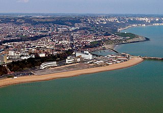
Dover is a local government district in Kent, England. It is named after its largest town, the port town of Dover. The council is based in Whitfield on the outskirts of Dover. The district also covers the towns of Deal, Sandwich and Walmer as well as the surrounding rural areas.

Drellingore is a village in South East Kent, England. It lies in the Alkham Valley, an area of outstanding natural beauty between Folkestone and Dover. Although the Alkham Valley is a dry valley most of the surrounding land forms a water catchment area. Water is extracted from the chalk aquifer for use in the Dover to Folkestone area of Kent. The population is included in the civil parish of Aylesham.

Maxton is an area in the west of Dover, in the county of Kent, England. Maxton also served as the terminus of the tramway system serving the town until its closure in 1938.

Martin is a hamlet north-east of Dover in the county of Kent in England. The nearby village of Martin Mill is situated on the railway between Dover and Deal. The population of the village is included in the civil parish of Langdon.

The Pilgrims' Way is the historical route supposedly taken by pilgrims from Winchester in Hampshire, England, to the shrine of Thomas Becket at Canterbury in Kent. This name, of comparatively recent coinage, is applied to a pre-existing ancient trackway dated by archaeological finds to 600–450 BC, but probably in existence since the Stone Age. The prehistoric route followed the "natural causeway" east to west on the southern slopes of the North Downs.

The Kent Downs is an Area of Outstanding Natural Beauty (AONB) in Kent, England. They are the eastern half of the North Downs and stretch from the London/Surrey borders to the White Cliffs of Dover, including a small section of the London Borough of Bromley. The AONB also includes the Greensand Ridge, a prominent sandstone escarpment which lies south of the chalk escarpment of the North Downs.
Cheriton Hill is a hill overlooking the English Channel near Folkestone in the south-east corner of Kent, England. The relatively low-lying hill is covered with farmland, villages, narrow lanes, and footpaths. The highest point is on a covered reservoir next to the trig point; the highest natural point is nearby, probably close to the road to the village of Paddlesworth, near a transmitter mast, but the relatively flat summit gives no real impression of being on top of a hill.

Kearsney is a village in Kent, England. At one time it would have been called a hamlet, there being no church there. The population of the village is included in the civil parish of Temple Ewell.

The Kent Downs line is a railway line between Otford and Ashford International in Kent, England. It adopted its current name in 2020, by the Kent Rail Partnership.

The Stour Valley Walk is a recreational walking route that follows the River Stour, through the Low Weald and Kent Downs, from its source at Lenham to its estuary at Pegwell Bay.

Wingmore is a small village between Canterbury and Folkestone in Kent, England. It is situated in the Elham Valley approximately halfway between the larger villages of Elham and Barham on the B2065. It consists of a few cottages and farms. The population at the 2011 Census was included in the civil parish of Elham

Brabourne Lees is a village in the civil parish of Brabourne, within the Ashford borough of Kent, England. The village (centre) is just under 5 miles (8 km) east of Ashford town centre itself geographically. By road this is a journey of about 6 miles (10 km). In 2021 it had a population of 1480.

Park Gate Down or Parkgate Down is a 7-hectare (17-acre) biological Site of Special Scientific Interest south-east of Stelling Minnis in Kent. It is also a Special Area of Conservation and is managed by the Kent Wildlife Trust,

Ashley is a hamlet located in the parish of Sutton, some five miles (8 km) north of Dover on the summit of Gaggs Hill in Kent, England. Ashley runs almost seamlessly into the neighbouring village of Studdal. The A256 road passes to the west of Ashley. The population of the hamlet is included in the civil parish of Tilmanstone.

Barnsole is a village in East Kent, England, between Canterbury and Deal. The population of the village is included in the civil parish of Wingham.

Church Whitfield is a village in the civil parish of Whitfield, and just north of Dover, in Kent, England. Village population is included in Whitfield civil parish. Part of the village is called Pineham.
