
Mindanao is the second-largest island in the Philippines, after Luzon, and seventh-most populous island in the world. Located in the southern region of the archipelago, the island is part of an island group of the same name that also includes its adjacent islands, notably the Sulu Archipelago. According to the 2020 census, Mindanao had a population of 26,252,442, while the entire island group had an estimated population of 27,021,036.

The Philippines is an archipelago that comprises 7,641 islands, and with a total land area of 300,000 square kilometers (115,831 sq mi), it is the world's fifth largest island country. The eleven largest islands contain 95% of the total land area. The largest of these islands is Luzon at about 105,000 square kilometers (40,541 sq mi). The next largest island is Mindanao at about 95,000 square kilometers (36,680 sq mi). The archipelago is around 800 kilometers (500 mi) from the Asian mainland and is located between Taiwan and Borneo.
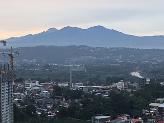
Mount Apo, also known locally as Apo Sandawa, is a large solfataric, dormant stratovolcano on the island of Mindanao, Philippines. With an elevation of 2,954 meters (9,692 ft) above sea level, it is the highest-mountain in the Philippine Archipelago, Mindanao and 24th-highest peak of an island on Earth. Located on the tripartite border of Davao City and Davao del Sur in the Davao Region, and Cotabato in Soccsksargen, Mount Apo is the most-prominent mountain in the Philippines. The peak overlooks from Davao City 45 kilometers (28 mi) to the northeast, Digos 25 kilometers (16 mi) to the southeast, and Kidapawan 20 kilometers (12 mi) to the west. It is a protected area and a Natural Park of the Philippines.
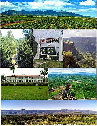
Bukidnon, officially the Province of Bukidnon, is a landlocked province in the Philippines located in the Northern Mindanao region. Its capital is the city of Malaybalay while Valencia is the largest city. The province borders, clockwise from the north, Misamis Oriental, Agusan del Sur, Davao del Norte, Cotabato, Lanao del Sur, and Lanao del Norte. According to the 2020 census, the province is inhabited by 1,541,308 residents. The province is composed of 2 component cities and 20 municipalities. It is the third largest province in the country in terms of total area of jurisdiction behind Palawan and Isabela respectively.

Agusan del Norte, officially the Province of Agusan del Norte, is a province in the Caraga region of the Philippines. Its de jure capital is the city of Cabadbaran with several government offices located in the highly-urbanized city of Butuan, which is the largest city and its de facto capital as well as the regional center of Caraga Region. It is bordered on the northwest by Butuan Bay; northeast by Surigao del Norte; mid-east by Surigao del Sur; southeast by Agusan del Sur, and southwest by Misamis Oriental.

Lanao del Sur, officially the Province of Lanao del Sur, is a province in the Philippines located in the Bangsamoro Autonomous Region in Muslim Mindanao (BARMM). The capital is the city of Marawi, and it borders Lanao del Norte to the north, Bukidnon to the east, and Maguindanao del Norte and Cotabato to the south. To the southwest lies Illana Bay, an arm of the Moro Gulf.

The Allah Valley is a large valley of the Allah River in the provinces of South Cotabato and Sultan Kudarat on the island of Mindanao, Philippines. It is formed by the Roxas-Matulas Range in the north and the Daguma Mountain Range in the south.

The Maranao people, also spelled Meranao, Maranaw, and Mëranaw, is a predominantly Muslim Filipino ethnic group native to the region around Lanao Lake in the island of Mindanao. They are known for their artwork, weaving, wood, plastic and metal crafts and epic literature, the Darangen. They are ethnically and culturally closely related to the Iranun, and Maguindanaon, all three groups being denoted as speaking Danao languages and giving name to the island of Mindanao. They are grouped with other Moro people due to their shared religion.
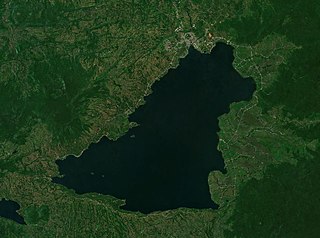
Lake Lanao is a large ancient lake in the province of Lanao del Sur, Philippines. With a surface area of 340 km2 (130 sq mi), it is the largest lake in Mindanao, the deepest and second largest lake in the Philippines, and counted as one of the 15 ancient lakes in the world. Scholars have been pushing for the lake's inclusion in the UNESCO World Heritage List. The lake's native people call themselves the Maranao or Meranaw. Their name was derived from the name of the lake, meaning "the people living around the lake".

The Rio Grande de Mindanao, also known as the Mindanao River, is the second-largest river system in the Philippines. Located on the southern island of Mindanao, with a total drainage area of 23,169 km2 (8,946 sq mi), draining the majority of the central and eastern portion of the island, and a total length of approximately 373 km (232 mi). It is an important transportation artery, used mainly in transporting agricultural products and, formerly, timber.

Valencia, officially the City of Valencia, is a 1st class component city in the province of Bukidnon, Philippines. According to the 2020 census, it has a population of 216,546 people. The city is applying for a Highly Urbanized City (HUC).
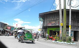
Surallah, officially the Municipality of Surallah, is a 1st class municipality in the province of South Cotabato, Philippines. According to the 2020 census, it has a population of 89,340 people.

The Lumad are a group of Austronesian indigenous peoples in the southern Philippines. It is a Cebuano term meaning "native" or "indigenous". The term is short for Katawhang Lumad, the autonym officially adopted by the delegates of the Lumad Mindanao Peoples Federation (LMPF) founding assembly on 26 June 1986 at the Guadalupe Formation Center, Balindog, Kidapawan, Cotabato. Usage of the term was accepted in Philippine jurisprudence when President Corazon Aquino signed into law Republic Act 6734, where the word was used in Art. XIII sec. 8(2) to distinguish Lumad ethnic communities from the islands of Mindanao.

The Agus River is a river that flows for 36.5 kilometres (22.7 mi) from Lake Lanao to Iligan Bay, Philippines. It cuts through the provinces of Lanao del Sur and Lanao del Norte. Settlements along the banks of the river include the city of Marawi, the municipality of Linamon, and the city of Iligan. It separates into two channels as it drains to Iligan Bay; one goes over the Maria Cristina Falls, while the other supplies the Tinago Falls. The river descends for about 2,200 feet (670 m) from its source as it flows for 21 miles (34 km) before draining to the sea. The river is relatively shallow as it is only 4 feet (1.2 m) deep in some areas. The Agus River's watershed spans about 11,320.00 hectares. It has a discharge of about 10 cubic metres per second (350 cu ft/s) and flows from a narrow depression off the northwestern rim of the lake and flows over a basalt rock formation. The canyon carved by the river suggests a short erosional period.

Mount Mélébingóy, formerly known as Parker Volcano, is an active volcano on Mindanao island in the Philippines. It is located in the province of South Cotabato, 30 km (19 mi) west of General Santos and 44 km (27 mi) south of Koronadal City.
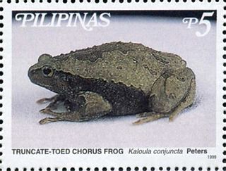
The Philippine narrowmouth toad or the truncate-toed chorus frog is a species of frog in the family Microhylidae. It is endemic to the Philippines. Its natural habitats are subtropical or tropical dry forests, subtropical or tropical moist lowland forests, subtropical or tropical moist shrubland, subtropical or tropical seasonally wet or flooded lowland grassland, rivers, intermittent rivers, freshwater lakes, intermittent freshwater lakes, freshwater marshes, intermittent freshwater marshes, arable land, pastureland, plantations, rural gardens, heavily degraded former forest, water storage areas, ponds, irrigated land, and seasonally flooded agricultural land. It is threatened by habitat loss.
The Pulangi River ;, also spelled Pulangui, is one of the major tributaries of the Rio Grande de Mindanao, an extensive river system in Mindanao, Philippines. With a length of 320 kilometres (199 mi), it is the longest river in Bukidnon and the 5th longest river in the Philippines. It traverses through majority of the cities and municipalities of Bukidnon from its source in Barangay Kalabugao, Impasugong, Bukidnon.

Lake Dapao is a deep water lake located in the province of Lanao del Sur, southwest of Lake Lanao, in the island of Mindanao in the Philippines. It is one of the deepest lakes in the country, reaching a maximum depth of 120 metres (390 ft). It has an estimated surface area of 1,011 hectares (10.11 km2). The lake receives water from local run-off and several small rivers.
The Mount Timolan Protected Landscape is a protected area covering Mount Timolan and its surrounding forested landscape in the region of Zamboanga Peninsula on Mindanao in the Philippines. The park encompasses an area of 1,994.79 hectares and a buffer zone of 695.39 hectares in the municipalities of San Miguel, Guipos and Tigbao in the province of Zamboanga del Sur. It was established on 14 August 2000 through Proclamation Order No. 354 issued by President Joseph Estrada. The park was also earlier established by the provincial government of Zamboanga del Sur as a provincial park and wildlife sanctuary known as the Zamboanga del Sur Provincial Park through Provincial Ordinance No. 3 in 1992.

The Aliwagwag Protected Landscape is a protected area that preserves a major drainage catchment in the southern Philippine island of Mindanao in the Davao Region. It contains the headwaters of the Cateel River in the southern Diuata Mountain Range which provides the water source and irrigation for surrounding rice fields and communities in Davao de Oro and Davao Oriental provinces. It was named after the remote rural village in the municipality of Cateel where Aliwagwag Falls, the country's highest waterfall, is located.

