
Labrador is a geographic and cultural region within the Canadian province of Newfoundland and Labrador. It is the primarily continental portion of the province and constitutes 71% of the province's area but is home to only 6% of its population. It is separated from the island of Newfoundland by the Strait of Belle Isle. It is the largest and northernmost geographical region in the four Atlantic provinces.

The Gulf of St. Lawrence fringes the shores of the provinces of Quebec, New Brunswick, Nova Scotia, Prince Edward Island, Newfoundland and Labrador, in Canada, plus the islands Saint-Pierre and Miquelon, possessions of France, in North America.

Ferryland is a town in Newfoundland and Labrador on the Avalon Peninsula. According to the 2021 Statistics Canada census, its population is 371.

Cape Spear is a headland located on the Avalon Peninsula of Newfoundland near St. John's in the Canadian province of Newfoundland and Labrador. At a longitude of 52°37' W, it is the easternmost point in Canada and North America, excluding Greenland.

Grand Bank or 'Grand Banc' as the first French settlers pronounced it, is a small rural town in the Canadian province of Newfoundland and Labrador, with a population of 2,580. It is located on the southern tip or "toe" of the Burin Peninsula, 360 km from the province's capital of St. John's.

Trepassey is a small fishing community located in Trepassey Bay on the south eastern corner of the Avalon Peninsula of Newfoundland and Labrador. It was in Trepassey Harbour where the flight of the Friendship took off, with Amelia Earhart on board, the first woman to fly across the Atlantic Ocean.
Hant's Harbour is an incorporated town located on the east side of Trinity Bay on the Bay de Verde Peninsula in the province of Newfoundland and Labrador, Canada. It has a population of 318 according to the 2021 Canadian census.

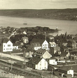
Battle Harbour is a summer fishing station, formerly a permanent settlement, located on the Labrador coast in the province of Newfoundland and Labrador, Canada. Battle Harbour was for two centuries the economic and social centre of the southeastern Labrador coast. Mercantile saltfish premises first established there in the 1770s developed into a thriving community that was known as the Capital of Labrador. It fell into decline following reductions in the cod fishery and a major fire in 1930, and was abandoned as a permanent settlement following government resettlement activity in the 1960s.
Harbour Grace is a town in Conception Bay on the Avalon Peninsula in the province of Newfoundland and Labrador, Canada. With roots dating back to the 16th century, it is one of the oldest towns in North America.
The Burin Peninsula is a peninsula located on the south coast of the island of Newfoundland in the province of Newfoundland and Labrador. Marystown is the largest population centre on the peninsula.

Carbonear Island is a small uninhabited island on the Avalon Peninsula of Newfoundland, Canada. It is located at the mouth of Carbonear harbour. It became a strategic haven for the British settlers of Carbonear fending off the raids by the French and became known for a time as the "Gibraltar of Newfoundland".
Conche is a community on the Northern Peninsula of Newfoundland and Labrador, Canada. Its population in 2021 was 149.
Woody Point is a town located in the heart of Gros Morne National Park, on the western coast of Newfoundland. Situated on Bonne Bay, the Town of Woody Point encompasses three areas: Curzon Village, Woody Point and Winterhouse Brook. It has a total population of 244 residents. Woody Point is a Registered Heritage District and has a waterfront with many heritage buildings and four Registered Newfoundland and Labrador Heritage Structures. The community is served by Route 431.
Taylor's Bay a settlement located east of Lamaline in the province of Newfoundland and Labrador. On a 1744 French map the cove was noted as Baye de Tailleur. William and Martha Bonnell, who had moved from Lamaline, are noted as the first settlers to the community.

Point May is the most southerly community on the Burin Peninsula in Newfoundland and Labrador with a population of 254 in 2021. It is a Catholic community with a church, town hall, fire hall, softball and soccer field. It is known for its close proximity, 19 km (12 mi), to the French islands of St. Pierre and Miquelon, where the smuggling of liquor and tobacco has been a way of life since before Canada was a country. The tiny Canadian Green Island lies 10 km (6 mi) west of Point May, roughly halfway to St. Pierre.
Lamaline is a town in the Canadian province of Newfoundland and Labrador. The town had a population of 480 in 1940, 643 in 1956 and 218 in the Canada 2021 Census. Lamaline was a small place with 10 families in 1864. The Way Office was established in 1863 and the first Waymaster was James Pittman.
Lord's Cove is a town in the Canadian province of Newfoundland and Labrador. The town had a population of 155 in the Canada 2021 Census. Lord's Cove has an inshore fishing history. The town is approximately 65 km southeast of Marystown.

St. Lunaire-Griquet is a town in the Canadian province of Newfoundland and Labrador. The town is located near the northern tip of the Great Northern Peninsula of Newfoundland. The town had a population of 603 in the Canada 2021 Census.
English Harbour West is a village located on the south west shore of Fortune Bay. It is noted for its bank fishing and inshore fishing. The Way Office was established in 1866 on April 1. The first Way Master was Albert Stirling. In 1891 it became a Post Office town and William Evans was the first Postmaster.
Division No. 1, Subdivision B is an unorganized subdivision on the Avalon Peninsula in Newfoundland and Labrador, Canada. It is in Division 1 and contains the unorganized communities of Iona, Little Barasway, Placentia Junction, Point Verde and Ship Harbour.


