
Payne County is a county located in the U.S. state of Oklahoma. As of the 2020 census, its population was 81,646. Its county seat is Stillwater. The county was created in 1890 as part of Oklahoma Territory and is named for Capt. David L. Payne, a leader of the "Boomers".

Cimarron County is the westernmost county in the U.S. state of Oklahoma. Its county seat is Boise City. As of the 2020 census, its population was 2,296, making it the least-populous county in Oklahoma; and indeed, throughout most of its history, it has had both the smallest population and the lowest population density of any county in Oklahoma. Located in the Oklahoma Panhandle, Cimarron County contains the only community in the state (Kenton) that observes the Mountain Time Zone. Black Mesa, the highest point in the state, is in the northwest corner of the county. The Cimarron County community of Regnier has the distinction of being the driest spot in Oklahoma ranked by lowest annual average precipitation, at just 15.62 inches; at the same time, Boise City is the snowiest location in Oklahoma ranked by highest annual average snowfall, at 31.6 inches.
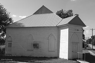
Ripley is a town in southeastern Payne County, Oklahoma, United States. The population was 423 at the 2010 census, a decline of 9.2 percent from the figure of 444 in 2000. The town was named after Edward Ripley, the 14th president of the Atchison, Topeka and Santa Fe Railway.

Purcell is a city in and the county seat of McClain County, Oklahoma, United States. As of the 2020 census, the city population was 6,651, a 13% increase from 2010.

The Cimarron River extends 698 miles (1,123 km) across New Mexico, Oklahoma, Colorado, and Kansas. The headwaters flow from Johnson Mesa west of Folsom in northeastern New Mexico. Much of the river's length lies in Oklahoma, where it either borders or passes through eleven counties. There are no major cities along its route. The river enters the Oklahoma Panhandle near Kenton, Oklahoma, crosses the corner of southeastern Colorado into Kansas, reenters the Oklahoma Panhandle, reenters Kansas, and finally returns to Oklahoma where it joins the Arkansas River at Keystone Reservoir west of Tulsa, Oklahoma, its only impoundment. The Cimarron drains a basin that encompasses about 18,927 square miles (49,020 km2).

State Highway 99 (SH-99) is a north–south state highway through central Oklahoma. It runs from the Texas state line at Lake Texoma to the Kansas state line near Lake Hulah. It is 241.5 miles (388.7 km) long. The highway overlaps U.S. Highway 377 (US-377) for over half its length.
James Allen Williamson is an American attorney and Republican politician from the U.S. state of Oklahoma. Williamson served in the Oklahoma House of Representatives from 1980 to 1986 and in the Oklahoma Senate from 1996 to 2008. From 1998 to 2002 he served as Assistant Republican Floor Leader, and then as Floor Leader from 2003 to 2004.

State Highway 325, officially, SH-325, is a 38.08-mile (61.28 km)state highway Cimarron County, Oklahoma, United States, that connects New Mexico State Road 456 to the traffic circle in Boise City that includes U.S. Route 56, U.S. Route 64, U.S. Route 287, U.S. Route 287, U.S. Route 412 and Oklahoma State Highway 3. Along the way it provides access to Black Mesa State Park, near Black Mesa, the highest point in the state of Oklahoma.

State Highway 171, abbreviated as SH-171, is a state highway in Cimarron County, Oklahoma, in the Oklahoma Panhandle. It runs for 21.47 miles (34.55 km) north and south through the eastern part of the county, connecting U.S. Highway 287 near the Oklahoma-Texas state line to US-56 in Keyes. The only other highway it intersects with is US-64/412/SH-3, three miles (5 km) south of Keyes. SH-171 has no lettered spur routes.

State Highway 50 is a state highway in northwestern Oklahoma. The majority of the 37.7-mile (60.7 km) highway is in Woodward County, though the northernmost three miles (4.8 km) are in Woods County. SH-50 runs near two state parks and has a lettered spur that goes to each of them.

State Highway 108 is a minor state highway in Payne, Noble, and Pawnee counties in north-central Oklahoma. It runs for 24.1 miles (38.8 km), from SH-33 south of Ripley to U.S. Route 64 (US-64) in Lela. It has no lettered spurs.
Allen Williamson is a former Oklahoma politician who served in the Oklahoma House of Representatives from 1966 to 1974. He is related to James Allen Williamson, an Oklahoma State Senator elected in 1996.

State Highway 34 is a state highway in the U.S. state of Oklahoma. It runs for 188.3 miles (303.0 km) south-to-north in the western part of the state. The highway begins northeast of Eldorado, in the southwest corner of the state, and extends north to the Kansas state line between Woodward and Coldwater, Kansas.

State Highway 48 is a state highway in eastern Oklahoma that runs nearly 159.1 miles (256.0 km) from Bryan County to Pawnee County. SH-48 has one lettered spur, SH-48A, in Johnston County.
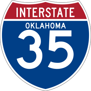
Interstate 35 (I-35), in the US State of Oklahoma, runs from the Red River at the Texas border to the Kansas state line near Braman for a length of 236 miles (380 km). I-35 has one auxiliary route in the state, I-235, in the inner city of Oklahoma City. A second auxiliary route, I-335, is the designation for the Kickapoo Turnpike, although it will not meet I-35 until the southern extension of the turnpike to a junction with I-35 in Purcell is built. Excluding the Panhandle, I-35 forms the informal bisector for central Oklahoma, and along with US 81/US 283 in western Oklahoma and US 69/US 75 in the eastern portion, it provides one of the main north-south corridors through the state.
The US 77 James C. Nance Memorial Bridge connecting Purcell and Lexington was originally built as a circa 1938 deck truss two-lane bridge and in 2019 rebuilt as a concrete pier four-lane bridge crossing the Canadian River and the BNSF Railway between Purcell and Lexington, Oklahoma. The bridge designated on the list of state highways in Oklahoma carries U.S. Route 77 (US-77) and Oklahoma State Highway 39 (SH-39) from McClain County to Cleveland County. The bridge is named for James C. Nance, longtime community newspaper chain publisher and Speaker of the Oklahoma House of Representatives, President pro tempore of the Oklahoma Senate and member of U.S Uniform Law Commission.

U.S. Route 60 (US-60) is a transcontinental U.S. highway extending from near Brenda, Arizona to Virginia Beach, Virginia on the Atlantic Ocean. Along the way, 352.39 miles (567.12 km) of the route lies within the state of Oklahoma. The highway crosses into the state from Texas west of Arnett and serves many towns and cities in the northern part of the state, including Arnett, Seiling, Fairview, Enid, Ponca City, Pawhuska, Bartlesville, and Vinita. US-60 exits Oklahoma near Seneca, Missouri. In Oklahoma, US-60 has three business routes, serving Tonkawa, Ponca City, and Seneca. The first 60.2 miles (96.9 km) of the route, from the Texas line to Seiling, is also designated as State Highway 51 (SH-51).

U.S. Route 412 is a U.S. highway in the south-central portion of the United States, connecting Springer, New Mexico to Columbia, Tennessee. A 504.11-mile (811.29 km) section of the highway crosses the state of Oklahoma, traversing the state from west to east. Entering the state southwest of Boise City, US-412 runs the length of the Oklahoma Panhandle and serves the northern portion of the state's main body, before leaving the state at West Siloam Springs. Along the way, the route serves many notable cities and towns, including Boise City, Guymon, Woodward, Enid, and the state's second-largest city, Tulsa.

U.S. Route 64 (US-64) is a U.S. highway running from the Four Corners area to the Outer Banks of North Carolina. Between these two points, the highway passes through the entire width of Oklahoma; a total of 591.17 miles (951.40 km) of US-64 lies in the state of Oklahoma. US-64 enters the state from New Mexico, crossing the line between the two states between Clayton, New Mexico, and Boise City in Cimarron County. The route runs the full length of the Oklahoma Panhandle, then serves the northernmost tier of counties in the main body of the state before dipping southeastward to Tulsa, the state's second-largest city. From Tulsa, the highway continues southeast, leaving Oklahoma just west of Fort Smith, Arkansas. In addition to Tulsa, US-64 serves fifteen Oklahoma counties and the cities of Guymon, Woodward, Enid, and Muskogee.

K-23 is a 199.117-mile-long (320.448 km) south–north state highway in the U.S. State of Kansas. It starts as a continuation of Oklahoma State Highway 23 (SH-23) and it runs northward to U.S. Route 83 (US-83) and K-383 near Selden. Along the way it intersects several major east–west highways, including US-54 and US-160 in Meade, US-50 and US-400 in Cimarron, US-56 near Montezuma, K-4 near Healy, and Interstate 70 (I-70) and US-40 south of Grainfield. All but about 1.5 miles (2.4 km) of K-23's alignment is maintained by the Kansas Department of Transportation. The entire section within Cimarron is maintained by the city and a section in Hoxie from Utah Street to Queen Street is maintained by the city.
