Alpine Dam
Alpine Dam (national ID number: CA00204) is a gravity dam which was completed in 1917(106 years ago) (1917). It is 524 feet (160 m) long and 143 feet (44 m) high, with 8 feet (2.4 m) of freeboard. [2]
In 1912, the Marin Municipal Water District, serving San Rafael, the Ross Valley and all of southern Marin, was the first municipal water district to be created in California. One of district's first tasks was to build Alpine Dam to provide drinking water for the county's growing population. [5]
The dam was designed with consultation provided by Michael O’Shaughnessy, who was, at the time, a board member of the district. Construction on Alpine started in the summer of 1917, but the outbreak of World War I led to shortages of labor and materials for the contractor. [5]
In January 1918 district took over the building of Alpine Dam and construction was completed a year later. When first built, the reservoir held just over a billion gallons of water, but the dam was raised in 1924 and again in 1941. The reservoir now has a capacity approaching 3 billion gallons and continues to play a vital role in supplying fresh water to thousands of people in the district. [5]

Diamond Valley Lake is a man-made off-stream reservoir located near Hemet, California, United States. It is one of the largest reservoirs in Southern California and one of the newest. It has a capacity of 800,000 acre-feet (990,000,000 m3). The lake nearly doubled the area's surface water storage capacity and provides additional water supplies for drought, peak summer, and emergency needs.

The Metropolitan Water District of Southern California is a regional wholesaler and the largest supplier of treated water in the United States. The name is usually shortened to "Met," "Metropolitan," or "MWD." It is a cooperative of fourteen cities, eleven municipal water districts, and one county water authority, that provides water to 19 million people in a 5,200-square-mile (13,000 km2) service area. It was created by an act of the California State Legislature in 1928, primarily to build and operate the Colorado River Aqueduct. Metropolitan became the first contractor to the State Water Project in 1960.

San Luis Dam is a major earth-filled dam in Merced County, California, which forms San Luis Reservoir, the largest off-stream reservoir in the United States. The dam and reservoir are located in the Diablo Range to the east of Pacheco Pass and about 10 miles (16 km) west of Los Banos. San Luis Dam, a jointly-owned state and federal facility, stores more than 2 million acre feet (2.5 km3) of water for the California State Water Project and the federal Central Valley Project. Although the dam is located in the valley of San Luis Creek, the majority of its water comes from man-made aqueducts which are supplied from other rivers in Northern California.

Lake Murray is a reservoir in San Diego, California, operated by the City of San Diego's Public Utilities Department. Although thinly divided by a few housing communities and select roadways, it is technically considered to be part of the jurisdiction which makes up Mission Trails Regional Park. When full, the reservoir covers 171.1 acres (69.2 ha), has a maximum water depth of 95 feet (29 m), and a shoreline of 3.2 miles (5.1 km). The asphalt-paved service road lining roughly two-thirds of the lake's perimeter is a popular recreation site for the Navajo community as well as residents of the northernmost neighborhoods in La Mesa. It lies south of Cowles Mountain and a small golf course. It also functions as an important aeronautical reporting point for aircraft inbound to land at Montgomery-Gibbs Executive Airport.

Spruce Run Recreation Area is a 1,290-acre (5.2 km2) New Jersey state recreation area located in Union Township and Clinton Township in Hunterdon County, New Jersey, United States. It encompasses the Spruce Run Reservoir that is used as a backup reservoir to protect the state from prolonged droughts. The reservoir is the third largest in the state, after Round Valley and Wanaque Reservoir. The reservoir is used for recreation purposes, including hunting, fishing, boating and swimming.

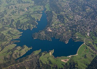
The San Pablo Reservoir is an open cut terminal water storage reservoir owned and operated by the East Bay Municipal Utility District (EBMUD). It is located in the valley of San Pablo Creek, north of Orinda, California, United States, and south of El Sobrante and Richmond, east of the Berkeley Hills between San Pablo Ridge and Sobrante Ridge.
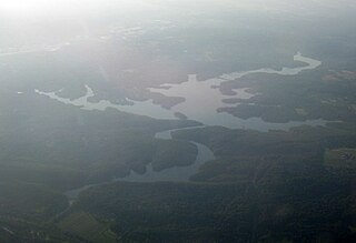
Briones Reservoir is an open cut terminal water storage reservoir located in western Contra Costa County, in the East Bay region of the San Francisco Bay Area, California.
Kent Lake is a reservoir in western Marin County, California formed by the construction of Peters Dam across Lagunitas Creek. Built in 1954, the lake is the most recent lake of the Marin Municipal Water District, as well as the largest. It lies to the west of Alpine Lake; among the five major lakes in the area it is the only one to the west of Fairfax-Bolinas Road.
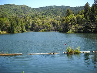
Lake Lagunitas is a reservoir on Lagunitas Creek in Marin County, California.
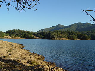
Bon Tempe Lake is a reservoir in Marin County, California, managed by the Marin Municipal Water District. It is the widest lake in the Mount Tamalpais watershed, and on Lagunitas Creek. Beneath its dam is Alpine Lake. Lake Lagunitas is immediately to its east.

Lexington Reservoir is an artificial lake on the Los Gatos Creek near Los Gatos, California. The James J. Lenihan Dam, a 195 ft (59 m) high, 1,000 ft (300 m) thick earthen dam, forms the third-largest reservoir in Santa Clara County.
The Central Utah Project is a US federal water project that was authorized for construction under the Colorado River Storage Project Act of April 11, 1956, as a participating project. In general, the Central Utah Project develops a portion of Utah's share of the yield of the Colorado River, as set out in the Colorado River Compact of 1922.

The Los Vaqueros Reservoir and watershed is located in the northern Diablo Range, within northeastern Contra Costa County, northern California. It was completed by the Contra Costa Water District (CCWD) in 1998 to improve the quality of drinking water for its 550,000 customers in Central and Eastern Contra Costa County. The reservoir is accessible via Vasco Road, a road which connects Brentwood and Livermore.
The Loch Raven Reservoir is a reservoir that provides drinking water for the City of Baltimore and most of Baltimore County, Maryland. It is fed by the Big Gunpowder Falls river, and has a capacity of 23 billion US gallons (87,000,000 m3) of water.

The Lafayette Reservoir is an open-cut human-made terminal water storage reservoir owned and operated by the East Bay Municipal Utility District (EBMUD). Completed in 1933, it was intended solely as a standby water supply for EBMUD customers. EBMUD opened the reservoir for public recreation in 1966. It is located off of California State Route 24 and a mile from the Lafayette BART station, in Contra Costa County, California, United States. This all-year, day-use area is ideal for hiking, jogging, fishing, boating and picnicking. The reservoir is on the Lafayette-Orinda border. The reservoir is on a 925-acre (3.74 km2) site and holds 1.4 billion US gallons (5,300,000 m3)

Anderson Lake, also known as Anderson Reservoir, is an artificial lake in Morgan Hill, located in southern Santa Clara County, California. The reservoir is formed by the damming of Coyote Creek just below its confluence with Las Animas Creek. A 4,275-acre (1,730 ha) county park surrounds the reservoir and provides limited fishing, picnicking, and hiking activities. Although swimming is prohibited, boating, water-skiing, and jet-skiing are permitted in the reservoir.

Lake Hodges is a lake and reservoir located within the city limits of San Diego, California. It is about 31 miles (50 km) north of Downtown San Diego, just north of the Rancho Bernardo community, and just south of the city's border with Escondido. When full, the reservoir has 1,234 acres (4.99 km2), a maximum water depth of 115 feet (35 m), and 27 miles (43 km) of shoreline. Lake Hodges has a total capacity of 30,251 acre-feet of water. Lake Hodges is owned by the city of San Diego, supplies water to the San Dieguito Water District and Santa Fe Irrigation District, and its mailing city address is Escondido.
The Marin Municipal Water District is the government agency that provides drinking water to southern and central Marin County, California. Chartered in 1912, it became California's first municipal water district. It serves 191,000 customers in a 147-square-mile (380 km2) area that includes ten towns and cities.

Camanche Dam is an earthfill Dam on the Mokelumne River in the central California, about 20 mi (32 km) from East Lodi. The dam and reservoir lie in the Sierra Nevada foothills in San Joaquin County. Construction of Camanche Dam was started in 1963 and completed in 1964. East Bay Municipal Utilities District (EBMUD) owns and operates it. The purpose of Camanche Dam and reservoir is to provide flood control, water flows for agriculture, habitat for fisheries and recreation for community.

Upper San Leandro Reservoir is an artificial lake in Alameda County and Contra Costa County, California which provides water for the East Bay Municipal Utility District (EBMUD). It is impounded by the earth-filled San Leandro Dam on San Leandro Creek, located at the southeast end of the lake.


