
The Pennines, also known as the Pennine Chain or Pennine Hills, are a range of uplands mainly located in Northern England. Commonly described as the "backbone of England" because of its length and position, the range runs from the north Midlands to North East England, near the Anglo-Scottish border. The Peak District is the southern end of the range, rising northwards from its foothills near the Trent Valley in northern Staffordshire, and further north into eastern Cheshire and southern Derbyshire. Beyond this are the South Pennines, Yorkshire Dales, and North Pennines, ending at the Tyne Gap. Beyond the gap are the Border Moors and Cheviot Hills, which are included in some definitions of the range.

The North Pennines is the northernmost section of the Pennine range of hills which runs north–south through northern England. It lies between Carlisle to the west and Darlington to the east. It is bounded to the north by the Tyne Valley and to the south by the Stainmore Gap.
The geology of Shropshire is very diverse with a large number of periods being represented at outcrop. The bedrock consists principally of sedimentary rocks of Palaeozoic and Mesozoic age, surrounding restricted areas of Precambrian metasedimentary and metavolcanic rocks. The county hosts in its Quaternary deposits and landforms, a significant record of recent glaciation. The exploitation of the Coal Measures and other Carboniferous age strata in the Ironbridge area made it one of the birthplaces of the Industrial Revolution. There is also a large amount of mineral wealth in the county, including lead and baryte. Quarrying is still active, with limestone for cement manufacture and concrete aggregate, sandstone, greywacke and dolerite for road aggregate, and sand and gravel for aggregate and drainage filters. Groundwater is an equally important economic resource.

Millstone Grit is the name given to any of a number of coarse-grained sandstones of Carboniferous age which occur in the British Isles. The name derives from its use in earlier times as a source of millstones for use principally in watermills. Geologists refer to the whole suite of rocks that encompass the individual limestone beds and the intervening mudstones as the Millstone Grit Group. The term Millstone Grit Series was formerly used to refer to the rocks now included within the Millstone Grit Group together with the underlying Edale Shale Group.

The Geology of Yorkshire in northern England shows a very close relationship between the major topographical areas and the geological period in which their rocks were formed. The rocks of the Pennine chain of hills in the west are of Carboniferous origin whilst those of the central vale are Permo-Triassic. The North York Moors in the north-east of the county are Jurassic in age while the Yorkshire Wolds to the south east are Cretaceous chalk uplands. The plain of Holderness and the Humberhead levels both owe their present form to the Quaternary ice ages. The strata become gradually younger from west to east.

Stainmore is a remote geographic area in the Pennines on the border of Cumbria, County Durham and North Yorkshire. The name is used for a civil parish in the Eden District of Cumbria, England, including the villages of North Stainmore and South Stainmore. The parish had a population of 253 in the 2001 census, increasing to 264 at the Census 2011. Stainmore Forest stretches further east into County Durham, towards Bowes.

The Craven Fault System is the name applied by geologists to the group of crustal faults in the Pennines that form the southern edge of the Askrigg Block and which partly bounds the Craven Basin. Sections of the system's component faults which include the North, Middle and South Craven faults and the Feizor Fault are evident at the surface in the form of degraded faults scarps where Carboniferous Limestone abuts millstone grit. The fault system is approximately coincident with the southwestern edge of the Yorkshire Dales National Park and the northeastern edge of the Bowland Fells.
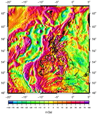
Variations in the strength of gravity occur from place to place according to the density distribution of the rocks beneath the surface. Such gravity anomalies have been mapped across the British Isles and adjacent areas and they reveal aspects of these islands’ geological structure.
The geological structure of Great Britain is complex, resulting as it does from a long and varied geological history spanning more than two billion years. This piece of the Earth's crust has experienced several episodes of mountain building or 'orogenies', each of which has added further complexity to the picture.
The Askrigg Block is the name applied by geologists to the crustal block forming a part of the Pennines of northern England and which is essentially coincident with the Yorkshire Dales. It is defined by the Dent Fault to the west and the Craven Fault System to the south whilst to the north it is separated from the Alston Block by the Stainmore Trough. It originated as a geological structure during the Carboniferous Period as a major element in the Pennine Block & Basin Province.

West Rigg Open Cutting is a Site of Special Scientific Interest in the Wear Valley district of west County Durham, England. It is a disused ironstone quarry, located just over 1 km north of the village of Westgate, in Weardale.

The Dent Fault is a major fault zone on the boundary between the counties of Cumbria and North Yorkshire in northern England. It is named after the village of Dent in Dentdale, on the western margin of the Yorkshire Dales.
The geology of Lancashire in northwest England consists in the main of Carboniferous age rocks but with Triassic sandstones and mudstones at or near the surface of the lowlands bordering the Irish Sea though these are largely obscured by Quaternary deposits.
The geology of Merseyside in northwest England largely consists of a faulted sequence of Carboniferous Coal Measures rocks overlain in the west by younger Triassic and Permian age sandstones and mudstones. Glaciation during the present Quaternary Period has left widespread glacial till as well as erosional landforms. Other post-glacial superficial deposits such as river and estuarine alluvium, peat and blown sand are abundant.
The geology of County Durham in northeast England consists of a basement of Lower Palaeozoic rocks overlain by a varying thickness of Carboniferous and Permo-Triassic sedimentary rocks which dip generally eastwards towards the North Sea. These have been intruded by a pluton, sills and dykes at various times from the Devonian Period to the Palaeogene. The whole is overlain by a suite of unconsolidated deposits of Quaternary age arising from glaciation and from other processes operating during the post-glacial period to the present. The geological interest of the west of the county was recognised by the designation in 2003 of the North Pennines Area of Outstanding Natural Beauty as a European Geopark.
The Great Scar Limestone Group is a lithostratigraphical term referring to a succession of generally fossiliferous rock strata which occur in the Pennines in northern England and in the Isle of Man within the Tournaisian and Visean stages of the Carboniferous Period.
The geology of Northumberland in northeast England includes a mix of sedimentary, intrusive and extrusive igneous rocks from the Palaeozoic and Cenozoic eras. Devonian age volcanic rocks and a granite pluton form the Cheviot massif. The geology of the rest of the county is characterised largely by a thick sequence of sedimentary rocks of Carboniferous age. These are intruded by both Permian and Palaeogene dykes and sills and the whole is overlain by unconsolidated sediments from the last ice age and the post-glacial period. The Whin Sill makes a significant impact on Northumberland's character and the former working of the Northumberland Coalfield significantly influenced the development of the county's economy. The county's geology contributes to a series of significant landscape features around which the Northumberland National Park was designated.
The Northumberland Trough, also known as the Northumberland Basin, is an element of the structural geology of northern England, the origin of which dates back to the Carboniferous period when a block and basin province was established throughout the Pennine region.
The geology of the Yorkshire Dales National Park in northern England largely consists of a sequence of sedimentary rocks of Ordovician to Permian age. The core area of the Yorkshire Dales is formed from a layer-cake of limestones, sandstones and mudstones laid down during the Carboniferous period. It is noted for its karst landscape which includes extensive areas of limestone pavement and large numbers of caves including Britain's longest cave network.
