Alte Oder

Last updated

Alte Oder
Neutornow-57.jpg
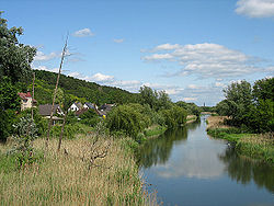
Alte Oder near Bad Freienwalde
Brandenburg relief location map.jpg
Red pog.svg
Location of mouth in Brandenbur
Location
Country Germany
State Brandenburg
Physical characteristics
Mouth  
  location
Oder
  coordinates
52°52′51″N14°09′26″E / 52.8807°N 14.1571°E / 52.8807; 14.1571 Coordinates: 52°52′51″N14°09′26″E / 52.8807°N 14.1571°E / 52.8807; 14.1571

The name Alte Oder may refer to several old branches of the Oder River. The most important one is in Brandenburg, Germany, where it drains the Oderbruch basin, flowing northwards to the confluence with the Oder near Hohensaaten.

See also


Related Research Articles

Brandenburg State in Germany

Brandenburg is a state in the northeast of Germany. With an area of 29,478 square kilometres (11,382 sq mi) and a population of 2.5 million residents, it is the fifth-largest German state by area and the tenth-most populous. Potsdam is the state capital and largest city, while other major towns include Cottbus, Brandenburg an der Havel and Frankfurt (Oder).

Frankfurt (Oder) Town in Brandenburg, Germany

Frankfurt (Oder) is a town in Brandenburg, Germany, located on the west side of the Oder River, on the Germany-Poland border, about 80 kilometres (50 mi) east of Berlin.

Havel River in Germany

The Havel is a river in northeastern Germany, flowing through the states of Mecklenburg-Vorpommern, Brandenburg, Berlin and Saxony-Anhalt. It is a right tributary of the Elbe and 325 kilometres (202 mi) long. However, the direct distance from its source to its mouth is only 94 kilometres (58 mi). For much of its length, the Havel is navigable; it provides an important link in the waterway connections between the east and west of Germany, as well as beyond.

Uckermark is a Kreis (district) in the northeastern part of Brandenburg, Germany. Neighboring districts are Barnim and Oberhavel, the districts Mecklenburgische Seenplatte and Vorpommern-Greifswald in Mecklenburg-Vorpommern, and to the east Poland. It is one of the largest districts of Germany areawise. The district is named after the historical region of Uckermark.

Barnim is a district in Brandenburg, Germany. It is bounded by Poland, the district of Märkisch-Oderland, the city state of Berlin and the districts of Oberhavel and Uckermark.

Märkisch-Oderland is a Landkreis (district) in the eastern part of Brandenburg, Germany. Neighboring are the district Barnim, the country Poland, the district-free city Frankfurt (Oder), the district Oder-Spree and the Bundesland Berlin. The administrative seat is Seelow but the largest town is Strausberg.

Oder-Spree is a Kreis (district) in the eastern part of Brandenburg, Germany. Neighboring are the district Märkisch-Oderland, the district-free city Frankfurt (Oder), Poland, the districts Spree-Neiße and Dahme-Spreewald, and the Bundesland Berlin.

Neumark

The Neumark, also known as the New March or as East Brandenburg, was a region of the Margraviate of Brandenburg and its successors located east of the Oder River in territory which became part of Poland in 1945.

Schwedt Place in Brandenburg, Germany

Schwedt is a town in northeastern Brandenburg, Germany. With the official status of a Große kreisangehörige Stadt, it is the largest town of the Uckermark district, located near the river Oder, which forms the border with modern-day Poland.

Gartz Place in Brandenburg, Germany

Gartz is a town in the Uckermark district in Brandenburg, Germany. It is located on the West bank of the Oder River, on the border with Poland, about 20 km south of Szczecin, Poland. It is located within the historic region of Pomerania.

Lower Lusatia Geographic region in Europe

Lower Lusatia is a historical region in Central Europe, stretching from the southeast of the German state of Brandenburg to the southwest of Lubusz Voivodeship in Poland. Like adjacent Upper Lusatia in the south, Lower Lusatia is a settlement area of the West Slavic Sorbs whose endangered Lower Sorbian language is related to Upper Sorbian and Polish.

Lebus Place in Brandenburg, Germany

Lebus is a historic town in the Märkisch-Oderland District of Brandenburg, Germany. It is the administrative seat of Amt Lebus. The town, located on the west bank of the Oder river at the border with Poland, was the centre of the historical region known as Lubusz Land, which provides the name for the present-day Polish Lubusz Voivodeship.

Fürstenwalde Place in Brandenburg, Germany

Fürstenwalde/Spree is the most populous town in the Oder-Spree District of Brandenburg, Germany.

Kostrzyn nad Odrą Place in Lubusz Voivodeship, Poland

Kostrzyn nad Odrą is a town in Gorzów County, Lubusz Voivodeship in western Poland, close to the border with Germany.

Province of Brandenburg

The Province of Brandenburg was a province of Prussia from 1815 to 1945. Brandenburg was established in 1815 from the Kingdom of Prussia's core territory, comprised the bulk of the historic Margraviate of Brandenburg and the Lower Lusatia region, and became part of the German Empire in 1871. From 1918, Brandenburg was a province of the Free State of Prussia until it was dissolved in 1945 after World War II, and replaced with reduced territory as the State of Brandenburg in East Germany, which was later dissolved in 1952. Following the reunification of Germany in 1990, Brandenburg was re-established as a federal state of Germany, becoming one of the new states.

Margraviate of Brandenburg Major principality of the Holy Roman Empire from 1157 to 1806

The Margraviate of Brandenburg was a major principality of the Holy Roman Empire from 1157 to 1806 that played a pivotal role in the history of Germany and Central Europe.

Neißemünde Place in Brandenburg, Germany

Neißemünde is a municipality in the Oder-Spree district, in Brandenburg, Germany. It belongs to the Amt Neuzelle, which has its administrative seat in the neighbouring Neuzelle municipality.

The Uckermark is a historical region in northeastern Germany, currently straddles the Uckermark District of Brandenburg and the Vorpommern-Greifswald District of Mecklenburg-Vorpommern. Its traditional capital is Prenzlau.

Treaty of Stettin (1653) 1653 treaty between Brandenburg and Sweden

The Treaty of Stettin of 4 May 1653 settled a dispute between Brandenburg and Sweden, who both claimed succession in the Duchy of Pomerania after the extinction of the local House of Pomerania during the Thirty Years' War. Brandenburg's claims were based on the Treaty of Grimnitz (1529), while Sweden's claims were based on the Treaty of Stettin (1630). The parties had agreed on a partition of the Swedish-held duchy in the Peace of Westphalia (1648), and with the Treaty of Stettin determined the actual border between the partitions. Western Pomerania became Swedish Pomerania, Farther Pomerania became Brandenburgian Pomerania.

Eisenhüttenstadt Town in Germany

Eisenhüttenstadt is a town in the Oder-Spree district of the state of Brandenburg, Germany, on the border with Poland. It was known as Stalinstadt (Stalinměsto) when East Germany founded the city in 1950.