Alter Stolberg

Last updated
Alter Stolberg

Stempeda.jpg

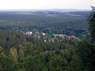
Stempeda at the foot of the Alter Stolberg
Highest point
Peak Königskopf
Elevation 357.7 m above NN
Geography
Country Germany
Range coordinates 51°31′36″N10°54′31″E / 51.52667°N 10.90861°E / 51.52667; 10.90861 Coordinates: 51°31′36″N10°54′31″E / 51.52667°N 10.90861°E / 51.52667; 10.90861
Parent range South Harz Zechstein Belt, Thuringian Basin

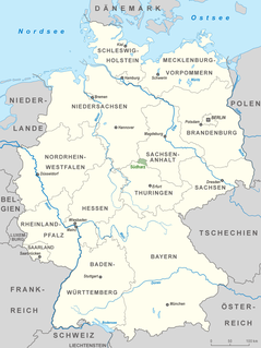
The Alter Stolberg is a wooded karst plateau, up to 357.7 m above  sea level (NN) , in the South Harz in Central Germany. It lies in the districts of Nordhausen in the state of Thuringia and Mansfeld-Südharz in the state of Saxony-Anhalt.

Karst Topography formed from the dissolution of soluble rocks

Karst is a topography formed from the dissolution of soluble rocks such as limestone, dolomite, and gypsum. It is characterized by underground drainage systems with sinkholes and caves. It has also been documented for more weathering-resistant rocks, such as quartzite, given the right conditions. Subterranean drainage may limit surface water, with few to no rivers or lakes. However, in regions where the dissolved bedrock is covered or confined by one or more superimposed non-soluble rock strata, distinctive karst features may occur only at subsurface levels and be totally missing above ground.

Normalnull

Normalnull or Normal-Null is an outdated official vertical datum used in Germany. Elevations using this reference system were to be marked "Meter über Normal-Null". Normalnull has been replaced by Normalhöhennull.

Thuringia State in Germany

Thuringia, officially the Free State of Thuringia, is a state of Germany.

Contents

Geographical location

The ridge of the Alter Stolberg is part of the South Harz Zechstein belt and lies mainly in Thuringia; with its eastern foothills dropping into the valley of the Krebsbach stream and Thyra river. To the north is the Harz; to the south the Goldene Aue through which the River Helme flows.

The Zechstein is a unit of sedimentary rock layers of Middle to Late Permian age located in the European Permian Basin which stretches from the east coast of England to northern Poland. The name Zechstein was formerly also used as a unit of time in the geologic timescale, but nowadays it is only used for the corresponding sedimentary deposits in Europe.

Thyra (river) river in Germany

The Thyra is a 20-kilometre (12 mi) long river in the district of Mansfeld-Südharz in the Harz Mountains of central Germany.

The Goldene Aue is a valley in eastern Germany, in the states Thuringia and Saxony-Anhalt. It is situated between the towns Nordhausen in the west, and Sangerhausen in the east. It is bordered by the mountain ranges Harz in the north, and Windleite and Kyffhäuser in the south. The river Helme flows through the Goldene Aue.

The Alter Stolberg lies between the following parishes in clockwise order: Görsbach and Urbach to the south, Leimbach and Steigerthal to the west, Buchholz and Herrmannsacker to northwest, Stempeda and − on the other sides of that − Rodishain to the north (all in Thuringia) and the Saxony-Anhalt villages of Rottleberode and Uftrungen to the east.

Görsbach Place in Thuringia, Germany

Görsbach is a municipality in the district of Nordhausen, in Thuringia, Germany.

Herrmannsacker Ortsteil of Harztor in Thuringia, Germany

Herrmannsacker is a village and a former municipality in the district of Nordhausen, in Thuringia, Germany. Since July 2018, it is part of the municipality Harztor.

Stempeda Village of Nordhausen in Thuringia, Germany

Stempeda is a former municipality in the district of Nordhausen, in Thuringia, Germany. Since 1 December 2007, it is part of the town Nordhausen.

The highest hill in the Alter Stolberg is the Königskopf (357.7 m above  sea level (NN) ) which rises in the northern part of the ridge. Another prominent hill is the Reesberg (325.2 m above NN) in the southeastern part.

Points of interest

The northern part of the heavily forested ridge is designated as the Alter Stolberg Nature Reserve and large parts of it as the Alter Stolberg Protected Landscape.

Near the Reesberg is the plaster cave, known as Heimkehle. In addition, the ridge is home to the ruins of the Grasburg, a medieval refuge castle, which legend has it was the family castle of the Counts of Stolberg. [1]

Grasburg (Rottleberode) castle

The Grasburg is a prehistoric refuge castle, in the form of a hillfort with a rampart and ditch system, near Rottleberode in the district of Mansfeld-Südharz in the German state of Saxony-Anhalt.

Related Research Articles

Wernigerode Place in Saxony-Anhalt, Germany

Wernigerode is a town in the district of Harz, Saxony-Anhalt, Germany. Until 2007, it was the capital of the district of Wernigerode. Its population was 35,041 in 2012.

Benneckenstein Stadtteil of Oberharz am Brocken in Saxony-Anhalt, Germany

Benneckenstein is a town in the district of Harz, in Saxony-Anhalt, Germany. Since 1 January 2010, it has been part of the town of Oberharz am Brocken. Benneckenstein is in the eastern Harz, 14 km southeast of Braunlage, and 24 km south of Wernigerode.

The Finne is a ridge of hills in the German states of Saxony-Anhalt and Thuringia up to 370.1 m above sea level (NHN) and 23 km long.

Hohnekamm mountain

The Hohnekamm or Hohne Kamm is a mountain ridge up to 900 m above sea level high in the Harz mountains of central Germany. It is located in the state of Saxony-Anhalt, and is well known for its rock towers or tors, the Hohneklippen.

Butterberg (Ilsenburg) mountain in the Harz, Germany

The Butterberg is a hill, about 280 m above sea level (NN) high, in the county of Harz in the German state of Saxony-Anhalt.

Scharfenstein (Ilsenburg) mountain

The Scharfenstein is a mountain, 697.6 m above sea level (NN) high, in the Harz Mountains of Germany, near Ilsenburg in the district of Harz in Saxony-Anhalt. It is part of the Harz National Park.

The Ahrensklint or Ahrentsklint in the Harz Mountains is a granite rock formation, 822.4 m above sea level (NN), on the Erdbeerkopf in Harz district in the German state of Saxony-Anhalt.

Austberg mountain in the Harz, Germany

The Austberg, also called the Augsberg or Augstberg, is a low hill, 292 m above sea level (NN), in the northern Harz Foreland near the village of Benzingerode in the district of Harz in the German state of Saxony-Anhalt.

Ackeburg castle

The Ackeburg, also called the Ackenburg, in the Harz Mountains of central Germany, is the site of a high medieval hill castle, 333.2 m above sea level (NN), in the borough of Falkenstein/Harz in Harz district in the state of Saxony-Anhalt. It was first mentioned in 1216 and was abandoned or destroyed in 1400. There was also a village associated with it, known as Akkeburg.

Meisdorf Ortsteil of Falkenstein/Harz in Saxony-Anhalt, Germany

Meisdorf is a village in the town of Falkenstein/Harz in the district of Harz in the German state of Saxony-Anhalt.

Old Falkenstein Castle castle

Old Falkenstein Castle in the Harz Mountains of Germany is the castle site or burgstall of a high medieval hill castle. It lies on the territory of Falkenstein/Harz in the state of Saxony-Anhalt in the district of Harz. It was built in the 11th century A.D. and destroyed in 1115.
Barenberg (Schierke) mountain in the Harz, Germany

The Barenberg, also called the Bärenberg or Bärenkopf, is a mountain, 695.5 m above sea level (NN), in the Harz Mountains of Germany near the village of Schierke, Harz county, in the state of Saxony-Anhalt.

Großer Winterberg (Harz) mountain and subpeak of the Wurmberg mountain in the High Harz of central Germany

The Großer Winterberg is a mountain, 906.4 m above sea level (NN), and a subpeak of the Wurmberg, the highest mountain in the neighbouring state of Lower Saxony in the High Harz of central Germany. The Großer Winterberg rises within the borough of Wernigerode in the county of Harz in the state of Saxony-Anhalt.

Kleiner Winterberg (Harz) mountain

The Kleiner Winterberg is a mountain, 837 m above sea level (NN), in the borough of Wernigerode, Harz county, in the German state of Saxony-Anhalt. It is found in the Harz Mountains and is a subpeak of the Wurmberg, the highest point in the neighbouring state of Lower Saxony.

The Drei-Länder-Stein is a boundary stone at the tripoint of the German federal states of Lower Saxony, Saxony-Anhalt and Thuringia near the Großer Ehrenberg mountain in the Harz.

Stierbergsteich reservoir in Germany

The Stierbergsteich in the Harz Mountains of central Germany is a storage pond near Rothesütte on the boundary of the counties of Harz (Saxony-Anhalt) and Nordhausen (Thuringia).
South Harz Nature Park nature park in Thuringia, Germany

The South Harz Nature Park is located in the county of Nordhausen in north Thuringia, Germany. The act designating this nature park in the Harz Mountains came into force on 31 December 2010 and thus founded the fifth nature park in Thuringia. It has an area of 267 km². The park is managed by the South Harz Tourist Association in conjunction with the Kyffhäuser Nature Park.

Sandlünz mountain in Germany

The Sandlünz is a hill in the Harz Mountains of Germany. It is 516.2 m above sea level (NN) and located near Netzkater in the county of Nordhausen in the state of Thuringia.

Großer Ehrenberg mountain

The Großer Ehrenberg is a mountain, 635.5 m above sea level (NN), and the highest peak in the Thuringian part of the Harz mountains. It is also the highest point of the county of Nordhausen in Germany.

References

  1. Die Burgruine Grasburg at www.harzlife.de. Accessed on 5 Dec 2010.