
Laconia or Lakonia is a historical and administrative region of Greece located on the southeastern part of the Peloponnese peninsula. Its administrative capital is Sparta. The word laconic—to speak in a blunt, concise way—is derived from the name of this region, a reference to the ancient Spartans who were renowned for their verbal austerity and blunt, often pithy remarks.
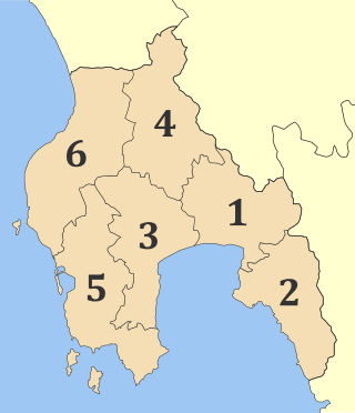
Messenia or Messinia is a regional unit in the southwestern part of the Peloponnese region, in Greece. Until the implementation of the Kallikratis plan on 1 January 2011, Messenia was a prefecture (nomos) covering the same territory. The capital and largest city of Messenia is Kalamata.
Arna is a village on the eastern slopes of the Taygetus mountain range, at an altitude of 700 to 850 m.

Gargalianoi is a town and a former municipality in Messenia, Peloponnese, Greece. Since the 2011 local government reform it is part of the municipality Trifylia, of which it is a municipal unit. The municipal unit has an area of 122.680 km2. It is situated 4 km (2.5 mi) from the Ionian Sea coast, 18 km (11 mi) north of Pylos, 21 km (13 mi) south of Kyparissia and 43 km (27 mi) west of Kalamata. The Greek National Road 9 passes through the town.

Filiatra, is a town and a former municipality in Messenia, Peloponnese, Greece. Since the 2011 local government reform it is part of the municipality Trifylia, of which it is a municipal unit. The municipal unit has an area of 114.877 km2. Filiatra is situated near the Ionian Sea coast in western Messenia. It is located 11 km northwest of Gargalianoi, 13 km southwest of Kyparissia, 29 km northwest of Pylos and 49 km west of Kalamata. The Greek National Road 9 passes through the town. Filiatra was founded around the 12th and the 13th centuries. It was built near the site of the ancient city Erana. Filiatra has several schools, churches and shops. A scaled reproduction of the Eiffel Tower stands at the entrance to the village. The local soccer club is Erani Filiatra.

Andritsaina is a village, a community and a former municipality in Elis, West Greece, Greece. Since the 2011 local government reform it is part of the municipality Andritsaina-Krestena, of which it is a municipal unit. The municipal unit has an area of 131.247 km2.
Meropi is a village and a community in the municipality of Oichalia, in Messenia, Greece. It is located in the plains of northern Messenia, west of the Taygetus mountains. It is near a major highway linking Kalamata and Corinth, the Greek National Road 7. It is 1.5 km south of Oichalia, 3.5 km northeast of Meligalas, 21 km southwest of Megalopoli and 26 km north of Kalamata. In 2021 its population was 484 for the community, which consists of the villages Meropi, Allagi and Mousta.

Petalidi is a village and a former municipality in Messenia, Peloponnese, Greece. Since the 2011 local government reform it is part of the municipality Messini, of which it is a municipal unit. The municipal unit has an area of 104.970 km2. Petalidi is situated on the western shore of the Messenian Gulf, 14 km southwest of Messini, 20 km southwest of Kalamata and 25 km east of Pylos. The road Greek National Road 82 passes through the north of the municipal unit. Its population is 1,203 inhabitants, while the municipal unit has 2,555 residents (2021).

East Mani is a municipality in Laconia, Peloponnese, Greece. Its seat of administration is the town Gytheio. It is a mountainous and rocky area. Its economy relies on fishing, olive oil and tourism.

Aghios Nikolaos, Agios Nikolaos or Saint Nicholas, is a fishing village in the Mani Peninsula in southern Greece about 30 kilometres (19 mi) south-east of Kalamata, on the eastern shore of the Messenian Gulf, and about 4 kilometres (2.5 mi) south of Stoupa, a larger tourist village. It is part of the municipality of West Mani in Messenia.
Kopanaki is a town in northwestern Messenia, Peloponnese, Greece. It was the seat of the former municipality of Aetos and now it belongs to the municipality of Trifylia. Agriculture, specifically olive farming, is the main economic activity in the village. The community Kopanaki also includes the small villages Agios Dimitrios and Rizochori. Being the geographical and economic center of upper Trifylia, Kopanaki is well known for "pazari" (bazaar) or "agora", that takes place in the central square every Sunday since 1900 and attracts further population. The messenian tradition of baking "gournopoula" (pork) and selling it on the edge of the street started from this location, initially only on Sundays, for the visitors from far away, so they could have a hearty meal and the power to do the return trip. Today in many places of the region lying on main road someone can find grilled gournopoula.
Doloi is a community of the municipality West Mani, in Messenia, southern Greece. The community consists of the villages Kato Doloi, Ano Doloi, Kitries, Kalianaiika and Geranou. Doloi is located in the northwestern part of the Mani peninsula, on the east coast of the Messenian Gulf. It is 3 km west of Kampos, 4 km southeast of Avia and 12 km southeast of Kalamata. Kitries is on the coast, the other villages are in the hills.
Avia is a village and a former municipality in Messenia, Peloponnese, Greece. Since the 2011 local government reform it is part of the municipality West Mani, of which it is a municipal unit. The municipal unit has an area of 179.828 km2. The seat of the municipality was in Kampos. Avia is a popular tourist destination. It also has a large olive production. Avia is situated on the east coast of the Messenian Gulf, southeast of Kalamata, southwest of Sparta and northwest of Kardamyli.

Lefktro is a village and a former municipality in Messenia, Peloponnese, Greece. Since the 2011 local government reform it is part of the municipality West Mani, of which it is a municipal unit. The municipal unit has an area of 222.981 km2. Its population is 4,699 (2011). The seat of the municipality was in Kardamyli. The village Lefktro is located above the larger village of Stoupa. Also known as Choriadaki, it contains some restored Mani towers and a few newer houses, virtually all built in the traditional style, of local stone. A ten-minute walk to the sea and Stoupa's beach, it is on the slopes leading up to the Taygetos mountains.
Tourkolekas is a settlement in the municipal unit of Falaisia, southwest Arcadia, Greece. It is situated in the mountains near the border with Messenia, at about 800 m elevation. It is 5 km west of Kamara, 6 km northeast of Pefko (Messenia), 8 km southwest of Leontari and 17 km south of Megalopoli. Every August, Tourkolekas celebrates its Nikitareia festival in honour of Nikitaras, a Greek revolutionary leader. There is a marble statue of Nikitaras in the village.

Kampos is a village and a community in the Mani Peninsula, in Messenia in southern Greece. It was the seat of the former municipality of Avia. Kampos had 367 inhabitants in 2021. It is located at height of 350m, on the provincial road Kalamata-Areopoli, 22 km. away from Kalamata.

Megali Mantineia is a mountain settlement in the municipal unit of Avia, Messenia, Greece. It sits at 200m above sea level, 2 km southeast of Avia, 3 km south of Mikri Mantineia and 10 km southeast of Kalamata. Many of its residents only stay there during the summer months.
Mikri Mantineia is a seaside village in the municipality of Kalamata, Messenia, Greece. It is situated at 20 m above sea level, on the northeastern shore of the Gulf of Messenia. Its main industry is tourism. Mikri Mantineia is 2 km northeast of Avia, 3 km north of Megali Mantineia and 6 km southeast of Kalamata.
Artemisia is a mountain village and a community in the municipality of Kalamata, Messenia, Greece. The community includes the small village Agios Ioannis Theologos. It is situated at 860 m above sea level. Many of its residents live there only during the summer months.

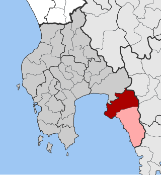
West Mani is a municipality in the Messenia regional unit, Peloponnese, Greece. The seat of the municipality is the town Kardamyli. The municipality has an area of 402.809 km2.
