
Mount Hope is an ethnically diverse, hilly urban neighborhood of the City of San Diego, California. Located in the southeastern portion of the city, Mount Hope is named for the large municipal Mount Hope Cemetery, which encompasses approximately 115 acres (0.47 km2) of the community. The neighborhood contains a mixture of residential, industrial, commercial, and cemetery uses.
The College Area is a residential community in the Mid-City region of San Diego, California, United States. The College Area is dominated by San Diego State University, after which the area is named. Several neighborhoods in the College Area were developed in the 1930s, with others becoming established in the post-war period. The College Area is bordered on the west by Kensington and Talmadge and on the east by the city of La Mesa. El Cajon Boulevard is a busy shopping district; additional retail, entertainment and dining establishments are located in a new housing and commercial complex known as South Campus Plaza on College Avenue at Aztec Center. The College Area includes the neighborhoods of the Catoctin Area, Dennstedt Point, East Falls View Drive, Saranac-Mohawk, and an Orthodox Jewish neighborhood in the area near Congregation Beth Jacob Orthodox Synagogue on College Avenue. The region includes Alvarado Hospital, a 306-bed acute care facility, and the College-Rolando branch of the San Diego Public Library.
Del Cerro is a hilly residential neighborhood of approximately 2,300 residents in the eastern part of San Diego, California. Del Cerro borders the communities of San Carlos, Allied Gardens, College Area, Grantville, and the city of La Mesa, and is adjacent to Lake Murray and San Diego State University. For planning purposes the city includes it in the Navajo community planning area.
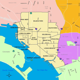
South Park is a neighborhood in San Diego, California adjacent to the southeast corner of Balboa Park. It stands out in San Diego for its tree-lined streets and walkable business district.
Allied Gardens is a residential neighborhood in the eastern Navajo community of San Diego, California. It neighbors San Carlos to the east, Del Cerro to the south, the College Area to the southeast and Grantville to the southwest.
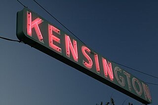
Kensington is a neighborhood of San Diego, California. Its borders are defined by Interstate 15 to the west, Interstate 8 to the north, Fairmount Avenue to the east, and El Cajon Boulevard to the south. Its neighboring communities are Normal Heights to the west, and City Heights to the south. Kensington is part of San Diego City Council District 9. In the United States House of Representatives, Kensington is in California's 53rd congressional district, represented by Democrat Sara Jacobs,
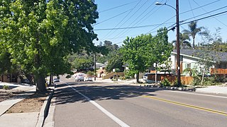
Talmadge is a neighborhood of the mid-city region of San Diego, California. Its borders are defined by Fairmount Avenue to the West, Montezuma Road/Collwood Boulevard to the Northeast, and El Cajon Boulevard to the South.

Grantville is a middle-class neighborhood in the city of San Diego, in California. It borders the communities of Allied Gardens, San Carlos, Tierrasanta and Mission Valley East.
El Cerrito is a neighborhood of the Mid-City region of San Diego, California. El Cerrito is a residential neighborhood, consisting mostly of suburban homes, with some commercial activity along the streets that define its borders.
Webster is a neighborhood of the Mid-City region of San Diego, California.

The Azalea Park neighborhood is a community within City Heights in the greater San Diego, California area. It is located on top of a plateau 3 miles east of San Diego Bay, with an elevation of around 300 feet. It is bordered to the north by Manzanita Canyon Fairmount Avenue to the east, Interstate 805 to the west, and Hollywood Park to the south.
Rancho Encantada is a suburban neighborhood in San Diego, California, United States. It is bordered by the City of Poway to the north, the San Diego neighborhood of Scripps Ranch to the west, Marine Corps Air Station Miramar to the south, and unincorporated and undeveloped San Diego County to the east.
Loma Portal is a neighborhood in the community of Point Loma in San Diego, California. It is a hilly area northwest of Rosecrans Street and northeast of Nimitz Boulevard, overlooking San Diego Bay.
Roseville-Fleetridge is a neighborhood in Point Loma, San Diego, California. It is bounded by San Diego Bay and Rosecrans Street on the east, Cañon Street on the south, Catalina Boulevard on the west and Chatsworth and Nimitz Boulevards on the north. Neighboring communities are Point Loma Heights and Loma Portal to the north, Point Loma Village and Liberty Station to the east, La Playa and the Wooded Area to the south, and Sunset Cliffs to the west. It is actually two separate neighborhoods, Roseville and Fleetridge, which the city lumps together for policing purposes.
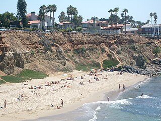
Sunset Cliffs is an affluent coastal community in the Point Loma community of San Diego, California. It is bordered by the Pacific Ocean on the west, Ocean Beach on the north, Catalina Blvd. and Santa Barbara St. on the east, and Sunset Cliffs Natural Park on the south.

The Wooded Area is a neighborhood within the community of Point Loma, San Diego, California. It encompasses the hilltop area south of Talbot Street on both sides of Catalina Boulevard; the area west of Catalina is also referred to as the College Area. The Wooded Area borders Naval Base Point Loma to the south, La Playa to the east, Roseville-Fleetridge to the north, and Sunset Cliffs and Point Loma Nazarene University to the west. The boundaries of the neighborhood are not universally agreed upon, with different maps showing different borders.
Shelltown is a neighborhood located within Southeast San Diego, approximately 5 minutes from downtown San Diego by car and 25 minutes by bicycle. It is bordered by National City on the south, Interstate 5 and Barrio Logan on the west, 43rd Avenue on the east, and Gamma Court and the neighborhood of Southcrest on the north. Prior to the 1980s the northern border of Shelltown was National Ave and many residents still consider that the northern border.

Valencia Park is an urban community in the southeastern section of the city of San Diego. It is bordered by Emerald Hills and Market Street on the north, Lincoln Park and Euclid Avenue on the west, Encanto on the east, and Alta Vista and National City, California on the south. Major thoroughfares include Imperial Avenue, Churchward Street, and Valencia Parkway.
Fairmount Park is a neighborhood of San Diego, California. Its borders are defined by Interstate 15 to the west, Interstate 805 to the east and California Highway 94 to the south. Its neighboring communities are South Park and Golden Hill to the west, Azalea Park and City Heights to the east, and Webster to the south. It is primarily residential, mostly single-family homes, with a small commercial area along Home Avenue including several restaurants and convenience stores. Bayridge is a small neighborhood within Fairmount Park on its westernmost knoll, identifiable by its outstanding views and well-maintained townhouse development. Fairmount Park is 3 miles from Downtown San Diego. Chollas Creek runs through it.

Jamacha is a neighborhood in the southeastern area of San Diego, California. It is generally bounded by the city of Lemon Grove to the north, unincorporated La Presa to the east, Imperial Avenue and Encanto to the west, and Skyline and Lomita Village to the south. Major thoroughfares include Lisbon Street, Jamacha Road, and Woodrow Avenue. The neighborhood is part of the Skyline-Paradise Hills Community Planning Area.