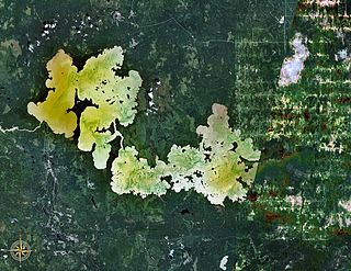
Lake Abitibi is a shallow lake in northeastern Ontario and western Quebec, Canada. The lake, which lies within the vast Clay Belt, is separated in two distinct portions by a short narrows, making it actually 2 lakes. Its total area is 931 square kilometres (359 sq mi), and net area 903 square kilometres (349 sq mi). The lake is shallow and studded with islands. Its shores and vicinity are covered with small timber.

The Ottawa River is a river in the Canadian provinces of Ontario and Quebec. It is named in honour of the Algonquin word 'to trade', as it was the major trade route of Eastern Canada at the time. For most of its length, it defines the border between these two provinces. It is a major tributary of the St. Lawrence River and the longest river in Quebec.

Algonquin people are an Indigenous people of Eastern Canada. They speak the Algonquin language, a divergent dialect of the Ojibwe language, which is part of the Algonquian language family. Culturally and linguistically, they are closely related to the Odawa, Potawatomi, Ojibwe, and Nipissing, with whom they form the larger Anicinàpe (Anishinaabeg). The Algonquin people call themselves Omàmiwinini or the more generalised name of Anicinàpe.

Algonquin Provincial Park is a provincial park located between Georgian Bay and the Ottawa River in Ontario, Canada, mostly within the Unorganized South Part of Nipissing District. Established in 1893, it is the oldest provincial park in Canada. Additions since its creation have increased the park to its current size of about 7,653 square kilometres (2,955 sq mi). The park is contiguous with several smaller, administratively separate provincial parks that protect important rivers in the area, resulting in a larger total protected area.
Eau Claire is the name of a number of locations and features in North America. The name is pronounced as if it were spelled "O'Clare".

The French River is a river in Central Ontario, Canada. It flows 110 kilometres (68 mi) from Lake Nipissing west to Georgian Bay. The river largely follows the boundary between the Parry Sound District and the Sudbury District, and in most contexts is considered the dividing line between Northern and Southern Ontario. The French River was designated a Canadian Heritage River in 1986.

The Mattawa River is a river in central Ontario, Canada. It flows east from Trout Lake east of North Bay and enters the Ottawa River at the town of Mattawa. Counting from the head of Trout Lake, it is 76 km in length. The river's name comes from the Algonquin word for "meeting of waterways".

The Petawawa River is a river in the Saint Lawrence River drainage basin in Nipissing District and Renfrew County in eastern and northeastern Ontario, Canada. The river flows from Algonquin Provincial Park to the Ottawa River at the town of Petawawa, and is only one of two major tributaries of the Ottawa River to flow completely free. The river's name comes from the Algonquian for "where one hears a noise like this", which refers to its many rapids.
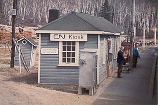
Kiosk is an unincorporated place and former railway point and community in geographic Pentland Township in the Unorganized South Part of Nipissing District in northeastern Ontario, Canada. Kiosk is surrounded by but not within Algonquin Provincial Park, for which it provides a road access point via Ontario Highway 630, and is located on Kioshkokwi Lake on the Amable du Fond River on the right bank of the outlet of that river from the lake and across the river from the unincorporated place of Coristine. The name "Kiosk" is an abbreviated form of the lake's name, which means "lake of many gulls".

Mattawa is a town in northeastern Ontario, Canada on Algonquin Nation land at the confluence of the Mattawa and Ottawa Rivers in Nipissing District. Mattawa means "Meeting of the Waters" in the Algonquin language. The first Europeans to pass through this area were Étienne Brûlé and Samuel de Champlain.

Samuel de Champlain Provincial Park is a provincial park in Ontario, Canada.

The Manitou Islands are a series of small islands in Lake Nipissing, in Nipissing District, Ontario, Canada. The islands form a circle and lie 10 kilometres (6 mi) southwest of North Bay.

The Gull River is a river in Algonquin Highlands and Dysart et al, Haliburton County and the single-tier municipality of Kawartha Lakes in south-central Ontario, Canada. It is in the Trent River and Lake Ontario drainage basins, and flows from southern Algonquin Provincial Park to Balsam Lake on the Trent–Severn Waterway.

North Tea Lake is a lake in the Ottawa River drainage basin in the geographic townships of Ballantyne and Wilkes in the Unorganized South Part of Nipissing District in Northeastern Ontario, Canada. It is on the Amable du Fond River and lies in the northwest of Algonquin Provincial Park. The lake is a popular destination for canoeists.
North River may refer to one of five rivers in Ontario, Canada:
Mink Lake is an unincorporated place and former railway point in geographic Pentland Township in the Unorganized South Part of Nipissing District in northeastern Ontario, Canada. Mink Lake is located within Algonquin Provincial Park at the eastern end of Mink Lake in the Amable du Fond River drainage basin.
Coristine is an unincorporated place and former railway point in geographic Pentland Township in the Unorganized South Part of Nipissing District in northeastern Ontario, Canada. Coristine is located within Algonquin Provincial Park on Kioshkokwi Lake on the Amable du Fond River, on the right bank of the outlet of that river from the lake and opposite the settlement of Kiosk.
Kilrush is an unincorporated place and former railway point in geographic Boulter Township in the Unorganized South Part of Nipissing District in northeastern Ontario, Canada. Kilrush is located northwest of the northwest side of Algonquin Provincial Park on Kilrush Lake in the Amable du Fond River drainage basin.
Abitibi-De-Troyes Provincial Park is in Cochrane District of Northern Ontario, Canada, and protects Long Point Peninsula, and small section of the Abitibi River from the lake's outlet to Couchching Falls, as well as the lake's southern shore between the peninsula and outlet. It was established in 1985 and provides backcountry canoeing, camping, hunting, fishing and nature viewing activities. The park is named after Pierre de Troyes who may have portaged across Long Point during his Hudson Bay expedition in 1686.


