
Chios is the fifth largest Greek island, situated in the northern Aegean Sea, and the tenth largest island in the Mediterranean Sea. The island is separated from Turkey by the Chios Strait. Chios is notable for its exports of mastic gum and its nickname is "the Mastic Island". Tourist attractions include its medieval villages and the 11th-century monastery of Nea Moni, a UNESCO World Heritage Site.

Paros is a Greek island in the central Aegean Sea. Part of the Cyclades island group, it lies to the west of Naxos, from which it is separated by a channel about 8 kilometres wide. It lies approximately 150 km south-east of Piraeus. The Municipality of Paros includes numerous uninhabited offshore islets totaling 196.308 square kilometres (75.795 sq mi) of land. Its nearest neighbor is the municipality of Antiparos, which lies to its southwest. In ancient Greece, the city-state of Paros was located on the island.

Icaria, also spelled Ikaria, is a Greek island in the Aegean Sea, 10 nautical miles (19 km) southwest of Samos.

Folegandros is a small Greek island in the Aegean Sea that, together with Sikinos, Ios, Anafi and Santorini, forms the southern part of the Cyclades. Its surface area is 32.216 square kilometres (12.439 sq mi) and it has 719 inhabitants (2021). It has three small villages, Chora, Karavostasis, and Ano Meria, which are connected by a paved road. Folegandros is part of the Thira regional unit.

Syros, also known as Siros or Syra, is a Greek island in the Cyclades, in the Aegean Sea. It is 78 nautical miles (144 km) south-east of Athens. The area of the island is 83.6 km2 (32 sq mi) and at the 2021 census it had 21,124 inhabitants.
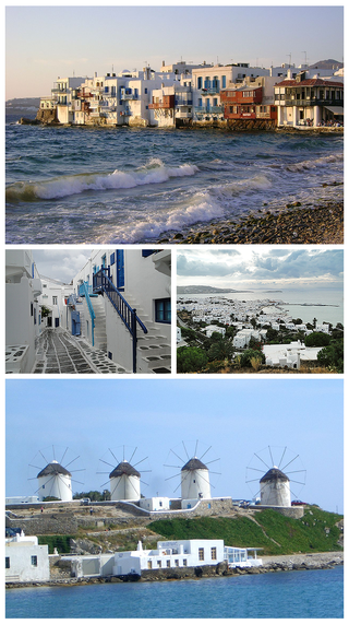
Mykonos is a Greek island, part of the Cyclades, lying between Tinos, Syros, Paros and Naxos. The island has an area of 85.5 square kilometres (33.0 sq mi) and rises to an elevation of 341 metres at its highest point. At the 2021 census, there were 10,704 inhabitants, most of whom lived in the largest town, Mykonos, which is on the west coast. The town is also known as Chora.

Psara is a Greek island in the Aegean Sea. Together with the small island of Antipsara it forms the municipality of Psara. It is part of the Chios regional unit, which is part of the North Aegean region. The only town of the island and seat of the municipality is also called Psara.

Antiparos (Greek: Αντίπαρος; Ancient Greek: Ὠλίαρος, romanized: Oliaros; Latin: Oliarus; is a small island in the southern Aegean, at the heart of the Cyclades, which is less than one nautical mile from Paros, the port to which it is connected with a local ferry. Saliagos island is the most ancient settlement in the Cyclades, and Despotiko, an uninhabited island in the southwest of Antiparos, is a place of great archaeological importance.
Tinos is a Greek island situated in the Aegean Sea. It is part of the Cyclades archipelago. The closest islands are Andros, Delos, and Mykonos. It has a land area of 194.464 square kilometres (75.083 sq mi) and a 2021 census population of 8,934 inhabitants.
Volissos is the largest village in the northwest part of Chios, Aegean Islands, Greece. The village is situated 40 km away from the main town of Chios.

Alonnisos, also transliterated as Alonissos, is a Greek island in the Aegean Sea. After Skiathos and Skopelos it is the third member of the Northern Sporades. It is 3 km (2 mi) (2 nm) east of the island of Skopelos. Alonnisos is also the name of a village on the island, as well as the municipality that encompasses the island and the village.

Agia Paraskevi (Greek: Αγία Παρασκευή, also Ayia Paraskevi is a village and a former municipality on the island of Lesbos, North Aegean, Greece. Since the 2019 local government reform it is part of the municipality of West Lesvos, of which it is a municipal unit. It is located in the central part of the island, on the northeast shore of Kalloni Bay. The village is named after the Church of Agia Paraskevi, which is found in a cave in one of the highest points of the town. The town cemetery is also located there. Presumably built over an old pagan temple, there is a well in the cave, and drinking the water from this well has been said to have conferred the Virgin Mary's protection. Agia Paraskevi is an old village that is becoming a powerful cultural and economic center for the island. The village is known for its old mansions, unique architecture and for its festivals. It is often referred to as the « Little Paris of the Aegean », due to its quaint agora and stunning architecture.

Chios is one of the regional units of Greece. It is part of the region of North Aegean. The capital of the regional unit is the town of Chios. The regional unit consists of the islands of Chios, Psara, Oinousses and some smaller uninhabited islands, all in the Aegean Sea.

Kimolos is a Greek island in the Aegean Sea. It lies on the southwest of the island group of Cyclades, near the bigger island of Milos. Kimolos is the administrative center of the municipality of Kimolos, which also includes the uninhabited islands of Polyaigos, Agios Efstathios and Agios Georgios. The island has a land area of 36 square kilometres (13.900 sq mi), while the municipality's land area is 53.251 square kilometres (20.560 sq mi), and it reported a population of 810 inhabitants in the 2021 census.
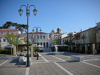
Chios is the main town and a former municipality on the island of Chios, North Aegean, Greece. Since the 2011 local government reform, it is part of the municipality Chios, of which it is a municipal unit. The municipal unit has an area of 22.823 km2. It is located on the eastern coast of the island facing the Turkish coastal town of Çeşme. The town has a population of 27,015 (2021) and is the administrative capital and main port of both the island and of the regional unit of Chios. Chios town is one of eight municipal units on the island.

Nea Koutali is a municipal unit on the island of Lemnos, North Aegean, Greece. Located in the south central portion of the island with a land area of 75.735 square kilometres (29.241 sq mi), it accounts for about 15.9% of the island's area, making it the smallest of the four municipal units on Lemnos. The seat of government is the village of Kontias, while its largest town is Nea Koutali.
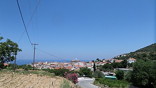
Karlovasi is a town, a municipal unit, and a former municipality on the island of Samos, North Aegean, Greece. Since the 2019 local government reform it is part of the municipality West Samos, of which it is a municipal unit and the seat. It is located on the northwest side of the island and it is considered the commercial center of the island. According to the 2021 census, the population of the municipal unit was 10,220 inhabitants. Its land area is 100.330 km2. The municipal unit shares the island of Samos with the municipal units of Vathy, Pythagoreio, and Marathokampos.

Kampochora or Kampos, literally plain, is a former municipality on the island of Chios, North Aegean, Greece. Since the 2011 local government reform it is part of the municipality Chios, of which it is a municipal unit. It is located in the south-central part of the island. It has a land area of 50.571 km². Its population was 3,014 at the 2021 census. The seat of the municipality was in Chalkeio. Other large towns include Ágios Geórgios Sykoúsis, Dafnonas, and Vasileónoikon.
Vythos, is a village in Kozani regional unit, Western Macedonia, Greece. Since the 2011 local government reform it is part of the municipality Voio, of which it is a member of the municipality unit of Pentalofos. Βυθὀς means seabed, which is a paradoxical name for a village typified by its mountainous terrain and high altitude.
Kontakaiika is a Greek village in the northwestern part of Samos, 5 km from Karlovasi. The village belongs to the municipality of West Samos. According to the 2021 census, the village has 1,076 inhabitants.
