Transport in Sri Lanka is based on its road network, which is centred on the country's commercial capital Colombo. A rail network handles a portion of Sri Lanka's transport needs. There are navigable waterways, harbours and three international airports: in Katunayake, 35 kilometres (22 mi) north of Colombo, in Hambantota, and in Jaffna.

Kegalle is a large town in Sabaragamuwa Province of Sri Lanka. It is located on the Colombo–Kandy road, approximately 78 km (48 mi) from Colombo, 40 km (25 mi) from Kandy, 32 km (20 mi) from Kurunegala and 46 km (29 mi) from Avissavella. It is the main town in the Kegalle District, which is one of two districts which comprise Sabaragamuwa Province. The town is governed by an Urban Council.

Mawanella is a town which belongs to the Kegalle district in the Sabaragamuwa Province of Sri Lanka. It lies between Kegalle and Kadugannawa along the Colombo-Kandy road. The area consists of four administrative areas, namely Mawanella, Aranayake, Rambukkana and Hemmathagama.

Badulla is the capital and the largest city of Uva Province situated in the lower central hills of Sri Lanka. It is the capital city of Uva Province and the Badulla District.

Nawalapitiya is a town in Kandy District, Sri Lanka. It is governed by an Urban Council. It is 38 km (24 mi) away from Kandy and 112 km (70 mi) from Colombo, at a height of 589 m (1,932 ft) above sea level. It is located on the banks of the Mahaweli Ganga. The area was developed during the colonisation of the island by the British, as one of the colony's centres of Coffee Production.

The Sri Lanka Railway Department is Sri Lanka's railway owner and primary operator. As part of the Sri Lankan government, it is overseen by the Ministry of Transport. Founded in 1858 as the Ceylon Government Railway, it operates the nation's railways and links Colombo with other population centres and tourist destinations.
Polgahawela is a town located in north western Sri Lanka. It is most notable for being a major railway junction.

Meemure is a village with a population of about 420 people living in it It is located near the border between Kandy District and Matale District in the Knuckles Mountain Range. Meemure is one of the most remote villages in Sri Lanka with the only access via a 14 km (8.7 mi) trail from the town of Loolwatte. There is no cellular service available in the village, but a CDMA telephone service is available. There is no direct mail delivery to the village; a villager journeys each day to Thapal Junction to exchange incoming and outgoing postal mail with a postman.
The A 1 road is an A-Grade trunk road in Sri Lanka. It connects the capital city of Colombo with Kandy.
Medawachchiya is a town in the Anuradhapura District, North Central Province of Sri Lanka. Situated 27 km from Anuradhapura, on the A9 Jaffna - Kandy main road, it is 229 km from Colombo. Medawachchiya is also the point from which the A14 main road to Mannar and Talaimannar starts. Medawachchiya is a significant railway junction on Sri Lanka Railways' northern network. Medawachchiya is the junction between the Northern Line and the Mannar Line.
Mangalagama is an ancient village in Sri Lanka. It is located within the Rambukkana Division in the Kegalle District in Sabaragamuwa Province, Sri Lanka. Managlagama is situated by the Colombo - Kandy main road, 87 km away from Colombo / 28 km away from Kandy. The nearest towns are: Kegalla (6 km) and Mawanella (4 km). The post office that covers Managlagama is: Molagoda (2 km).

The Main Line is a major railway line in the rail network of Sri Lanka and considered by many to be one of the most scenic train journeys in all of Asia. The line begins at Colombo Fort and winds through the Sri Lankan hill country to reach Badulla.

Kandy railway station is a major railway station in Kandy, Sri Lanka. The station is served by Sri Lanka Railways and is the primary railway station in Kandy and one of the most significant in the central hills. The station sits on a branch of the Main Line, leading to the Matale Line.

Peradeniya Junction is a railway station on the Main railway line of Sri Lanka, situated between Kathaluwa and Koshinna railway stations. It is the 45th railway station on the Main line and situated about 115 kilometres (71 mi) away from the Colombo Fort Railway Station, at an elevation of about 476 metres (1,562 ft) above sea level. It is an important railway junction in Sri Lanka Railways' network, connecting the Main Line, which runs from Colombo to Badulla and the Matale Line, which runs from Peradeniya to Matale via Kandy.

AlagallaMountain Range is situated at the boundaries of the Central and Sabaragamuwa Provinces in Sri Lanka. Along with the surrounding Bathalegala (බතලේගල) also known as Bible Rock, Uthuwankanda (උතුවන්කන්ද), Devanagala (දෙවනගල), Ambuluwawa (අම්බුළුවාව), Knuckles Mountain Range and Hanthana (හන්තාන) Mountain Range, Alagalla mountain has served as a natural defense location for nearly five centuries (1505–1948) against the Portuguese, Dutch and English invasions aimed at the Kandyan Kingdom.

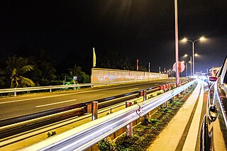
The Central Expressway (E04), is an under construction road project that will link the Sri Lankan capital, Colombo, with Dambulla & Kandy. It will provide a fast alternative to the existing A1 Colombo - Kandy & A6 Ambepussa - Trincomalee Highways. The Expressway starts at the Kadawatha Interchange on the E02 Outer Circular Expressway and ends in Dambulla at the A9 Kandy - Jaffna Highway, traversing through Gampaha, Kurunegala & Matale Districts. A link Expressway starting from Pothuhera & ending in Galagedara will provide access to the Kandy District.
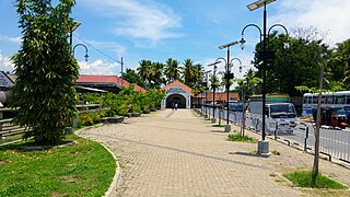
Rambukkana Railway Station is a railway station in the Kegalle District, Sabaragamuwa Province, Sri Lanka. The station is served by Sri Lanka Railways, which is the state-run railway operator.

Alawwa Railway Station is a railway station in the town of Alawwa, which is located in the Kurunegala District of Sri Lanka. The station is owned by Sri Lanka Railways, the state-owned railway operator, the station is part of the Main line which links Badulla with the country's capital Colombo.

Polgahawela Junction railway station is a major junction station, situated in the Kurunegala District, North Western Province, Sri Lanka. It is the 34th railway station on the Main line and is 73.83 kilometres (45.88 mi) away from the Colombo Fort Railway Station, at an elevation of 74.39 metres (244.1 ft) above sea level. The station is located at the centre of Polgahawela and is a main junction point joining two railway lines; one coming from the upcountry of Sri Lanka and another from the northern part of the country.
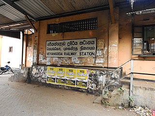
Veyangoda railway station is a railway station in the Western Province, Sri Lanka. The station is served by Sri Lanka Railways, which is the state-run railway operator.
