A1 highway | |
---|---|
Route information | |
Part of Asian Highway AH43 | |
Maintained by the Road Development Authority | |
Length | 115.85 km (71.99 mi) |
Existed | 1820–present |
Major junctions | |
West end | Colombo |
East end | Kandy |
Location | |
Country | Sri Lanka |
Major cities | Kegalle, |
Highway system | |
|
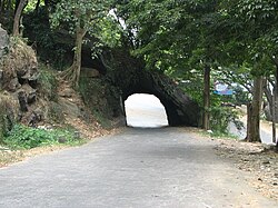
The A 1 road (commonly known as the Colombo - Kandy Road or just the Kandy Road) is an A-Grade trunk road in Sri Lanka. It connects the capital city of Colombo with Kandy.
Commonly known as the Kandy Road, the A 1 was the first modern highway in the island. Construction began in 1820 under the orders of the British Governor of Ceylon, Sir Robert Wilmot-Horton, 3rd Baronet. Construction was carried out by Captain William Francis Dawson—who died during the project—along with Major Thomas Skinner. In the memory of Captain Dawson, the Dawson Tower was erected at Kadugannawa in the Kadugannawa Pass.
The A1 highway begins at Colombo Fort. It passes through Peliyagoda, Kelaniya, Kiribathgoda, Mahara, Kadawatha, Kirillawala, Imbulgoda, Balummahara, Miriswaththa, Yakkala, Weediyawaththa, Thihariya, Nittambuwa, Pasyala, Wewaldeniya, Danovita, Warakapola, and Ambepussa. At Ambepussa, Kurunegala, Mawathagama, Weuda the A6 Highway branches off the A1, heading towards Kurunegala. The A1 continues east, passing Tholangamuwa, Udukumbura, Nelundeniya, Yattogoda, Galigamuwa, Ambanpitiya, Ranwala, Kegalle, Meepitiya, Karandupana, Molagoda, Uthuwankanda, Anwarama, Mawanella, Beligammana, Hingula, Kadugannawa, Pilimathalawa, Kiribathkumbura, and Peradeniya to reach Kandy.
Here are some photos of A1 Highway and notable places found along it.
Transport in Sri Lanka is based on its road network, which is centred on the country's commercial capital Colombo. A rail network handles a portion of Sri Lanka's transport needs. There are navigable waterways, harbours and three international airports: in Katunayake, 35 kilometres (22 mi) north of Colombo, in Hambantota, and in Jaffna.
Kandy is a major city in Sri Lanka located in the Central Province. It was the last capital of the ancient kings' era of Sri Lanka. The city lies in the midst of hills in the Kandy plateau, which crosses an area of tropical plantations, mainly tea. Kandy is both an administrative and religious city and is also the capital of the Central Province. Kandy is the home of the Temple of the Tooth Relic, one of the most sacred places of worship in the Buddhist world. It was declared a world heritage site by UNESCO in 1988. Historically the local Buddhist rulers resisted Portuguese, Dutch, and British colonial expansion and occupation.
Battaramulla is a suburb of Colombo, situated 8.4 km (5 mi) from the city centre at Colombo Fort, near the Parliament of Sri Lanka. It is one of the fastest developing administrative, commercial and residential areas in the Colombo District, being home to the country's elite. Battaramulla is an important town in Sri Lanka, because of the Sri Lankan government's decision to locate all the government department head offices in this town.
Asian Highway 43 (AH43) is a route of the Asian Highway Network, running 3,024 kilometres (1,879 mi) from Asian Highway 1 in Agra, India to Matara in Sri Lanka.
The Sri Lanka Railway Department is Sri Lanka's railway owner and primary operator. As part of the Sri Lankan government, it is overseen by the Ministry of Transport. Founded in 1858 as the Ceylon Government Railway, it operates the nation's railways and links Colombo with other population centres and tourist destinations.
Ambepussa is a town in the Kegalle District, Sabaragamuwa Province, Sri Lanka.
Mirigama is a town in Gampaha District, Sri Lanka. It is located 57 km (35 mi) from Colombo, and 34 km (21 mi) from Negombo.
Kadugannawa is a town in Kandy District in the Central Province of Sri Lanka, governed by an Urban Council. It is located along the A1 road west of Peradeniya. The town is served by Kadugannawa Railway Station and has the Kadugannawa Central College.
The Colombo Outer Circular Expressway is a highway in Colombo, Sri Lanka. It was opened in sections. The 29 km (18 mi) long outer circular road network links the Colombo - Matara Expressway with Colombo - Katunayake Expressway and the proposed Colombo - Kandy Expressway and will provide an orbital beltway to bypass the city of Colombo and reduce traffic congestion. The project is funded by the Japan International Cooperation Agency (JICA). The expressway is named "Arthur C. Clarke Expressway" in honor of Arthur C. Clarke, a famous science fiction writer and futurist who lived in Sri Lanka from 1956 to his death in 2008.
The A4 Highway also known as the Colombo-Batticaloa highway, is the longest highway in Sri Lanka, at 430 kilometres (270 mi) in length. It connects Colombo with Batticaloa, through many important cities in Western, Sabaragamuwa, Uva and Eastern provinces.
Captain William Francis Dawson was a prominent road builder in British Ceylon. An Engineer attached to the Royal Engineers, he was given the task of building the Colombo - Kandy Road linking Colombo and Kandy. The job took its toll on Dawson, who died before it was completed. It would be the first modern highway in the island. In the memory of Captain Dawson, the Dawson Tower was erected at Kadugannawa in the Kadugannawa Pass.
Dawson Tower, is located on Kadugannawa in the Kadugannawa Pass next to the Colombo - Kandy Road, the first modern highway in the island. Work began on the Colombo - Kandy Road in 1820 under the direction of Captain William Francis Dawson who died during the project. The Dawson Tower was erected in memory of Dawson.
Katugastota is a suburb of the city of Kandy in Kandy District, Central Province of Sri Lanka. It is located along the Kandy-Jaffna A9 highway approximately 4 km (2.5 mi) from the city center of Kandy. Katugastota is one of the three main entry points to the city of kandy. Two major Highways meet at the center of the city which makes Katugastota one of the busiest suburbs in Kandy district.
The Main Line is a major railway line in the rail network of Sri Lanka and considered by many to be one of the most scenic train journeys in all of Asia. The line begins at Colombo Fort and winds through the Sri Lankan hill country to reach Badulla.
AlagallaMountain Range is situated at the boundaries of the Central and Sabaragamuwa Provinces in Sri Lanka. Along with the surrounding Bathalegala (බතලේගල) also known as Bible Rock, Uthuwankanda (උතුවන්කන්ද), Devanagala (දෙවනගල), Ambuluwawa (අම්බුළුවාව), Knuckles Mountain Range and Hanthana (හන්තාන) Mountain Range, Alagalla mountain has served as a natural defense location for nearly five centuries (1505–1948) against the Portuguese, Dutch and English invasions aimed at the Kandyan Kingdom.
Danowita is a small town in the western province of Sri Lanka. It is 50 kilometres (31 mi) to Colombo, 59 kilometres (37 mi) to Kandy, and 45 kilometres (28 mi) to Kurunagala. The A1 highway passes by Danowita. Bandaranaike International Airport is the nearest airport.
Balana Fort was a fortified pass of the Kingdom of Kandy llocated near the Alagalla Mountain Range, Sri Lanka. Balana which means the 'look out' in Sinhala, functioned as a strategic outpost and fortress of the kingdom which was situated along the historical Colombo-Kandy road.
The Central Expressway (E04), is an under construction road project that will link the Sri Lankan capital, Colombo, with Dambulla & Kandy. It will provide a fast alternative to the existing A1 Colombo - Kandy & A6 Ambepussa - Trincomalee Highways. The Expressway starts at the Kadawatha Interchange on the E02 Outer Circular Expressway and ends in Dambulla at the A9 Kandy - Jaffna Highway, traversing through Gampaha, Kurunegala & Matale Districts. A link Expressway starting from Pothuhera & ending in Galagedara will provide access to the Kandy District.
Polgahawela Junction railway station is a major junction station, situated in the Kurunegala District, North Western Province, Sri Lanka. It is the 34th railway station on the Main line and is 73.83 kilometres (45.88 mi) away from the Colombo Fort Railway Station, at an elevation of 74.39 metres (244.1 ft) above sea level. The station is located at the centre of Polgahawela and is a main junction point joining two railway lines; one coming from the upcountry of Sri Lanka and another from the northern part of the country.
Kadugannawa Pass is a mountain pass located near Kadugannawa town in the Central Province of Sri Lanka. It is located along the Colombo-Kandy A1 highway. It is a common roadside stop for tourists to enjoy the vistas to the Kegalle valley below and view the prominent inselberg known as the Bible Rock.
Coordinates: 6°58′39″N79°55′35″E / 6.977376°N 79.926374°E