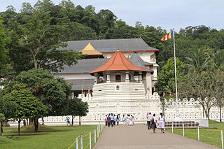
Kandy is a major city in Sri Lanka located in the Central Province. It was the last capital of the ancient kings' era of Sri Lanka. The city is situated in the midst of hills in the Kandy plateau, which crosses an area of tropical plantations, mainly tea. Kandy is both an administrative and religious city and the capital of the Central Province. Kandy is the home of the Temple of the Tooth Relic, one of the most sacred places of worship in the Buddhist world. It was declared a World Heritage Site by UNESCO in 1988. Historically the local Buddhist rulers resisted Portuguese, Dutch, and British colonial expansion and occupation.

The Kandyan Wars refers generally to the period of warfare between the British colonial forces and the Kingdom of Kandy, on the island of what is now Sri Lanka, between 1796 and 1818. More specifically it is used to describe the expeditionary campaigns of the British Army in the Kingdom of Kandy in 1803 and 1815.

Mawanella is a town which belongs to the Kegalle district in the Sabaragamuwa Province of Sri Lanka. It lies between Kegalle and Kadugannawa along the Colombo-Kandy road. The area consists of four administrative areas, namely Mawanella, Aranayake, Rambukkana and Hemmathagama.

Kurunegala is a major city in Sri Lanka. It is the capital city of the North Western Province and the Kurunegala District. Kurunegala was an ancient royal capital for 50 years, from the end of the 13th century to the start of the 14th century. It is at the junction of several main roads linking to other important parts of the country. It is about 94 kilometres (58 mi) from Colombo, 42 kilometres (26 mi) from Kandy and 51 kilometres (32 mi) from Matale.

Badulla is the capital and the largest city of Uva Province situated in the lower central hills of Sri Lanka. It is the capital city of Uva Province and the Badulla District.

Gampaha is an urban city in Gampaha District, Western Province, Sri Lanka. It is situated to the north-east of the capital Colombo. It is the sixth largest urban area in Western Province, after Colombo, Negombo, Kalutara, Panadura and Avissawella. Gampaha is also the second largest municipal centre in Gampaha district, after Negombo. Gampaha has a land area of 25.8 ha and is home to the offices of 75 government institutions.

Battaramulla is situated 8.4 km (5 mi) from the Colombo Fort, near the Parliament of Sri Lanka. It is one of the fastest developing administrative, commercial and residential areas in the Colombo District, being home to the country's elite. Battaramulla is an important town in Sri Lanka, because of the Sri Lankan government's decision to locate all the government department head offices in this town.

The Sri Lanka Railway Department is Sri Lanka's railway owner and primary operator. As part of the Sri Lankan government, it is overseen by the Ministry of Transport. Founded in 1858 as the Ceylon Government Railway, it operates the nation's railways and links Colombo with other population centres and tourist destinations.
The A 1 road is an A-Grade trunk road in Sri Lanka. It connects the capital city of Colombo with Kandy.
Captain William Francis Dawson was a prominent road builder in British Ceylon. An Engineer attached to the Royal Engineers, he was given the task of building the Colombo - Kandy Road linking Colombo and Kandy. The job took its toll on Dawson, who died before it was completed. It would be the first modern highway on the island. In memory of Captain Dawson, the Dawson Tower was erected at Kadugannawa in the Kadugannawa Pass.

Dawson Tower, is located on Kadugannawa in the Kadugannawa Pass next to the Colombo - Kandy Road, the first modern highway in the island. Work began on the Colombo - Kandy Road in 1820 under the direction of Captain William Francis Dawson who died during the project. The Dawson Tower was erected in memory of Dawson.
Balana is a village in Sri Lanka. It is located within the Kandy District, Central Province.
Mangalagama is an ancient village in Sri Lanka. It is located within the Rambukkana Division in the Kegalle District in Sabaragamuwa Province, Sri Lanka. Managlagama is situated by the Colombo - Kandy main road, 87 km away from Colombo / 28 km away from Kandy. The nearest towns are: Kegalla (6 km) and Mawanella (4 km). The post office that covers Managlagama is: Molagoda (2 km).

The Main Line is a major railway line in the rail network of Sri Lanka and considered by many to be one of the most scenic train journeys in all of Asia. The line begins at Colombo Fort and winds through the Sri Lankan hill country to reach Badulla.

Kadugannawa Ambalama is a historic wayside rest that is found – on the left, when traveling from Colombo to Kandy, a few metres before the Kadugannawa Hairpin turn aka Kadugannawa pass. Built in the early 19th century during the British colonial rule in Ceylon, the Ambalama is now more than 200 years old A popular stopover for horsemen and merchants traveling from the lowlands to the ancient hill capital Kandy, this structure resembles the Kandyan Era architecture and is of archaeological value. It was renovated by the Ministry of Tourism under the technical guidance of the Department of Archeology at a cost of Rs. 300,000.00 and now this structure is considered a national heritage item of Sri Lanka.
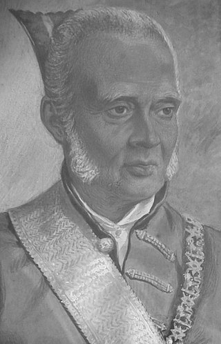
Gate Mudaliyar Jeronis de Soysa was a pioneering Ceylonese entrepreneur and philanthropist. He was a pioneer coffee planter and an industrialist who became the wealthiest Ceylonese of the 19th century by establishing the largest native commercial enterprise of the era. He was instrumental in the establishment of the first Ceylonese bank and is often referred to as a father of private enterprise in British Ceylon. He was the first Mudaliyar to be elevated in recognition of his philanthropy.

AlagallaMountain Range is situated at the boundaries of the Central and Sabaragamuwa Provinces in Sri Lanka. Along with the surrounding Bathalegala (බතලේගල) also known as Bible Rock, Uthuwankanda (උතුවන්කන්ද), Devanagala (දෙවනගල), Ambuluwawa (අම්බුළුවාව), Knuckles Mountain Range and Hanthana (හන්තාන) Mountain Range, Alagalla mountain has served as a natural defense location for nearly five centuries (1505–1948) against the Portuguese, Dutch and English invasions aimed at the Kandyan Kingdom.
Balana Fort was a fortified pass of the Kingdom of Kandy located near the Alagalla Mountain Range, Sri Lanka. Balana which means the 'look out' in Sinhala, functioned as a strategic outpost and fortress of the kingdom which was situated along the historical Colombo-Kandy road.
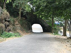
Moragalla Railway Tunnel or Lion's Mouth Tunnel is the second longest railway tunnel in Sri Lanka.

Kadugannawa Pass is a mountain pass located near Kadugannawa town in the Central Province of Sri Lanka. It is located along the Colombo-Kandy A1 highway. It is a common roadside stop for tourists to enjoy the vistas to the Kegalle valley below and view the prominent inselberg known as the Bible Rock.