Transport in Sri Lanka is based on its road network, which is centred on the country's commercial capital Colombo. A rail network handles a portion of Sri Lanka's transport needs. There are navigable waterways, harbours and three international airports: in Katunayake, 35 kilometres (22 mi) north of Colombo, in Hambantota, and in Jaffna.
Katunayake, is a suburb of Negombo in Western Province, Sri Lanka. It is the site of Bandaranaike International Airport, the primary international air gateway to Sri Lanka. With the change of government in 1977 and the introduction of the open economy policy a large area was allocated to create a free trade zone.

North Western Province is a province of Sri Lanka. It is the fourth-largest province by land area, covering 7,888 km2 (3,046 sq mi), and the fourth-most populated province with a population of over 2,592,000 people. North Western Province is bordered by the North Central Province, Sri Lanka to the north, Central Province, Sri Lanka to the east, Sabaragamuwa Province to the southeast, Western Province, Sri Lanka to the south, and is bounded by the Indian Ocean to the west.

Negombo, also known as Punchi Romaya, is a major city in Sri Lanka, situated on the west coast and at the mouth of the Negombo Lagoon, in the Western Province, 38 km (24 mi) from Colombo via the Colombo–Katunayake Expressway and the nearest major city from the Bandaranaike International Airport.
Ragama is a suburb of Gampaha, located in the Gampaha District, Western Province, Sri Lanka. It is governed by the Ja-Ela Divisional Secretariat.
The A1 road is an A-Grade trunk road in Sri Lanka. It connects the capital city of Colombo with Kandy.

Ja-Ela is a town, located approximately 20 km (12 mi) north of the city centre of Colombo, Sri Lanka. Ja-Ela lies on the A3 road which overlaps with the Colombo – Katunayake Expressway at the Ja-Ela Interchange.
Chilaw is a city in Puttalam District, North Western Province, Sri Lanka. It is governed by an urban council, whereas the outskirts are governed by a pradeshiya sabha of the same name. The town is located 80 kilometers away from Colombo via Negombo.
Kandana is a suburb of Gampaha in Western Province, Sri Lanka, 19 km (12 mi) north of the Colombo city centre. Due to the proximity to Negombo as well as the Bandaranaike International Airport, the suburb is a popular residential area. The neighboring suburbs are Ja-Ela, Ragama, Peralanda and Wattala.
Liyanagemulla is a village situated in Gampaha District, Western Province, Sri Lanka lying near the west coast to the south of the city of Negombo and is administered by the katunayake seeduwa urban council. It is located 30 km from Colombo, and 12 km from Negombo. It is on the Katunayake-Colombo road (A03) and is located a few miles from the Bandaranaike International Airport and Katunayake Export Processing Zone.

Marawila is a town in Puttalam District, North Western Province, Sri Lanka.
The A10 road is an A-Grade trunk road in Sri Lanka. It connects Katugastota with Puttalam.

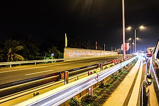
The Colombo–Katunayake Expressway E03 is Sri Lanka's second E Class highway. The 25.8-kilometre-long (16.0 mi) highway links the Sri Lankan capital Colombo with Bandaranaike International Airport, Katunayake and Negombo. Construction on the highway began in October 2009, and it was opened on 27 October 2013, by former president Mahinda Rajapaksa. The highway has three lanes each way from Colombo to Peliyagoda, and two lanes each way from Peliyagoda to Katunayake, with the width ranging from 26 to 33.5 metres.
Dankotuwa is a small town situated in Puttalam District, North Western Province, Sri Lanka. It is located 12 km (7.5 mi) away from Negombo, 47 km (29 mi) from Colombo and 62 km (39 mi) from Kurunegala. Dankotuwa is a junction town, connecting Colombo - Negombo - Kuliyapitiya main road and Negombo - Kurunegala main road. Dankotuwa Porcelain, a porcelain tableware manufacturing company, is based in Dankotuwa. The company employs 1,500 people.
The Puttalam line is a 5 ft 6 in broad gauge railway line in the rail network of Sri Lanka. The 133 km (83 mi) railway line begins at Ragama junction and runs through the major towns along the north-west coast of the country, through to Periyanagavillu. It has forty two stations along its length.

Saint Stephen's Church, Negombo, is an Anglican church in Negombo, Sri Lanka. It was consecrated on 31 July 1880 in the presence of dedicated devotees which included several Wesleyans. Service was also conducted in the Sinhalese language on the occasion when a Sinhalese woman was also baptised, under the sponsorship of two English women.

The Hamilton Canal is a 14.5 km (9.0 mi) canal connecting Puttalam to Colombo, passing through Negombo in Sri Lanka. The canal was constructed by the British in 1802 and completed in 1804. It was designed to drain salt water out of the Muthurajawela wetlands. The canal was named after Gavin Hamilton, the Government Agent of Revenue and Commerce.

Nattandiya is a town, situated in the Puttalam District, of North Western Province, Sri Lanka. The town is located 25 km (16 mi) away from Negombo, on Colombo-Negombo-Kuliyapitiya main road.
