This article needs additional citations for verification .(February 2024) |
The A16 road is an A-Grade trunk road in Sri Lanka. It connects Beragala with Hali Ela. [1]
The A16 passes through Bandarawela and Demodara to reach Hali Ela.
This article needs additional citations for verification .(February 2024) |
The A16 road is an A-Grade trunk road in Sri Lanka. It connects Beragala with Hali Ela. [1]
The A16 passes through Bandarawela and Demodara to reach Hali Ela.

Badulla is the capital and the largest city of Uva Province situated in the lower central hills of Sri Lanka. It is the capital city of Uva Province and the Badulla District.

Badulla District is a district in Uva Province, Sri Lanka. The entire land area of the Badulla district is 2,861 km2 (1,105 sq mi) and has a total population of 837,000. The district is bounded by the districts of Monaragala and Rathnapura on the east and south, by Ampara and Kandy districts to the north and by Nuwara Eliya and Matale to the west. Mainly the economy of the district is based on agricultural farming and livestock.

Demodera is a town in the central highlands of Sri Lanka, located in the Badulla District of Uva Province.

Haputale is a town of Badulla District in the Uva Province, Sri Lanka, governed by an Urban Council. The elevation is 1431 m (4695 ft) above the sea level. The area has a rich bio-diversity dense with numerous varieties of flora and fauna. Haputale is surrounded by hills covered with cloud forests and tea plantations. The town has a cooler climate than its surroundings, due to its elevation. The Haputale pass allows views across the Southern plains of Sri Lanka. The South-West boundary of Uva basin is marked by the Haputale mountain ridges, which continue on to Horton Plains and Adam's Peak to the west. CNN in 2010 named Haputale as one of Asia's most overlooked destinations.

Beragala is a small town in Sri Lanka. It is located in Badulla District of Uva Province, Sri Lanka. It is located 183 km (114 mi) away from Colombo along the A4 Highway. The area is known for its natural environment, as well as for landslides.

The A 5 road is an A-Grade trunk road in Sri Lanka. It connects the Peradeniya with Chenkalady via Badulla.

The A 15 road is an A-Grade trunk road in Sri Lanka. It connects Batticalao with Trincomallee via Tirikkondiadimadu.
The A22 road is an A-Grade trunk road in Sri Lanka. It connects Passara with Monaragala.
The A23 road is an A-Grade trunk road in Sri Lanka. It connects Wellawaya with Kumbalwela via Ella.
The A25 road is an A-Grade trunk road in Sri Lanka. It connects the Siyabalanduwa with Ampara via Damana.

The A27 road is an A-Grade trunk road in Sri Lanka. It connects Ampara with Mahaoya via Uhana.
The A31 road is an A-Grade trunk road in Sri Lanka. It connects Ampara with Karaitivu.
Hali-Ela Divisional Secretariat is a Divisional Secretariat of Badulla District, of Uva Province, Sri Lanka.
The A3 Highway is an A-Grade trunk road in Sri Lanka. It connects the Peliyagoda with Puttalam via Negombo.
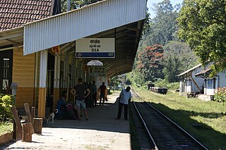
Ella is a small town in the Badulla District of Uva Province, Sri Lanka governed by an Urban Council. It is approximately 200 kilometres (120 mi) east of Colombo and is situated at an elevation of 1,041 metres (3,415 ft) above sea level. The area has a rich bio-diversity, dense with numerous varieties of flora and fauna. Ella is surrounded by hills covered with cloud forests and tea plantations. The town has a cooler climate than surrounding lowlands, due to its elevation. The Ella Gap allows views across the southern plains of Sri Lanka.
Hali-Ela electoral district was an electoral district of Sri Lanka between July 1977 and February 1989. The district was named after the town of Hali-Ela in Badulla District, Uva Province. The 1978 Constitution of Sri Lanka introduced the proportional representation electoral system for electing members of Parliament. The existing 160 mainly single-member electoral districts were replaced with 22 multi-member electoral districts. Hali-Ela electoral district was replaced by the Badulla multi-member electoral district at the 1989 general elections, the first under the proportional representation system.

Koggala Lagoon is a coastal body of water located in Galle District, Southern Sri Lanka. It is situated near the town of Koggala and adjacent to the southern coast, about 110 km (68 mi) south of Colombo. The lagoon is embellished with eight ecologically rich small islands.

St. Andrew's Church is an Anglican church in Haputale, Badulla District, Sri Lanka. This small Neo-gothic church is located on the A16 road.
The Hali Ela Polling Division is a Polling Division in the Badulla Electoral District, in the Uva Province, Sri Lanka.
6°52′10″N81°01′39″E / 6.869467°N 81.02757°E
| | This Sri Lankan road or road transport-related article is a stub. You can help Wikipedia by expanding it. |
