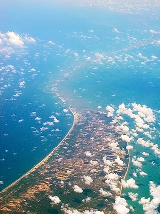
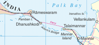
Dhanushkodi is an abandoned town at the south-eastern tip of Pamban Island of the state of Tamil Nadu in India. It is south-east of Pamban and is about 24 kilometres (15 mi) west of Talaimannar in Sri Lanka. The town was destroyed during the 1964 Rameswaram cyclone and remains uninhabited in the aftermath. Although devoid of inhabitants, Dhanushkodi remains a tourist attraction due to its historical and mythological relevance.
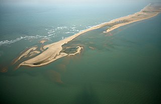
Adam's Bridge, also known as Rama's Bridge or Rama Setu, is a chain of natural limestone shoals between Pamban Island, also known as Rameswaram Island, off the southeastern coast of Tamil Nadu, India, and Mannar Island, off the northwestern coast of Sri Lanka. Geological evidence suggests that the bridge was formerly a land connection between India and Sri Lanka.
Palk Strait is a strait between the Indian state of Tamil Nadu and Northern Province of Sri Lanka. It connects the Palk Bay in the Bay of Bengal in the north with the Gulf of Mannar in the Laccadive sea in the south. It stretches for about 137 km (85 mi) and is 64 to 137 km wide. It is named after Robert Palk, who was a governor of Madras (1755–1763) during the Company Raj period.
Mannar Island, formerly spelt Manar Island, which lies off the north-western coast of Sri Lanka, is part of Mannar District, Sri Lanka. It is linked to the main island of Sri Lanka by a causeway and the Mannar Bridge, which carries the A14 highway, and a railway bridge. It has an area of about 130 square kilometres (50 sq mi), mainly covered with vegetation and sand.
Asian Highway 43 (AH43) is a route of the Asian Highway Network, running 3,024 kilometres (1,879 mi) from Asian Highway 1 in Agra, India to Matara in Sri Lanka.
The A9 Highway is a 321-kilometer-long (199 mi) highway in Sri Lanka, which connects the central city of Kandy with Jaffna, a city on the northern tip of the island.

The Sri Lanka Railway Department is Sri Lanka's railway owner and primary operator. As part of the Sri Lankan government, it is overseen by the Ministry of Transport. Founded in 1858 as the Ceylon Government Railway, it operates the nation's railways and links Colombo with other population centres and tourist destinations.

Talaimannar is a settlement in Sri Lanka located on the northwestern coast of Mannar Island.
Medawachchiya is a town in the Anuradhapura District, North Central Province of Sri Lanka. Situated 27 km from Anuradhapura, on the A9 Jaffna - Kandy main road, it is 229 km from Colombo. Medawachchiya is also the point from which the A14 main road to Mannar and Talaimannar starts. Medawachchiya is a significant railway junction on Sri Lanka Railways' northern network. Medawachchiya is the junction between the Northern Line and the Mannar Line.

Mannar is the main town of Mannar District, Northern Province, Sri Lanka. It is governed by an Urban Council. The town is located on Mannar Island overlooking the Gulf of Mannar and is home to the historic Ketheeswaram temple. In the Tamil language, Mannar means the raised place [of sand] which is thought to have come from the geology of Mannar Island which was formed by the accumulation of sand.
Thampanaikkulam, is a small town in Sri Lanka. It is located within the Mannar District, Northern Province.
The A32 road is an A-Grade trunk road in Sri Lanka. It connects the towns of Mannar and Navatkuli, both of which are in Northern Province.

Mannar Bridge is a road bridge in north-western Sri Lanka. It connects Mannar Island with the mainland and is the only road bridge to the densely populated island.
The Mannar line is a railway line in Sri Lanka. Branching off the northern line at Medawachchiya Junction, the line heads north-west through North Central and Northern provinces before terminating at the town of Talaimannar. The line is 106 kilometres (66 mi) long and has 11 stations. The line opened in 1914.
Mannar Island Lighthouse is a lighthouse in Talaimannar on Mannar Island in northern Sri Lanka. Built in 1915, the 19 metres (62 ft) white lighthouse has a round cylindrical tower with lantern and gallery.
Mannar Island Lighthouse is a lighthouse in Urumalai on Mannar Island in northern Sri Lanka. The inactive lighthouse is an iron structure.

The Palk Strait Bridge and Tunnel is a proposed 23-kilometre (14 mi) road and rail bridge and tunnel over the Palk Strait between Dhanushkodi in Tamil Nadu and Talaimannar on Mannar Island, an island off the northwestern coast of Sri Lanka.
Talaimannar Grama Niladhari Division is a Grama Niladhari Division of the Mannar Town Divisional Secretariat of Mannar District of Northern Province, Sri Lanka. It has Grama Niladhari Division Code MN/52.
