Ambivali Tarf Wankhal

Last updated

Ambivali Tarf Tungaratan
town
India Maharashtra location map.svg
Red pog.svg
Ambivali Tarf Tungaratan
Location in Maharashtra, India
Coordinates: 18°53′29″N73°10′39″E / 18.8915°N 73.1775°E / 18.8915; 73.1775 Coordinates: 18°53′29″N73°10′39″E / 18.8915°N 73.1775°E / 18.8915; 73.1775
CountryFlag of India.svg  India
State Maharashtra
District Raigad
Population (2001)
  Total 6,799
Languages
  Official Marathi
Time zone IST (UTC+5:30)
Vehicle registration MH46

Ambivali Tarf Tungaratan is a census town in Raigad district in the state of Maharashtra, India.

A census town is a type of town that satisfies certain characteristics, depending on the country in which it is located.

Raigad district District of Maharashtra in India

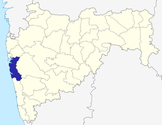
Raigad District is a district in the state of Maharashtra, India. Formerly called the Kolába district, the district was renamed Raigad, after the fort that was the first capital of the former Maratha Empire, which in turn was renamed from it's earlier name - Rairi. The fort is located in the interior regions of the district, in dense forests on a west-facing spur of the Western Ghats of Sahyadri Range. In 2011 the district had a population of 2,635,394, compared to 2,207,929 in 2001. The name was changed in the regime of Chief Minister Antule on 1st Jan 1981. In 2011 urban dwellers had increased to 36.91% from 24.22% in 2001.

Maharashtra State in western, southern and central India

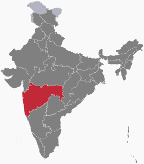
Maharashtra is a state considered to be part of western, central, southern and south-central India. It is the second-most populous state and third-largest state by area in India. Spread over 307,713 km2 (118,809 sq mi), it is bordered by the Arabian Sea to the west, the Indian states of Karnataka and Goa to the south, Telangana and Chhattisgarh to the east, Gujarat and Dadra and Nagar Haveli to the north west, and Madhya Pradesh to the north. It is also the world's second-most populous subnational entity. It was formed by merging the western and south-western parts of the Bombay State, Berar and Vidarbha, and the north-western parts of the Hyderabad State and splitting Saurashtra by the States Reorganisation Act. It has over 112 million inhabitants and its capital, Mumbai, has a population around 18 million making it the most populous urban area in India. Nagpur hosts the winter session of the state legislature. Pune is known as 'Oxford of the East' due to the presence of several well-known educational institutions.

Demographics

As of 2001 India census, [1] Ambivali Tarf Tungaratan had a population of 6796. Males constitute 55% of the population and females 45%. Ambivali Tarf Tungaratan has an average literacy rate of 73%, higher than the national average of 59.5%; with 59% of the males and 41% of females literate. 15% of the population is under 6 years of age.

Related Research Articles

Raisen Town in Madhya Pradesh, India

Raisen is a town and a municipality in Raisen district in the Indian state of Madhya Pradesh. It is the administrative headquarters of Raisen District. Raisen takes its name from the massive fort at the top of a hill. The town is located at the foot. The name is probably a corruption of Rajavasini or Rajasayan—the royal residence. The famous places to visit in Raisen district are raisen fort, dargah, and sanchi stupa.

Armapur Estate city in Uttar Pradesh, India

Armapur Estate is a census town in Kanpur Nagar District in the state of Uttar Pradesh, India.

Athipattu Suburb in Tiruvallur, Tamil Nadu, India

Athipattu is a census town in Chennai in Thiruvallur district in the state of Tamil Nadu, India. The neighbourhood is served by Athipattu railway station of the Chennai Suburban Railway network. it is a suburb in northern part of Chennai.

Barela city in Madhya Pradesh, India

Barela is a town and nagar panchayat in Jabalpur district in the state of Madhya Pradesh, India. Its other name is Dharmnagri.

Birwadi city in Maharashtra, India

Birwadi is a census town in Raigad district in the state of Maharashtra, India.

Desur town panchayat in Tamil Nadu, India

Desur is a Town panchayat in Tiruvanamalai district in the Indian state of Tamil Nadu.

Jabalpur Cantonment city in Madhya Pradesh, India

Jabalpur Cantonment is a cantonment town in Jabalpur District in the Indian state of Madhya Pradesh.

Naravarikuppam city in Tamil Nadu, India

Naravarikuppam is a town in Thiruvallur district in the Indian state of Tamil Nadu.also called redhills

Neiyyur city in Tamil Nadu, India

Neyyoor is a panchayat town in Kanniyakumari district in the Indian state of Tamil Nadu.

Neuton Chikhli Kalan city in Madhya Pradesh, India

Neuton Chikhli Kalan is a town and a nagar panchayat in Chhindwara district in the Indian state of Madhya Pradesh.

Peerkankaranai neighbourhood in Chennai, Tamil Nadu, India

Peerkankaranai is a town in Southern part of the metropolitan city of Chennai in the Indian state of Tamil Nadu.

Sonatikiri Census town in West Bengal, India

Sonatikiri is a census town under Gaighata of Bangaon subdivision in North 24 Parganas district in the Indian state of West Bengal. Gaighata police station serves it.

Thevaram Town Panchayat in Tamil Nadu, India

Thevaram is a Town Panchayat in Theni district in the Indian state of Tamil Nadu. Thevaram is located in Tamil Nadu near on border of Kerala at the Eastern side foot-hill of Western Ghats. The State Highway SH-100 passes through this town.

Vengathur is a census town in Thiruvallur district in the Indian state of Tamil Nadu.

Venkatapur, Bhatkal, Karnataka town in Karnataka, India

Venkatapur is a census town in Bhatkal Taluk in Uttara Kannada district of Karnataka.

Pipariya, Jabalpur city in Madhya Pradesh, India

Pipariya is a census town in Jabalpur district in the Indian state of Madhya Pradesh.

Gangapur, Varanasi city in Uttar Pradesh, India

Gangapur is a town and a nagar panchayat in Varanasi district in the state of Uttar Pradesh, India.

Fatehabad, Haryana Town in Haryana, India

Fatehabad is a town and a municipal committee in Fatehabad district in the state of Haryana, India.

Pimpalgaon Tarf Khed village in Maharashtra, India

Pimpalgaon Tarf Khed is a panchayat village in the state of Maharashtra, India, on the left (east) bank of the Bhima River. Administratively, Pimpalgaon Tarf Khed is under Khed Taluka of Pune District in Maharashtra. The village of Pimpalgaon Tarf Khed is 11 km east of the town of Chakan, and 23 km by road south of the town of Rajgurunagar (Khed).

Ambivali Tarf Bahare village in Maharashtra, India

Ambivali Tarf Bahare is a village in the Palghar district of Maharashtra, India. It is located in the Dahanu taluka.

References

  1. "Census of India 2001: Data from the 2001 Census, including cities, villages and towns (Provisional)". Census Commission of India. Archived from the original on 2004-06-16. Retrieved 2008-11-01.