The Cuanza Norte Province is a province of Angola. N'dalatando is the capital and the province has an area of 24,110 km² and a population of approximately 428,000. According to 1988 US government statistics, the province has a population of 365,100, with just 18,000 living in urban areas. Manuel Pedro Pacavira was born here and is a former provincial governor. The 1,400 meter long Capanda Dam is located in this province. Cuanza Norte lies on the northern bank of the Cuanza River. It had been a territory of Ngola Kingdom. In 1914, Norton de Matos created District of Cuanza which was divided into Cuanza Norte and Cuanza Sul Provinces in 1917.

Luanda is a province of Angola.
Fernando "Cobo" Pereira is a major in the military of São Tomé and Príncipe.

The Battle of Cuito Cuanavale was fought intermittently between August 14, 1987 and March 23, 1988, south and east of the town of Cuito Cuanavale, Angola, by the People's Armed Forces for the Liberation of Angola (FAPLA), Cuba, South Africa, and insurgents of the National Union for the Total Independence of Angola (UNITA) during the Angolan Civil War and South African Border War. The battle was the largest engagement of the Angolan conflict and the biggest conventional battle on the African continent since World War II. UNITA and its South African allies defeated a major FAPLA offensive towards Mavinga, preserving the former's control of southern Angola. They proceeded to launch a bloody but inconclusive counteroffensive on FAPLA defensive positions around the Tumpo River east of Cuito Cuanavale.
Operation Packer was a military operation by the South African Defence Force (SADF) during the South African Border War and Angolan Civil War from March to April 1988. This operation forms part of what became known as the Battle of Cuito Cuanavale. Operation Packer was a continuation of Operation Hooper, using fresh troops and equipment. The Cubans' objective was still to secure the town of Cuito Cuanavale to the west of the river from capture. The SADF objective was once again to eliminate the remaining Angolan forces on the east side of the river, so as to ensure that the Angolans were no longer a threat to UNITA in the south-east. Although at the conclusion some Angolan units remained in positions east of the river, the Angolan advance against UNITA was permanently halted, and UNITA lived to fight on. The SADF never attempted to cross the river or to capture the town. Both sides again claimed victory.

The giant sable antelope, (Hippotragus niger variani), also known in Portuguese as the palanca-negra-gigante, is a large, rare subspecies of sable antelope native and endemic to the region between the Cuango and Luando Rivers in Angola.
Cuito Cuanavale is a town and municipality in Cuando Cubango (Kuando-Kubango) province in Angola. The names Kuito Kuanavale or Kwito Kwanavale are sometimes used, although this is a mutation of the original Portuguese name.

La Yesa is a small town and municipality in the comarca of Los Serranos in the Valencian Community, Spain. The name in Valencian is La Iessa, but the local language is Spanish, not Valencian.

Manhiça District is a district of Maputo Province in southern Mozambique. The principal town is Manhiça. The district is located in the north of the province, and borders with Magude District in the north, Bilene Macia District of Gaza Province in the northeast, Marracuene District and the city of Maputo in the south, and with Moamba District in the west. In the east, the district is limited by the Indian Ocean. The area of the district is 2,373 square kilometres (916 sq mi). It has a population of 159,812 as of 2007.

Tarrafal is a city in the northern part of the island of Santiago, Cape Verde. In 2010 its population was 6,656. It is a fishing port situated on the northwestern coast. It constitutes the seat of the Tarrafal Municipality.
Latindex is a bibliographical information system available for free consultation. Established as a network in 1997, the project is based on the cooperation of 17 national resource centers that operate in a coordinated scheme for the gathering and dissemination of relevant information and data on the Iberoamerican journals.
Abbé René de Naurois was a French Catholic priest, chaplain, and ornithologist.
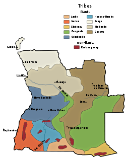
Ganguela or Nganguela is the name of a small ethnic group living in Angola, but since colonial times the term has been applied to a number of peoples East of the Bié Plateau. In addition to the Nganguela proper, this ethnographic category includes the Lwena (Luena), the Luvale, the Mbunda, the Lwimbi, the Camachi and others.
Xindonga is an ethnological term created as a common label for four small ethnic groups existing in the extreme Southeast of Angola: the Cusso (Mbukushu), the Dilico, the Sambio and the Maxico. These peoples live in that region, which today is the Cuando Cubango Province, together with other small groups, belonging to the Ovambo, Ganguela and San. The "Xindonga" peoples are living on petty subsistence agriculture, keeping small animals, and the occasional hunting and/or fishing.
The following is a complete list of rulers of the Mbunda Kingdom, established in the southeast of present-day Angola, covering Moxico and Cuando Cubango Provinces.

Johannes Gossweiler aka John Gossweiler or João Gossweiler, was state botanist to the Government of Angola from 1899 until his death. He made important collections in every district of Angola and created the first phytogeographic map of that country. His collections of African plant specimens were sent regularly to Lisbon, the British Museum, the Royal Botanic Gardens, Kew, and the University of Coimbra. Duplicates were also kept at the Herbarium of the Instituto de Investigação Agronómica in Angola. Today, many herbaria contain specimens he collected.

The Arquivo Histórico Ultramarino of Portugal preserves archives related to the Portuguese Empire. It is located in the Palácio da Ega on Calçada da Boa-Hora in the city of Lisbon, near the Rua da Junqueira in the parish of Alcântara. The Instituto de Investigação Científica Tropical of the governmental Ministry of Science, Technology and Higher Education administers the archives. Prior to 1973, the Overseas Ministry oversaw it.
José da Silva Maldonado d'Eça was a Portuguese colonial administrator. He was governor of the colony of Cape Verde from 19 June 1795 until his death on 10 September 1795. He succeeded Francisco José Teixeira Carneiro and was succeeded by Marcelino António Bastos. During his time as governor, the first cotton fields were planted in the Cape Verde Islands.