
The Alps are the highest and most extensive mountain range that is entirely in Europe, stretching approximately 1,200 km (750 mi) across seven Alpine countries : France, Switzerland, Italy, Liechtenstein, Austria, Germany, and Slovenia.
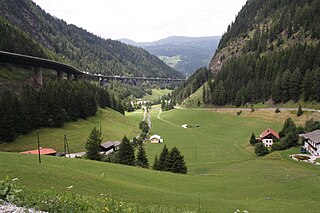
The Brenner Pass is a mountain pass through the Alps which forms the border between Italy and Austria. It is one of the principal passes of the Eastern Alpine range and has the lowest altitude among Alpine passes of the area.

Salzburg is a province (Land) of Austria. It is officially named Land Salzburg to distinguish it from its eponymous capital — the city of Salzburg. For centuries, it was an independent Prince-Bishopric of the Holy Roman Empire.

Lower Austria is one of the nine states of Austria, located in the northeastern corner of the country. Since 1986, the capital of Lower Austria has been Sankt Pölten, replacing Vienna which became a separate state in 1921. With a land area of 19,186 km2 (7,408 sq mi) and a population of 1.685 million people, Lower Austria is the second-most populous state in Austria. Other large cities are Amstetten, Klosterneuburg, Krems an der Donau, Stockerau and Wiener Neustadt.

Vorarlberg is the westernmost state of Austria. It has the second-smallest geographical area after Vienna and, although it also has the second-smallest population, it is the state with the second-highest population density. It borders three countries: Germany, Switzerland, and Liechtenstein. The only Austrian state that shares a border with Vorarlberg is Tyrol, to the east.
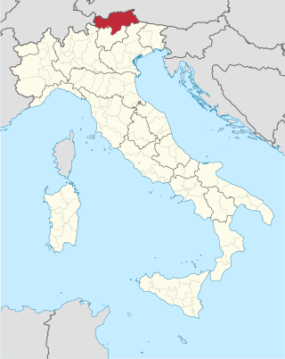
South Tyrol, officially the Autonomous Province of Bolzano, is an autonomous province in Northern Italy, one of the two that make up the autonomous region of Trentino-Alto Adige/Südtirol. The province is the northernmost of Italy, the second largest, with an area of 7,400 square kilometres (2,857 sq mi) and has a total population of about 534,000 inhabitants as of 2021. Its capital and largest city is Bolzano.

Leontopodium nivale, commonly called edelweiss, is a mountain flower belonging to the daisy or sunflower family Asteraceae. The plant prefers rocky limestone places at about 1,800–3,000 metres (5,900–9,800 ft) altitude. It is non-toxic and has been used in traditional medicine as a remedy against abdominal and respiratory diseases. Its leaves and flowers are covered with dense hairs, which appear to protect the plant from cold, aridity, and ultraviolet radiation. It is a scarce, short-lived flower found in remote mountain areas and has been used as a symbol for alpinism, for rugged beauty and purity associated with the Alps and Carpathians. It is a national symbol, especially of Romania, Austria, Slovenia, Switzerland, and Italy. According to folk tradition, giving this flower to a loved one is a promise of dedication.

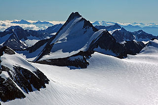
The Grossglockner, or just Glockner, is, at 3,798 metres above the Adriatic (12,461 ft), the highest mountain in Austria and the highest mountain in the Alps east of the Brenner Pass. It is part of the larger Glockner Group of the Hohe Tauern range, situated along the main ridge of the Central Eastern Alps and the Alpine divide. The Pasterze, Austria's most extended glacier, lies on the Grossglockner's eastern slope.
The Ötztal Alps are a mountain range in the Central Eastern Alps, in the State of Tyrol in western Austria and the Province of South Tyrol in northern Italy.

The Pannonian Basin, or Carpathian Basin, is a large basin situated in south-east Central Europe. The geomorphological term Pannonian Plain is more widely used for roughly the same region though with a somewhat different sense, with only the lowlands, the plain that remained when the Pliocene Epoch Pannonian Sea dried out.
German Division Nr. 188 was raised in late 1939. It consisted of the 136th, 138th and 139th Mountain Replacement Regiments and the 112th Artillery Replacement Regiment, plus supporting units. It began the war on border guard duty in the mountainous region between Austria and Yugoslavia with the primary mission of training reservists and replacements for the regular mountain divisions. In the spring of 1941 it joined the invasion of Yugoslavia, with the three mountain regiments given responsibility of seizing control of Carniola and Carinthia on the Yugoslav side of the border, which they carried out quickly and effectively against little to no resistance.
The Jagdkommando is the Austrian Armed Forces' special forces unit. The unit is based at Wiener Neustadt.

Gebirgsjäger are the light infantry part of the alpine or mountain troops (Gebirgstruppe) of Germany, Austria and Switzerland. The word Jäger is a characteristic term used for light infantry in German speaking countries.

Eastern Alps is the name given to the eastern half of the Alps, usually defined as the area east of a line from Lake Constance and the Alpine Rhine valley up to the Splügen Pass at the Alpine divide and down the Liro River to Lake Como in the south. The peaks and mountain passes are lower than the Western Alps, while the range itself is broader and less arched.

Schladming is a small former mining town in the northwest of the Austrian state of Styria that is now a popular tourist destination. It has become a large winter-sports resort and has held various skiing competitions, including most notably the FIS Alpine World Ski Championships 1982 and the FIS Alpine World Ski Championships 2013. The shopping area has many cafes and restaurants, and a variety of shops that cater to tourists.

The Austrian Academy of Sciences is a legal entity under the special protection of the Republic of Austria. According to the statutes of the Academy its mission is to promote the sciences and humanities in every respect and in every field, particularly in fundamental research.

The Lavanttal Alps are part of the Central Eastern Alps in Austria and Slovenia, between the river Mur in the north and the Drava in the south.

