Amory Lock

Last updated
Amory Lock
USACE Amory Lock.jpg
Amory Lock and Dam
Waterway Tennessee–Tombigbee Waterway
CountryUnited States
State Mississippi
County Monroe County
Maintained by United States Army Corps of Engineers
OperationHydraulic
First built1984
Length600 ft (180 m)
Width110 ft (34 m)
Fall30 ft (9.1 m)
Coordinates 34°00′40″N88°29′21″W / 34.01111°N 88.48917°W / 34.01111; -88.48917 (Amory Lock and Dam)
Amory Lock Amory Lock 20050910.JPG
Amory Lock

The Amory Lock (formerly named Lock A) is a lock and dam on the Tennessee-Tombigbee Waterway.

Contents

Location

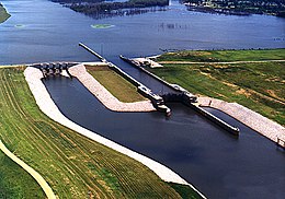
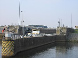
The Amory Lock is located in the city of Amory, Mississippi, and the waterway forms the west and north boundary of the city. Mississippi Highway 6 crosses the waterway at an overpass south of the Amory Lock.

Amory, Mississippi City in Mississippi, United States

Amory is a city in Monroe County, Mississippi, United States. The population was 7,316 as of the 2010 census.

The Amory Lock is located at mile 371.1 on the waterway, representing the navigational distance from the southern end of the waterway at the Cochrane–Africatown USA Bridge on U.S. Route 90 in Mobile, Alabama. [1]

Cochrane–Africatown USA Bridge bridge in United States of America

The Cochrane–Africatown USA Bridge is a cable-stayed bridge carrying US 90/US 98 Truck across the Mobile River from the mainland to Blakeley Island in Mobile, Alabama.

U.S. Route 90 United States historic place

U.S. Route 90 or U.S. Highway 90 is an east–west major United States highway in the Southern United States. Despite the "0" in its route number, US 90 never was a full coast-to-coast route; it has always ended at Van Horn, Texas with the exception of a short-lived northward extension to US 62/US 180 near Pine Springs, Texas which lasted less than a year, and the signs on that segment were changed to Texas State Highway 54, traveling from Interstate 10 (I-10) at exit 140A and heading to its northern terminus at US 62/US 180.

Mobile, Alabama City in Alabama, United States

Mobile is the county seat of Mobile County, Alabama, United States. The population within the city limits was 195,111 as of the 2010 United States Census, making it the third most populous city in Alabama, the most populous in Mobile County, and the largest municipality on the Gulf Coast between New Orleans, Louisiana, and St. Petersburg, Florida.

Specifications

The Amory Lock was constructed at a cost of $23.3 million, and it created a 914 acres (370 ha) lake north of the lock and dam. [2]

All locks on the waterway use marine radio channel 16 for standby; the Amory Lock's unique marine radio channel is 14. [1]

Schedule

All locks of the Tennessee-Tombigbee Waterway operate 24 hours a day, 7 days a week. For large vessels, lock operation is made on demand. For pleasure boats using the Amory Lock, the lock operates in the morning at 5, 7, 9, and 11 A.M., and in the afternoon at 1, 3, 5, and 7 P.M. [1]

Priority of usage

Certain vessels are given priority over others wishing to use the Amory Lock. The priority status from greatest to least is: U.S. military craft, commercial passenger craft, commercial tows, commercial fisherman, pleasure boats. [1]

Related Research Articles

Saint Lawrence Seaway Locks & canals in the USA and Canada

The Saint Lawrence Seaway is a system of locks, canals, and channels in Canada and the United States that permits oceangoing vessels to travel from the Atlantic Ocean to the Great Lakes of North America, as far inland as Duluth, Minnesota at the western end of Lake Superior. The seaway is named for the Saint Lawrence River, which flows from Lake Ontario to the Atlantic Ocean. Legally, the seaway extends from Montreal, Quebec, to Lake Erie and includes the Welland Canal.

Tishomingo County, Mississippi County in the United States

Tishomingo County is a county located in the northeast corner of the U.S. state of Mississippi. As of the 2010 census, the population was 19,593. Its county seat is Iuka.

Tennessee River river in the United States, its largest city is Knoxville, TN

The Tennessee River is the largest tributary of the Ohio River. It is approximately 652 miles (1,049 km) long and is located in the southeastern United States in the Tennessee Valley. The river was once popularly known as the Cherokee River, among other names, as many of the Cherokee had their territory along its banks, especially in eastern Tennessee and northern Alabama. Its current name is derived from the Cherokee village Tanasi.

Tombigbee River river in the United States of America

The Tombigbee River is a tributary of the Mobile River, approximately 200 mi (325 km) long, in the U.S. states of Mississippi and Alabama. Together with the Alabama, it merges to form the short Mobile River before the latter empties into Mobile Bay on the Gulf of Mexico. The Tombigbee watershed encompasses much of the rural coastal plain of western Alabama and northeastern Mississippi, flowing generally southward. The river provides one of the principal routes of commercial navigation in the southern United States, as it is navigable along much of its length through locks and connected in its upper reaches to the Tennessee River via the Tennessee-Tombigbee Waterway.

Fox–Wisconsin Waterway

The Fox–Wisconsin Waterway is a waterway formed by the Fox and Wisconsin Rivers. First used by European settlers in 1673 during the expedition of Marquette & Joliet, it was one of the principal routes used by travelers between the Great Lakes and the Mississippi River until the completion of the Illinois and Michigan Canal in 1848 and the arrival of railroads. The western terminus of the Fox–Wisconsin Waterway was at the Mississippi at Prairie du Chien, Wisconsin. It continued up the Wisconsin River about 116 miles (187 km) until reaching Portage, Wisconsin. There travelers would portage to the Upper Fox River, or eventually, use the Portage Canal. It continued about 160 miles (257 km) down the Fox River, following it through Lake Winnebago and continuing on the Lower Fox over 170 feet of falls to the eastern terminus of Green Bay.

Tennessee–Tombigbee Waterway canal in the United States of America

The Tennessee–Tombigbee Waterway is a 234-mile (377 km) man-made waterway that extends from the Tennessee River to the junction of the Black Warrior-Tombigbee River system near Demopolis, Alabama, United States. The Tennessee–Tombigbee Waterway links commercial navigation from the nation's midsection to the Gulf of Mexico. The major features of the waterway are ten locks and dams, a 175-foot-deep (53 m) cut between the Tombigbee River watershed and the Tennessee River watershed, and 234 miles (377 km) of navigation channels. The ten locks are 9 by 110 by 600 feet, the same dimension as the locks on the Mississippi above Lock and Dam 26 at Alton, Illinois. Under construction for twelve years by the U.S. Army Corps of Engineers, the Tennessee–Tombigbee Waterway was completed in December 1984 at a total cost of nearly $2 billion.

John C. Stennis Lock and Dam

The John C. Stennis Lock and Dam, formerly named Columbus Lock and Dam, is one of four lock and dam structures on the Tennessee-Tombigbee Waterway that generally lie along the original course of the Tombigbee River. It is located near Columbus, Mississippi, and impounds Columbus Lake. It is named for longtime U.S. Senator from Mississippi, John C. Stennis.

Aberdeen Lock and Dam dam in Aberdeen, Mississippi

The Aberdeen Lock and Dam is one of four lock and dam structures on the Tennessee-Tombigbee Waterway that generally lie along the original course of the Tombigbee River. It is located east of Aberdeen in Monroe County, Mississippi and impounds Aberdeen Lake.

Tom Bevill Lock and Dam dam in Pickens County, Alabama, United States of America

The Tom Bevill Lock and Dam, formerly named Aliceville Lock and Dam, is one of four lock and dam structures on the Tennessee-Tombigbee Waterway that generally lie along the original course of the Tombigbee River. It is located near Aliceville, Alabama and impounds Aliceville Lake. It is named for Tom Bevill, a proponent of the Tenn-Tom.

Fulton Lock

The Fulton Lock is a lock and dam on the Tennessee-Tombigbee Waterway.

Jamie Whitten Lock and Dam dam in Tishomingo County, Mississippi, United States of America

The Jamie Whitten Lock and Dam is part of the Tennessee-Tombigbee Waterway. It is located in south Tishomingo County, Mississippi, United States, close to the Prentiss County line.

Industrial Canal canal in Louisiana, United States of America

The Industrial Canal is a 5.5 mile (9 km) waterway in New Orleans, Louisiana, United States. The waterway's proper name, as used by the U.S. Army Corps of Engineers and on NOAA nautical charts, is Inner Harbor Navigation Canal (IHNC). The more common "Industrial Canal" name is used locally, both by commercial mariners and by landside residents.

Inland waterways of the United States

The inland waterways of the United States include more than 25,000 mi (40,000 km) of navigable waters. Much of the commercially important waterways of the United States consist of the Mississippi River System—the Mississippi River and connecting waterways.

Pickwick Landing Dam dam in Pickwick Dam, Hardin County, Tennessee, United States

Pickwick Landing Dam is a hydroelectric dam on the Tennessee River in Hardin County, in the U.S. state of Tennessee. The dam is one of nine dams on the river owned and operated by the Tennessee Valley Authority, which built the dam in the 1930s as part of a New Deal-era initiative to create a continuous navigation channel between the river's mouth and Knoxville, and bring economic development to the area. The dam impounds the 43,100-acre (17,400 ha) Pickwick Lake and its tailwaters are part of Kentucky Lake.

Kentucky Dam dam in Livingston County and Marshall County, Kentucky, United States

Kentucky Dam is a hydroelectric dam on the Tennessee River on the county line between Livingston and Marshall counties in the U.S. state of Kentucky. The dam is the lowermost of nine dams on the river owned and operated by the Tennessee Valley Authority, which built the dam in the late 1930s and early 1940s to improve navigation on the lower part of the river and reduce flooding on the lower Ohio and Mississippi rivers. It was a major project initiated during the New Deal of President Franklin D. Roosevelt's administration, to invest in infrastructure to benefit the country. The dam impounds the Kentucky Lake of 160,000 acres (65,000 ha), which is the largest of TVA's reservoirs and the largest artificial lake by area in the Eastern United States. It was listed on the National Register of Historic Places in 2017.

McClellan–Kerr Arkansas River Navigation System Part of the inland waterway system originating at the Tulsa Port of Catoosa and running southeast through Oklahoma and Arkansas to the Mississippi River

The McClellan–Kerr Arkansas River Navigation System (MKARNS) is part of the inland waterway system originating at the Tulsa Port of Catoosa and running southeast through Oklahoma and Arkansas to the Mississippi River. The system was named for two Senators: Robert S. Kerr (D-OK) and John L. McClellan (D-AR), who pushed authorizing legislation through Congress. The system officially opened June 5, 1971. President Richard M. Nixon attended the opening ceremony. It is operated by the Corps of Engineers.

Lock and Dam No. 3 dam in Red Wing, Goodhue County, Minnesota / Diamond Bluff, Pierce County, Wisconsin, United States.

Lock and Dam No. 3 is a lock and dam located near Red Wing, Minnesota on the Upper Mississippi River around river mile 796.9. It was constructed and placed in operation July 1938. The site underwent major rehabilitation from 1988 through 1991. The dam is 365 feet (111.3 m) long with 4 roller gates. More than 2,000 feet (609.6 m) of earth embankment with a series of upstream spot dikes completes the structure to create Pool 3. The lock chamber is 110 feet (33.5 m) wide by 600 feet (182.9 m) long. The lock and dam is owned and operated by the St. Paul District of the United States Army Corps of Engineers-Mississippi Valley Division.

Chain of Rocks Lock dam in Madison / Granite City, Illinois, USA

Chain of Rocks Lock and Dam, also known as Locks No. 27, is a lock situated at the southern end of Chouteau Island near St. Louis, Missouri on the Upper Mississippi River. Its associated dam is just downstream of the Chain of Rocks Bridge, and the lock is located over 3 miles (4.8 km) southeast on the Chain of Rocks canal. The canal and locks allow river traffic to bypass a portion of the river that is unnavigable in low water due to an anticlinal exposure of bedrock in the river—a "chain of rocks".

The Black Rock Lock located in Buffalo, New York is 650 feet (200 m) in length and 70 feet (21 m) wide. There is only one chamber and the total weight of the gate is 480 tons. The lock has been a part of Black Rock since the state of New York built the Erie Canal in 1833.

References

  1. 1 2 3 4 "Tennessee-Tombigbee Waterway". U.S. Army Corps of Engineers. Retrieved May 21, 2017.
  2. "Tennessee-Tombigbee Locks". Tennessee-Tombigbee Waterway. Archived from the original on August 17, 2011. Retrieved May 21, 2017.